The Climate Resilience team of the European Space Agency (ESA)’s Global Development Assistance (GDA) programme has collaborated with the World Bank on their ‘Next Generation MRV for Land Use Emissions Reduction Programs’ project to complete a proof-of-concept prototype of a new Measurement, Reporting and Verification (MRV) product. A tool that can monitor greenhouse gas (GHG) emissions from land use change. The development and deployment of a next-generation digital monitoring system, known as MRV2.0, could impact nature-based mitigation activities by enabling the measurement, reporting, and verification of forests’ CO2 emission reductions and enhanced removals with unprecedented efficiency and accuracy.
The collaboration between ESA’s GDA Climate Resilience Consortium and the World Bank supported the efforts of the Forest Carbon Partnership Facility (FCPF). This global partnership includes governments, businesses, civil society, and indigenous peoples’ organisations, all dedicated to reducing emissions caused by deforestation and forest degradation, through sustainable management and enhancement of forests and forest carbon stocks. These efforts are part of the activities known as Reducing Emissions from Deforestation and Forest Degradation (REDD+) under the United Nations Convention on Climate Change (UNFCCC).
The FCPF has granted funding to Mozambique to support the establishment of a REDD+ framework and associated REDD+ activities. One of the programmes the FCPF funded is the Zambezia Integrated Landscape Management Program (ZILMP) which is trying to assess and monitor forest resources and targeted conservation and restoration efforts.
To monitor forest resources in remote areas, the ZILMP requires transparent, reliable and consistent information on above-ground biomass (AGB) to take stock of the national forest resources and closely and accurately monitor changes, both gains and losses. As these efforts are tied to funding, the monitoring processes must be accurate, rapid and cost-effective.
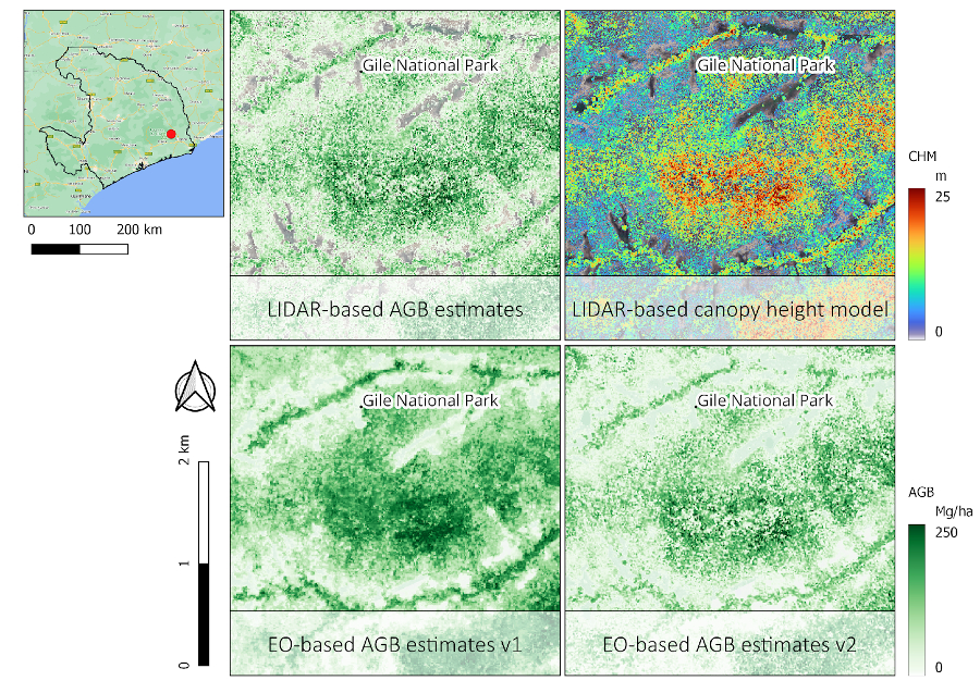
Recognising the need for a streamlined approach, the World Bank collaborated with the Consortium to leverage Earth Observation (EO) information products to enhance the estimation of AGB and support model-based change assessments.
The MRV2.0 product includes satellite data to help measure above-ground biomass (AGB), which is a crucial component of MRV processes. The MRV2.0 system is a significant improvement to its predecessor. It is based on precise ground-truthing using drone Light Detection and Ranging (LIDAR), a remote sensing technology that uses laser light to measure distances and create high-resolution three-dimensional representations of objects and landscapes. This allows carbon stocks to be estimated across large areas. This is a novel approach, as few MRV processes use satellite data to estimate carbon stock dynamics today. The improved accuracy of the MRV2.0 will make it easier for countries to carry out their GHG National Inventory Reports.
Advancements and Future Prospects
The demonstration project was well-received due to its notable precision and accuracy, attracting positive feedback from the World Bank and other stakeholders. These points were thoroughly examined during a three-day project review meeting with the World Bank and ESA’s GDA Climate Resilience consortium, where the focus was on integrating remote-sensing-based digital MRV systems. It was determined that official adoption of these systems would require not only proof of accuracy and comprehensive documentation, but also formal registration with recognised certification bodies. The formal registration and certification of this methodology is vital for its recognition and consideration for REDD+ activities. Certification bodies like VCS, CCBS, Gold Standard, and ACR play a crucial role in maintaining the integrity of REDD+ projects. Verified Carbon Standard (VCS), administered by Verra, in particular, has been mentioned as one of the most widely used certification standards for REDD+ projects. It provides rigorous requirements for the quantification, monitoring, and verification of GHG reductions and removals. The certification process typically involves several key steps:
- Submission of Methodologies: Project developers submit their methodologies for measuring and monitoring deforestation, forest degradation, and carbon stock changes to relevant certification bodies. These methodologies must be detailed, scientifically sound, and conform to international standards.
- Validation and Verification: Independent third-party auditors review and assess the methodologies to ensure they meet the required standards. Validation ensures the methodology is appropriate and credible, while verification involves checking the actual data collected against the approved methodology.
- Registration: Once validated and verified, the methodologies and data are formally registered with a certification body. This step confirms that the data sources and methods are recognized and approved for use in REDD+ projects.
- Monitoring and Reporting: Continuous monitoring is conducted according to the certified methodologies, and regular reports are submitted to the certification bodies. These reports document the project’s performance in reducing emissions or increasing carbon sequestration.
- Re-verification: Periodic re-verification by third-party auditors ensures ongoing compliance with the certification standards and the accuracy of the reported data.
Following a successful certification, the registered methodology will be internationally recognized as a valid and tested data collection and AGB estimation process. It must be said, however, that the process is lengthy and best implemented in collaboration with experts that have previously gone through this process.
In any case, the initial step toward a functional solution has been achieved by demonstrating the effectiveness of the technical solution, especially when calibrated with accurate and reliable ground truth data. Moving forward, the process will involve detailed documentation, methodological reviews, and the necessary registration to certify and officially recognise this approach.
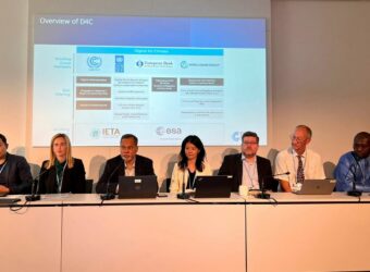
This work was also recently presented to the Digital 4 Climate working group to discuss opportunities for follow up activities and scale up. Digital For Climate (D4C) is a collaboration between the European Bank for Reconstruction and Development (EBRD), United Nations Development Program (UNDP), United Nations Framework Convention on Climate Change (UNFCCC), ESA, International Emissions Trading Association (IETA) and the World Bank Group that aims to coordinate respective workflows and create a modular and interoperable end-to-end digital ecosystem for the carbon market. In the context of those discussions, the different members of the group are currently discussing a coordinated approach regarding the next steps that could be implemented.
These enhancements in MRV systems are poised to improve the reporting capabilities of client countries. By facilitating more precise and timely data collection coupled with greater transparency, these countries can more efficiently report emissions reductions from land-use projects and access climate finance more promptly. These advancements will ultimately help expedite payments to local communities and improve the distribution of climate funds, promoting sustainable land-use practices.
Learn more about how ESA’s earth observation data has been used for Land & Forestry projects here.
Key Takeaways
- The World Bank and the European Space Agency’s Global Development Assistance Climate Resilience Consortium have developed a prototype product that estimates forest biomass to calculate and monitor greenhouse gas emissions.
- The Measurement, Reporting and Verification process integrates satellite-based methods that ensure higher-confidence emissions estimates.
- The updated system uses precise ground-truthing, allowing for estimating carbon stocks across large areas.
- Satellite-based methods enable client countries to report to land-use climate funds more promptly and ultimately enable local communities to receive payments quicker.
ESA’s GDA Programme is a global partnership implemented with key International Financial Institutions (IFIs) – World Bank and Asian Development Bank – to mainstream the use of Earth Observation (EO) into development operations. For more information, please visit our website: https://gda.esa.int









![[VIDEO] Earth Observation for Climate Resilient Flood Management in South Sudan](https://gda.esa.int/wp-content/uploads/2023/11/Earth-Observation-for-Climate-Resilient-Flood-Management-2-340x250.jpg)
