In 2022, Belize’s exports of banana, citrus, and sugarcane collectively contributed 4.6% of the nation’s Gross Domestic Product (GDP). Sugarcane production is concentrated in the Orange Walk district in the north, targeting markets in the US and UK, while banana and citrus produce thrive in the southern regions of Cayo, Stann Creek, and Toledo. However, this agricultural prosperity is increasingly imperilled by climate change, which threatens the foundation of Belize’s agrarian economy.
Recent years have seen climate change wreak havoc on Belize’s fields, with drought-induced crop failures and shortened growing seasons hitting the vital sugarcane industry hard. In response, the Government of Belize launched the Climate Resilient and Sustainable Agriculture Project (CRESAP) to strengthen agricultural productivity and build resilience against climate change. A cornerstone of CRESAP is the expansion of the Belize Agriculture Information Management System (BAIMS), a critical step in leveraging data-driven solutions to tackle the sustainability challenges facing Belizean agriculture.
The European Space Agency’s (ESA) Global Development Assistance (GDA) programme supports initiatives like CRESAP by providing Earth Observation (EO) services tailored to the needs of developing nations. These projects address challenges such as risk assessment, food production monitoring, and development planning, while supporting mitigation actions in agriculture. The integration of EO data within BAIMS underscores this innovative use case.
We developed various tools to empower farmers and policymakers alike. This was done in collaboration with the World Bank and local experts within the Ministry of Agriculture, Food Security, and Enterprise (MAFSE), the Belize Social Investment Fund (BSIF), the National Meteorological Service (NMS), the Sugar Industry Research and Development Institute (SIRDI) and the Belize Agricultural Health Authority (BAHA).
Crop Type Classification

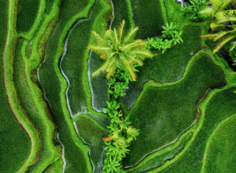
Our first innovation is a crop type classification whereby we leveraged state-of-the-art satellite imagery to pinpoint the precise locations of sugarcane, citrus, and banana in the Orange Walk, Cayo, Stann Creek, and Toledo districts. Using a combination of Sentinel-1 SAR and Sentinel-2 optical imagery, we identified the major production regions for sugarcane, citrus, and banana at 10 m resolution. To accurately identify these areas at such a high detail, we used multiannual composites (2020-2022) to better distinguish the crops’ perennial nature from other land cover and crop types. Like in the available agricultural statistics, sugarcane production was dominating the Northern regions, citrus groves were identified more centrally, and banana fields were found southernmost. Validation using an independent dataset indicated high accuracy values (F1-score are close to 1).
Deforestation
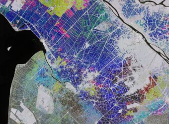
To support sustainability within CRESAP, we provided the Global Forest Watch product for integration into BAIMS. By comparing this available product to existing land cover information (e.g., ESA WorldCover) and our crop type mapping results, in-depth analyses on deforestation history could be performed. An example is shown below, where our analysis revealed a sobering truth: 70.000 ha of forest cover has been lost in the Orange Walk district since 2001, equivalent to a 20% decrease in tree cover. Up to 50% of this was converted into grasslands (as classified by ESA WorldCover 2021) – 9% can be attributed to sugarcane production. We further indicated hotspots of deforestation in the south – with the border of Cayo, centrally around the town of Indian Creek, and in the Northwest – close to the border with Mexico.

Variability in Climate
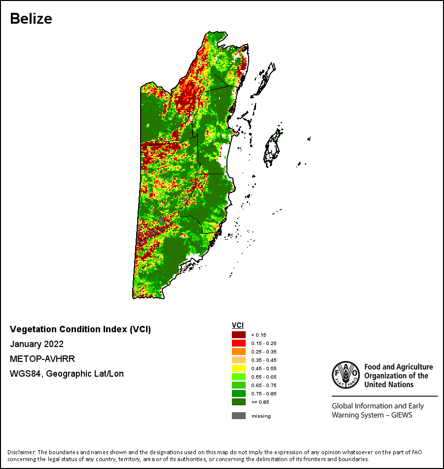
Perhaps the most pressing challenge lies in the whims of climate. Drought monitoring offers near real-time insights into meteorological anomalies that threaten Belize’s agriculture. A comparison of monthly precipitation anomalies for each district shows a stark divide between northern and southern districts (separated by the dashed line). Southern regions of Stann Creek and Toledo have experienced a healthy alteration of wetter and drier months, while the Northern districts have experienced almost exclusively drier months than usual, starting from 2015 onwards.

Geographically targeting irrigation infrastructure investments
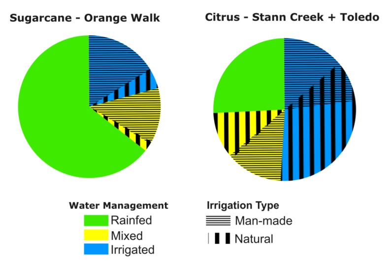
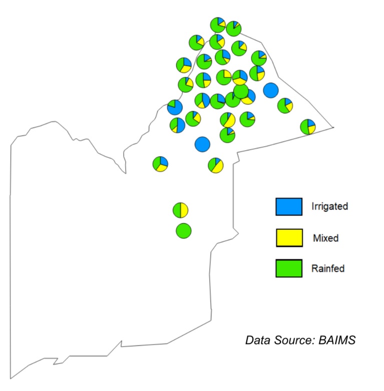
Simultaneously, there is a stark distinction in water sources between sugarcane cropping on the one hand, and citrus and banana cultivation on the other hand. Up to 64% of all sugarcane extent in Orange Walk relies solely on precipitation, while this is true for only 26% of the citrus groves in Stann Creek and Toledo. Citrus cultivation is bolstered by irrigation infrastructure – both from natural water sources (river, pond, stream) as from man-made water sources (community water system, well). Combining this information reveals a mismatch between existing irrigation infrastructure and where it was needed in the last few years.
The consequences of this mismatch are also clear when looking at the observed effects on vegetation productivity. Using the Vegetation Condition Index (VCI) from the FAO ASIS Toolbox, hotspots of low vegetation productivity were observed for 2022-2023 in the Orange Walk district – particularly at areas that overlap with grasslands (following ESA WorldCover) and sugarcane fields (following our own crop type mapping). Such dramatic effects could not be observed systematically in Stann Creek or Toledo, where drought risk is less pressing – and is better combatted through irrigation infrastructure. This signals a clear call for targeted intervention in the Orange Walk.
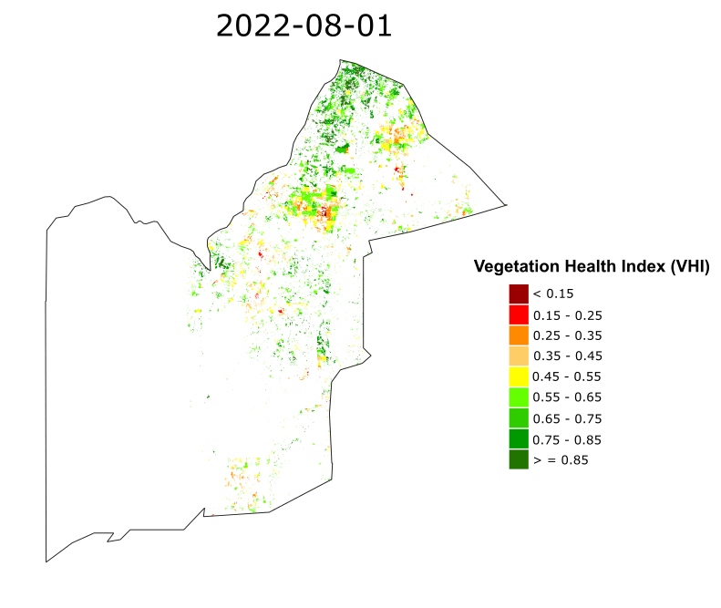
Zooming into the sugarcane growing season of 2022-2023 in the Orange Walk district, issues become even more clear. Through visualising the temporal dynamics of the Vegetation Health Index (VHI) from the FAO ASIS Toolbox for the identified sugarcane regions, important hotspots of VHI appear – highlighting a need for action. This information is particularly useful when aligned with data already existing within BAIMS, such as the share of irrigation within each village.
Uptake of EO in IFI-funded initiatives
A key objective of CRESAP is to enhance BAIMS by incorporating EO-based analytics to support data-driven agricultural decision-making. While integration has not yet been implemented, VITO’s EO layers are accessible via WMS functionalities, laying the groundwork for future adoption. The Ministry of Agriculture, Food Security, and Enterprise (MAFSE) is actively building its GIS capacity, with discussions underway to provide continued support for integrating EO data into BAIMS. National financing institutions have also shown interest in leveraging this data once available, recognising its potential to improve investment strategies and risk assessments. The successful demonstration of EO under CRESAP underscores its value in agricultural planning and IFI workstreams, positioning it as a model for broader adoption in future development initiatives.
Expanding functionalities to improve future analyses and harness data-driven solutions
An integral part of CRESAP is expanding the functionalities in the Belize Agriculture Information Management System (BAIMS), which marks a pivotal step forward in harnessing data-driven solutions to combat the challenges facing sustainability and climate resilience of Belizean agriculture.
To this end, the EO-layers prepared by VITO for this particular use case have all been made available to be plugged into BAIMS via WMS functionalities. Similarly, drought indicators from FAO’s ASIS system, already available on a 10-daily basis through WMS connection, are ready to be plugged into BAIMS.
In parallel, MAFSE is currently adding GIS capacity to their staffing structure. Integrating GIS functionalities into the BAIMS system will allow the EO-layers developed under this use case to be visualised and correlated with the other georeferenced information already available into BAIMS, as well as with ASIS indices. Such an integration will eventually improve the complexity of analyses possible within BAIMS for both policymakers and local farmers.