Understanding the current usage of satellite Earth Observation (EO) information in the activities of the International Financial Institutions (IFIs)
The European Space Agency (ESA) Global Development Assistance (GDA) programme is a global partnership with the objectives of mainstreaming the use of satellite EO into development operations.
As part of the M&E and Impact Assessment (GDA M&E) activity Caribou Space completed an Initial State of Play for ESA. This was designed to provide a summary of the “baseline” situation at the start of GDA. The report used desk research and key informant interviews to gather an understanding of the ongoing activities across eight IFIs with a “deep-dive” focus on the World Bank (WB) and Asian Development Bank (ADB), ESA’s primary collaboration partners.
We were particularly interested to hear about the current level of awareness of the potential value of EO imagery in development financing operations and the extent to which EO technologies are already being used.
EO usage in the World Bank project cycle
We found examples of both the WB and the ADB using EO throughout their programme lifecycles. That is to say, that EO is being used to design and prioritise project interventions, to support the implementation of these interventions in country and to monitor ongoing activities and track what happens at the end of the project. Representatives from the operational teams in both organisations reported that the level of awareness and acceptance of EO has been growing rapidly over the past ten years, a trend that has been attributed to three factors:
- Structural changes within the organisation that have increased the visibility of geospatial experts. This includes dedicated teams such as the WB’s Geospatial Operations Support Team (GOST) or the use of specialist consultants with geospatial knowledge on ADB projects.
- General ecosystem changes such as the large public investments (such as Europe’s Copernicus, NASA Landsat, etc) that have significantly increased access to huge volumes of data, combined with dedicated initiatives such as ESA’s EO4SD and GDA programmes.
- Environmental factors, including the Covid-19 pandemic which have led to increased remote working and remote monitoring of projects, and accelerated the need for technologies that enable this.

ESA collaborations with the WB mapped to recent project level data
We also explored whether these trends would be visible in quantitative data. Using available publicly available information on WB funded projects, we were able to scan Project Initiation Documents (PIDs) for a series of keywords to identify those that intended to use satellite EO technology and remote sensing. Using this methodology, we saw a clear increase in the share of projects with an EO-related element, coinciding with the start of ESA-funded initiatives just over a decade ago.

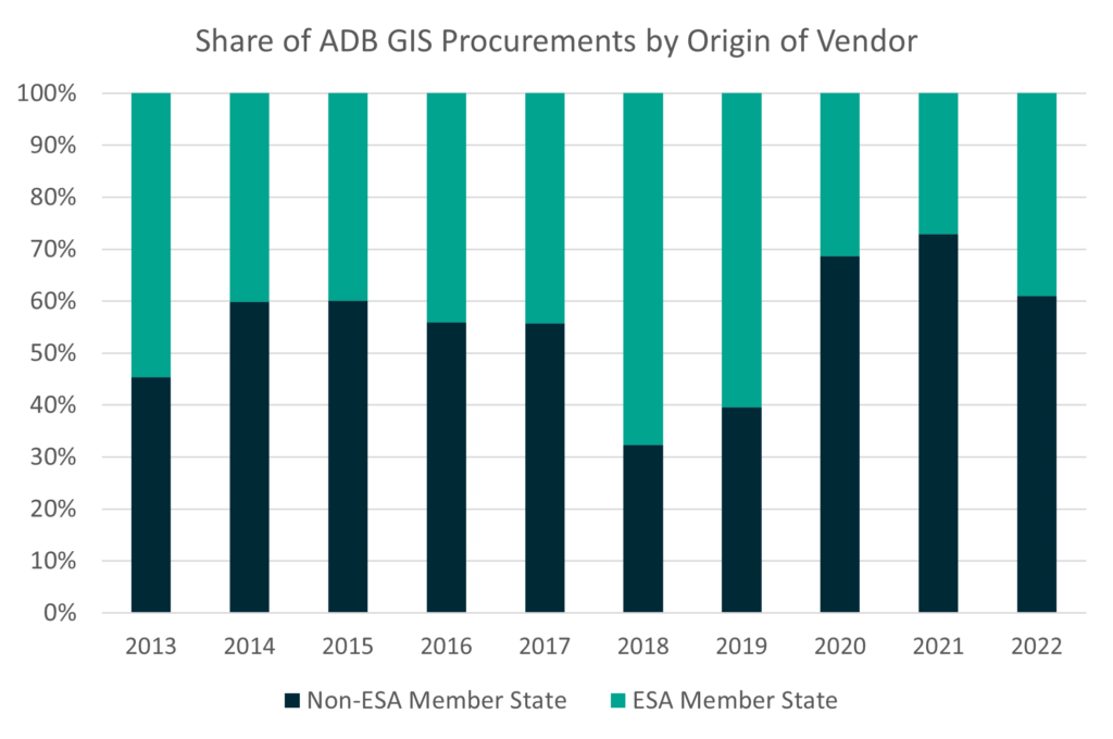
In the ADB, we accessed procurement data to analyse contracts awarded for GIS-related activities over the period of 2013-2022. This data showed that just under 50% of all procurements over this decade were awarded to firms or individuals from ESA member states.
Next steps: The Initial State of Play document has provided ESA with useful insights into current IFI operations and the operational units and project teams that are relevant for the work of GDA.
At the baseline point, we have identified 45 projects in 45 countries across the two IFIs that were already engaging with GDA AID consortia. As part of the GDA M&E activity, we will continue to track this number and – through our annual GDA reviews – will look for signs of not only increased awareness of EO within these teams, but also for examples of where EO technology is delivering clear value for these IFI teams, their Client States, and beyond.


