Forest Management
Thematic overview
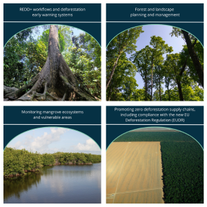
Forests are an important habitat with multiple functions and play a major role as global carbon sinks. While forests offer a potential solution to ongoing challenges in climate change mitigation, their sustainability is increasingly under threat. Pressure towards expanding agricultural land leads to illegal deforestation, habitat and biodiversity loss, and deprives forest-dependent communities of their livelihoods. Monitoring forests is crucial and Earth Observation (EO) is the only cost-effective solution, providing global, comprehensive, accurate, repeatable and timely information, and is invaluable in the planning, implementation and impact assessment of Forestry Management activities at larger scales. The GDA Forest Management activity will jointly develop new EO based Information Developments (EOIDs) to support International Financial Institutions (IFIs) and counterparts to address existing challenges. Earth Observation based Information Developments (EOIDs) under the GDA Forest activity will address several broader topics, which cover each multiple themes.1. REDD+, which will include Forest Inventories, REDD+ Workflows, Deforestation Early Warning Systems.
2. Forest and Landscape Assessment and Planning, which will include Forest Inventories, Landscape Spatial Planning and Management.
3. Mangrove and Protected Areas, which include the Monitoring Vulnerable Areas, Deforestation Early Warning Systems, and Monitoring of Mangroves.
4. Zero Deforestation (ZD), which includes Deforestation Early Warning Systems and Deforestation free supply chains, such as the new European Deforestation Regulation (EUDR).
Forest management themes
- Forest Inventories Enhance efficiency and effectiveness of forest inventories (including mangroves) using Earth Observation (EO). GDA Forest will providing general forest resource and use information (data, map products, etc.) for sustainable forest management, planning, harvesting, etc.
- Landscape Spatial Planning and Sustainable Management Use of remote sensing for landscape monitoring, land-use planning and management including the digitization of agricultural, forestry and mining map data. This could support natural capital accounting, spatial planning, and land-use modelling approaches, and forest governance, and provide measures on the performance and effectiveness of the related initiatives.
- REDD+ Workflows Use and integration of EO products into REDD+ workflows to track and verify the impacts of the forest sector and to ensure that forest and non-forest emissions are not underestimated or omitted in the forest sector layer. Those products can help to enhance overall accuracy of deforestation estimations for the elaboration of Forest Reference Emissions levels (FRL) submissions – and could contribute to the implementation of innovative digital Measurement, Reporting and Verification (MRV) systems.
- Deforestation Early-Warning Systems Support to the set-up of EO based early warning mechanisms through near real time monitoring of forest cover disturbance (incl. illegal logging and land conversion) and the detection of biomass decrease. This could also include the analysis of potential drivers of deforestation including the expansion of agricultural land, growth of urban areas or development of illegal artisanal small-scale mining (ASM) activities.
- Monitoring of Ecologically Vulnerable Areas Analysis and monitoring of biodiversity aimed at targeting conservation investments as well as inform the trends and impact of potential interventions.
- Deforestation Free Supply Chains Monitoring of deforestation related to the activities of specific value chains (e.g. cocoa, coffee, palm oil, wood) to support countries in the implementation of policies related to the new EU Global Deforestation regulation (EUDR).
- Monitoring of Mangrove Areas Monitoring and assessment tools of the state of mangroves are needed for their protection and regeneration. Support to the development and delivery of EO based products and services.