Plastic pollution has become one of the most pressing global environmental challenges, threatening marine ecosystems, biodiversity, and human livelihoods. In West Africa, where millions depend on the ocean for food and income, plastics transported by rivers and ocean currents are reshaping fragile coastal environments. Tackling this issue requires the integration of science, innovation, and regional collaboration.
To help development partners address this growing issue, the European Space Agency’s (ESA) Global Development Assistance (GDA) programme, through its Marine Environment & Blue Economy thematic activity, is working with the World Bank under the West Africa Coastal Areas (WACA) programme. Together, they aim to strengthen regional resilience against coastal degradation, including the mounting challenge of marine litter.
Within the same thematic activity, Planetek Italia and the University of Palermo explored how satellite Earth Observation (EO) and hydrodynamic modelling can trace floating plastics and identify priority areas for action. Their results now support WACA teams and local governments in targeting interventions where pollution and accumulation risks are highest.The findings, recently published in a peer-reviewed paper, show how EO-supported models can turn scientific data into actionable evidence for environmental management in one of the world’s most dynamic coastal regions.
From rivers to the open ocean
Most plastics entering the sea originate on land, carried by rivers, urban runoff, and unmanaged waste sites. Once at sea, debris can travel great distances, crossing national borders and concentrating in accumulation zones far from its source.
Africa is currently the second-largest contributor to global plastic waste entering the ocean (about 7.8%), and projections suggest it could become the largest by 2060 without improved waste management.
The Gulf of Guinea, one of the world’s most biologically productive and economically vital marine regions, is particularly vulnerable. Plastic pollution here threatens marine biodiversity, fisheries, coastal tourism, and the health of coastal communities.
Modelling the fate of plastics
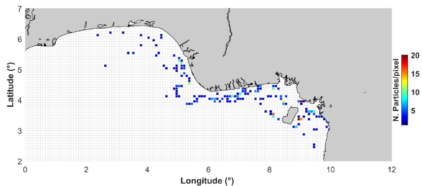
o better understand how macroplastics move and accumulate, the research team applied the TrackMPD v.1 Lagrangian hydrodynamic model, integrating Copernicus Marine Service data on ocean currents, sea surface temperature, and wind. These parameters provided the environmental forcing needed to simulate plastic trajectories, both forward (dispersion from sources) and backward (identification of origins).
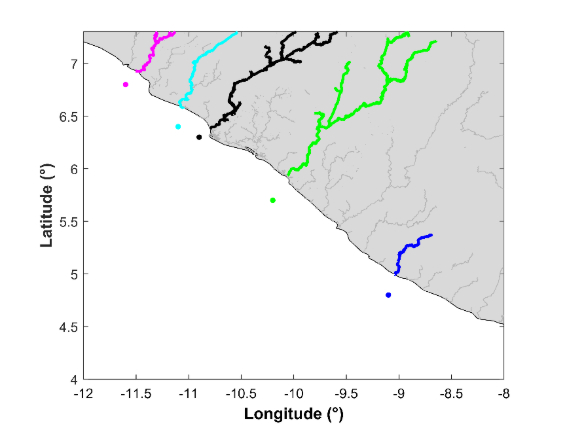
Liberia – Gulf of Guinea
Rivers such as the Mano, Lofa, and Saint John carry plastics into the Atlantic, where currents transport debris southwest toward Nigeria and Bioko Island. Accumulation hotspots were identified along the coasts of Benin and Nigeria.
Mauritania – Gulf of Guinea
Including river systems from Mauritania, Senegal, Guinea, and Liberia, the model confirmed a consistent convergence of debris into the Gulf of Guinea, reinforcing its role as a regional sink for marine litter.
Cape Verde, Mauritania, and Senegal
Backward simulations from polluted beaches in Cape Verde traced the origins of debris to Mauritania’s Arguin Basin, an area influenced by fishing and offshore oil activities. This underlines the transboundary nature of marine litter in West African waters.