Monitoring and continuously assessing seawater pollution play a pivotal role in safeguarding the well-being of marine environments, ensuring the preservation of seafood quality, and promoting the long-term sustainability of the blue economy. Such monitoring efforts are instrumental in protecting crucial marine ecosystems and conserving biodiversity by facilitating the identification and mitigation of pollution sources. By doing so, they contribute significantly to maintaining the delicate balance of coastal and ocean ecosystems, which is vital for the overall health of our planet’s aquatic habitats.
Addressing the Crucial Challenge of Marine Pollution
Plastic pollution has become pervasive in the air we inhale, the Arctic ice, our water sources, and even the fish we consume, inflicting substantial consequences on our environment, biodiversity, livelihoods, and ultimately, our well-being. The issue of plastic pollution has been exacerbated by the COVID-19 pandemic, as it has led to a surge in the use of disposable plastics and heavily strained solid waste management systems. Additionally, concerns about hygiene and the lower costs of new plastic materials have caused a decline in recycling rates. The release of plastic elements is one of the leading causes of marine pollution, which is also a growing problem. The primary sources of plastic litter found at sea are land-based: rivers, industrial plant discharges, waste dump sites, beaches, etc.
Modelling Plastic Drift and Accumulation: A Key Indicator of Water Pollution in the WACA Region
Plastic pollution presents a significant challenge to public health and food safety in West Africa. It has led to a decline in fish catch in polluted coastal lagoons within the Gulf of Guinea, a region heavily reliant on fish as a primary source of protein. Inadequate solid waste management, including plastic disposal, has been associated with an elevated risk of vector-borne diseases such as malaria and dengue fever. Africa ranks as the second-largest contributor to global plastic inputs into oceans, accounting for 7.8%, trailing only behind Asia’s 86%. Projections indicate that by 2060, Africa may surpass Asia as the primary generator of mismanaged plastic waste globally. Several West African rivers, including the Cross River, Imo River, and Kwa Ibo River, feature among the top 20 most polluted rivers worldwide.
Addressing marine plastic pollution requires comprehensive interventions across the entire plastic value chain and throughout various stages of the plastic life cycle. Initiatives aimed at bolstering solid waste management systems and combating plastic and marine pollution are underway across Africa. As part of the ESA’s Global Development Assistance programme (GDA), the thematic area on Marine Environment is dedicated to implementing innovative Earth Observation (EO) services to assess water pollution.
In collaboration with the World Bank (WB), ESA’s GDA offers valuable services that play a significant role in supporting a World Bank initiative targeting marine plastic pollution in coastal West Africa: The West Africa Coastal Areas Resilience Investment Project. Implemented within the coastal region spanning from Liberia to the Gulf of Guinea, this project employs plastic drift modelling techniques to track the movement and accumulation of plastic particles. By pinpointing the paths of these particles, this service has emerged as a critical tool for assessing and mitigating the impact of plastic pollution on the marine environment and the blue economy. Therefore, this service contributes to informed decision-making, policy development, and proactive initiatives to address plastic pollution in our oceans.
In order to ensure the adoption of this type of technologies among regional stakeholders, the WACA program is currently assessing potential complementary interventions to build capacity and transfer the knowledge related to the use of Earth Observation technologies among national and regional institutions. ESA’s collaboration with the World Bank in this field exemplifies the promising role of Earth Observation in supporting sustainable development and environmental conservation efforts.
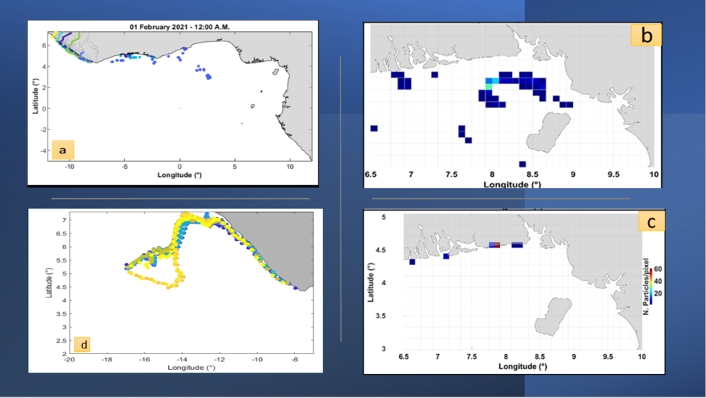
A team of researchers from the University of Palermo, as a part of a consortium led by Planetek Italia, have deployed a cutting-edge model to trace the movement of marine plastic debris within the Liberia and Gulf of Guinea area. The study focused on monitoring plastic particle trajectories stemming from the estuaries of major rivers in Liberia, over an extended period. It yielded two critical outcomes: density maps and beach maps. For instance, they enabled the comprehension of the trajectory of plastic debris discharged from Liberia’s rivers. Following a brief stay near Liberia’s coasts, these debris drift towards the Gulf of Guinea. Accumulation is observed in the coastal region between Cameroon and Nigeria, with the most significant beaching occurring along the coasts of Benin and Nigeria. These findings significantly contribute to understanding the distribution and accumulation of plastic particles in the coastal areas spanning Liberia and the Gulf of Guinea.
These results and findings were presented at the European Space Agency-ESTEC workshop on marine litter, held on October 16 and 17, 2023.

Key Takeaways
- Analysing plastic pollution pathways, accumulation zones, and density through plastic drift modelling provides valuable insights that can significantly contribute to assessing and mitigating water pollution in coastal areas.
- Numerical modelling fed by Earth Observation data allowed us to simulate impact scenarios of plastic discharged from Liberia’s major rivers. The analysis of the results confirmed that the impact of such kind of pollution is not restricted to the originator’s coastal areas of Liberia. It can reach and impact the countries of the Gulf of Guinea. This information can allow WACA partners to better interact with local decision-makers to implement actions to reduce the discharge and the impact of plastic debris.
- The extensive coverage of EO satellites and the availability of global numerical models allow it to apply the same approach to virtually any coastal area.


