Strengthening early warning for nutrition and resilience
Nigeria faces one of the most complex food and nutrition security challenges in the world. Climate variability, rising temperatures, irregular rainfall, and production shocks increasingly affect agricultural output, particularly in regions dependent on rainfed farming. These pressures translate directly into risks for food availability, nutrition outcomes, and public health, with millions of people exposed to crisis or emergency levels of food insecurity. Beyond immediate humanitarian concerns, these challenges also highlight the need for sustained development efforts, more robust institutions, and long-term resilience building within the agricultural and food security sectors.
Against this background, the Accelerating Nutrition Results in Nigeria 2.0 (ANRiN 2.0) initiative, supported by the World Bank, aims to strengthen early warning, preparedness, and response mechanisms for food and nutrition crises. As part of this effort, the ESA Global Development Assistance (GDA) programme, through its Public Health thematic activity, has demonstrated how Earth Observation (EO) can deliver timely, spatially explicit insights to support food security decision-making.
Turning satellite data into actionable intelligence
The project focused on rice production in Kano and Kaduna States, two key rice-growing areas in Nigeria. GMV, a consortium partner in ESA’s GDA Public Health thematic area, delivered Earth Observation-based services to support the World Bank in monitoring food security risks and rice production. Using freely available satellite imagery and climate data, GMV transformed EO information into practical tools that support food security monitoring and decision-making. This approach not only enhances emergency response capacities but also reinforces institutions and enables more effective, evidence-based planning processes over the longer term.
Among the main outputs, the project produced maps showing where rice is grown and developed rice yield estimates that help assess productivity and overall production levels. Together, these products offer a reliable and up-to-date overview of rice production patterns, supporting both early warning efforts and longer-term agricultural planning, while also contributing to the strengthening of resilient agricultural systems. In this way, the project contributes not only to enhanced crisis preparedness but also to broader development goals by strengthening local capacities and supporting more resilient agricultural systems.
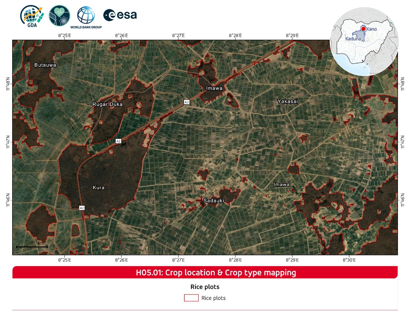
Mapping where rice is grown
Advanced satellite imagery was used to pinpoint rice fields with high precision, revealing patterns of cultivation across the region. High-resolution maps showed where rice is grown, providing a clear picture of production patterns. These maps help users understand where interventions might be needed and support planning for food security. For users and decision-makers, this means having access to detailed spatial information on the exact location and distribution of rice cultivation areas. Such geospatial insights allow authorities and development partners to clearly identify production hotspots, monitor changes in cultivated areas over time, and better target agricultural or food security interventions where they are most needed.
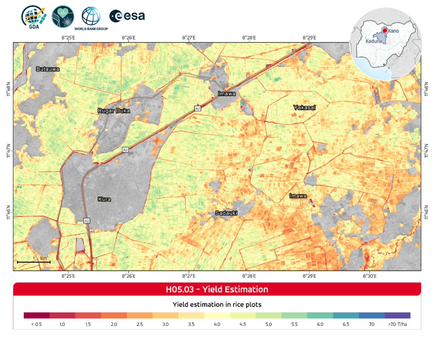
Estimating rice yields
Building on the crop location maps, the project produced rice yield estimates, offering insights into productivity and overall production levels. These estimates provide timely, independent information that complements official statistics, helping decision-makers plan and allocate resources even when traditional data is delayed or incomplete. By combining spatially detailed yield information with temporal monitoring throughout the growing season, the methodology provides users with a clearer and more comprehensive understanding of agricultural performance. This allows seasonal variations to be tracked and potential production shortfalls to be identified at an early stage, strengthening food security monitoring and enabling more informed agricultural planning.
Scalable and replicable approach
The methodology relies entirely on open satellite and climate data, making it highly adaptable and accessible. The workflows are designed to operate across diverse environmental conditions, soil types, climatic zones, and production levels, ensuring that the system can be applied in regions with very different agricultural contexts. Its scalable processing framework means that the same methods can be extended from pilot areas to state-level or nationwide monitoring without modifying the underlying workflow.
This approach can also be applied in other countries and regions, offering a practical way to integrate Earth Observation into food security, agricultural planning, and public health decision-making. By combining flexible workflows with crop-specific models, the methodology can be tailored to local cropping systems, growing seasons, and policy priorities, providing a consistent and operationally useful solution in areas with limited data. Moreover, the standardized and spatially explicit statistics on crop area and yield, can be easily incorporated into national monitoring systems, supporting informed planning, cross-ministerial coordination, and enhanced accountability.
In addition, the outputs generated through this approach have significant potential to contribute to Nigeria’s Food and Nutrition Security Preparedness Plan. The spatially consistent statistics on crop area and production, combined with regularly updated EO observations, provide a high frequency, objective and harmonized evidence base that can support continuous monitoring of agricultural conditions, early identification of emerging risks, and broader preparedness for food and nutrition security shocks. Integrating these EO-derived indicators into monitoring and preparedness systems such as the Joint Monitoring Reports (JMR), would help strengthen transparency, comparability, and timeliness in reporting on food security trends.
By delivering early and spatially detailed insights on crop distribution and expected production, EO-based monitoring can support risk assessments, contingency planning, and the prioritization of interventions in vulnerable areas. Embedding these tools within national preparedness frameworks would help governments anticipate potential production shortfalls earlier, improve cross-sector coordination, and strengthen overall resilience to climate and market shocks.
Supporting food security
By combining maps of rice fields with yield estimates, the project provides practical, data-driven information that supports stronger decision-making in food security. This information helps anticipate production risks, guide interventions, and target responses to protect vulnerable communities. Beyond immediate agricultural planning, EO-derived insights are also valuable for nutrition, health, and social protection sectors, enabling coordinated actions in response to potential food shortages, price volatility, or climate-related challenges.
The system’s capacity to deliver timely and spatially detailed information complements traditional agricultural statistics, reducing dependence on delayed or fragmented data and enabling proactive, rather than reactive, decision-making. By supporting early warning and adaptive management, it helps strengthen resilience at both community and national levels. The methodology also offers strong potential for integration with field-level observations in the future, allowing for early-season yield forecasting, which would further enhance its usefulness for policy planning, market monitoring, and risk management.