The ESA GDA AID Urban Sustainability team is working hand in hand with the World Bank’s Middle East and North Africa (MENA) Urban and Resilience team1 to provide spatial evidence supporting a Greater Amman Municipality’s strategy and plans for a productive, inclusive, resilient, and low-carbon future.
The consortium is employing Earth Observation (EO) technology for city-wide assets monitoring to construct an Agent-Based Model (ABM) to support formulation and assessment of development policy scenarios. This innovative model is fuelled by a range of EO baseline products, aimed at analysing the projected dynamics of Amman’s growth. The ultimate goal is to arm both national and city-level decision-makers with a reliable tool to guide evidence-based planning and enhance urban sustainability in Amman.
Amman’s battle plan for a climate-proof future
Amman, Jordan’s energetic heart, is proactively charting a course towards environmental sustainability. It’s not just about turning the city green; it’s about setting the groundwork for a future-proof urban ecosystem. The Greater Amman Municipality (GAM) has spent the past decade pulling out all the stops to make this a reality. And the result? Comprehensive, action-oriented initiatives like the Amman Green City Action Plan and the Amman Climate Plan.
In an exciting ESA GDA collaboration with the World Bank MENA team, GAM is a central player in the discussion on sustainable urban future. The team led a series of discussions on potential climate change challenges and developed strategies to address them effectively. The goal is clear: to build a resilient, socially inclusive city that can thrive in the face of climatic adversities.
A crucial component in this ambitious mission is to strengthen the role of geospatial data, digital tools, and institutional expertise especially in the areas of urban and transport planning and resource and asset management in adopting deeper evidence-based policymaking. This includes the incorporation of EO-based data, a key resource facilitated by the ESA GDA Urban Sustainability activity. More than just a collection of information, this data feeds a predictive tool that helps forecast how varying policy choices could steer the city’s trajectory in terms of growth, socio-economic inequalities, and long-term sustainability.
Harnessing geospatial technologies for sustainable urban planning
The company GISAT, in collaboration with the partners AIT and DLR (all members of the ESA GDA Urban Sustainability consortium led by GAF), plays a pivotal role by creating a suite of baseline products. These products, when incorporated into an Agent-Based Model (ABM), allow us to delve deeper into the projected effects on Amman’s growth, socio-economic disparities, and viability of selected scenarios:
- Land Use Land Cover (LULC): The LULC product provides historical data on land usage for the years 2010 and 2020. It combines various datasets, which are meticulously refined through human interpretation to present a detailed view of the changes in the cityscape over time.
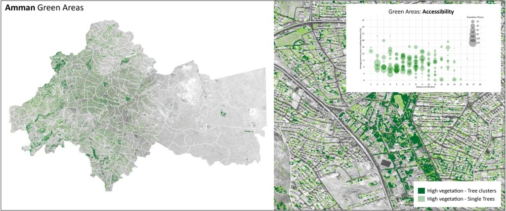
- Green Areas: Imagine having an AI-powered magnifying glass that could automatically spot every little pocket of greenery across Amman. That’s what the greenery detection tool of the ESA GDA Urban Sustainability activity does. In its current stage, this tool, with a stunning level of accuracy, marks out all vegetation in the city. And this is just the beginning, as it holds exciting prospects for future tweaks and enhancements to focus on more nuanced classifications.
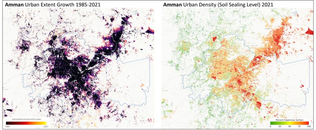
Settlement Extent and Change & Percent Impervious Surface (PIS): These unique datasets are like Amman city’s growth rings, tracing the expansion and densification trends over the years. They offer us long-term spatial patterns far beyond the city administrative boundaries, a valuable context, and a holistic view of Amman’s development, equipping us with the insights needed to plan a sustainable future. In addition, in phase 2, a novel Settlement Change Tracker has been provided on fine scale with flexible granularity up to 1 month for development hotspot identification for construction progress monitoring or land grabbing identification.
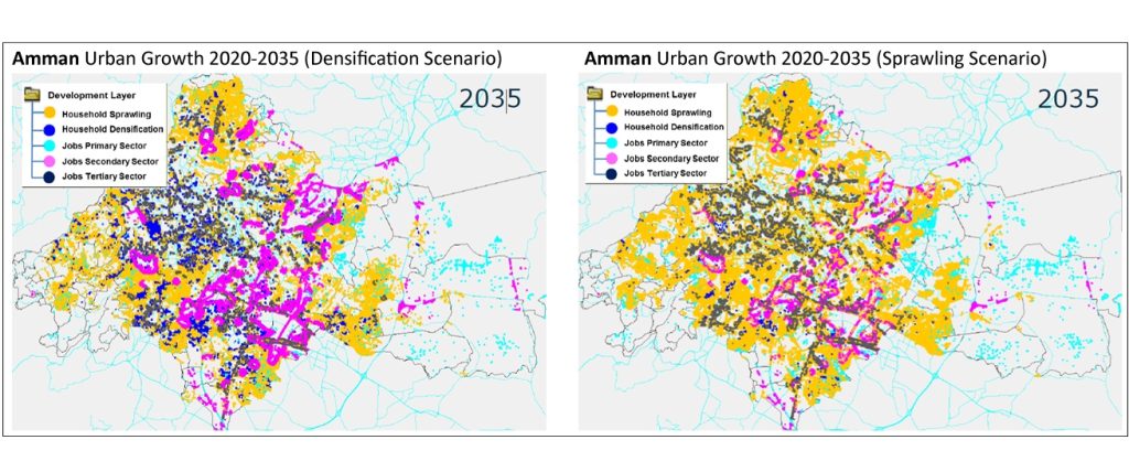
The digital toolkit doesn’t end there. The AIT’s Urban Development Simulation Model (UD_InfraSim) takes EO baseline products, a raw blueprint of the urban environment assets, combine it with other information which triggers the development (e.g. land use prices, development zones, population predictions…) and transforms it into trend analyses of future urban development. With these data-based narratives, we can play out future scenarios, testing the waters before actual implementation.
Starting with technology potential demonstrations, in the second phase of the project, ESA GDA Urban Sustainability has evolved this suite of baseline products and modelling capabilities into an enhanced and further contextualised service delivered in combination with local information and insights from local stakeholders.
EO data guiding Amman towards climate resilience
As Amman expands and transforms, it’s crucial to monitor the impacts of urbanisation on its delicate ecological balance. This is where EO data steps in, offering authorities the means to identify green space and leverage existing resources for the next generation of NBS (Nature-Based Solutions), not only for preservation but also for the prevention of the potential fallout from unchecked development.
Tools like the EO-based Urban Development Simulation Model serve as digital foresights, anticipating the city’s growth and bolstering its resilience against urban sprawl. This, in turn, shapes a more sustainable and climate-resilient Amman.
“Earth observation is a game-changer, providing policymakers with new ways to analyse and access critical spatial data and information that may not be available for many developing economies. Through ESA GDA, the program has provided a glimpse of how such methods can help countries leverage such approaches to leapfrog and address development challenges in new ways.”
Jon Kher Kaw, Senior Urban Development Specialist, World Bank
The strategies deployed in Amman offer a replicable model for other cities. In partnership with the ESA GDA Urban Sustainability consortium and the World Bank, these geospatial tools are directly integrated into the World Bank’s ongoing urban resilience agenda in Amman. The Bank is actively leveraging these tools to support the development and optimisation of the Bus Rapid Transit (BRT) system and associated transit-oriented development. This includes ongoing efforts to guide investment planning, focusing on enhancing pedestrian mobility, mitigating urban heat islands, and promoting densification along the BRT corridor. By combining data-driven scenario modeling with local insights, these activities aim to strengthen climate adaptation measures while fostering social inclusion and economic opportunities. Furthermore, the World Bank is exploring ways to scale these tools as part of a broader national initiative to enhance sustainable urban development strategies across Jordan.
In essence, Amman’s journey exemplifies how cities, in collaboration with global partners like the World Bank, can harness advanced technology to create a climate-proof and inclusive future.
The authors acknowledge for their contribution the following people: J. Kolomaznik, L. Stara, E. Orlitova (GISAT), E. Gebetsroither, K. Steinnocher, (AIT), M. Marconcini (DLR), J. K. Kaw, and H. Park (World Bank).


