Timor-Leste, an independent nation in the Indonesian archipelago, faces significant climate-related risks. The country’s agricultural sector is particularly vulnerable to extreme weather events, including erratic seasonal rainfall, tropical storms, and cyclones—many of which are intensified by El Niño and La Niña cycles, as well as climate change. These challenges have led to widespread losses in farming, damage to irrigation infrastructure, and increased vulnerability for rural communities reliant on small-scale agriculture.
The Challenge: Water Availability at Risk
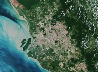
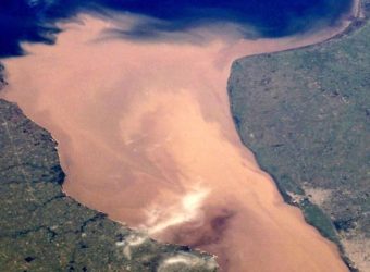
Timor-Leste’s rivers, characterised by steep gradients and short distances to the sea, experience rapid discharge, leading to flash floods during intense rainfall. With limited retention capacity and high sedimentation rates, much of the water flows away before it can be effectively used. Compounding this issue, permanent water bodies are scarce, leaving many agricultural areas at risk of drought.
Recognising the need for better water management, the Asian Development Bank (ADB) partnered with ESA’s Global Development Assistance (GDA) programme under its Water Resources thematic activity to assess surface water availability in Timor-Leste. As part of the Water Harvesting and Agriculture Value Chains Improvement Project, an ESA GDA Earth Observation (EO) Use Case was developed to detect surface water extent and variation nationwide. The activity, led by EOMAP GmbH, is delivered by a consortium of seven European firms specialising in EO, GIS, remote sensing, and development-focused technology integration.
Recognising the urgent need for improved water resource management, the Asian Development Bank (ADB) is working to assess surface water availability over time. This effort is key to understanding water scarcity, evaluating irrigation potential, and ensuring the resilience of farming communities in drought-prone regions.
Earth Observation: Unveiling Surface Water Dynamics
In a landscape where permanent water sources are rare, EO plays a critical role in tracking surface water fluctuations. By leveraging time-series analysis over multiple years, EO data provides valuable insights into the availability and persistence of water bodies.
Using satellite data from the Copernicus Sentinel mission, both optical (Sentinel-2) and radar (Sentinel-1) sensors were combined to generate reliable monthly composites. A five-year analysis (2018–2022) was conducted to account for intra-annual climatic variations and the impact of El Niño and La Niña events, which significantly influence Timor-Leste’s water cycle.
Detecting Water Scarcity Hotspots
Water scarcity remains an acute challenge in Timor-Leste, where nearly all agriculture is rain-fed and less than 10% of farmland benefits from irrigation. Rural communities frequently experience severe water shortages during the dry season as surface water sources diminish. To enhance resilience, improving the efficiency of water collection and distribution is paramount.

El Niño events, such as the one that intensified in late 2018, drastically reduced rainfall and elevated drought risks. In central Timor-Leste, small lakes like Lagua Seloi Kraik serve as critical water sources for agriculture, particularly rice farming. However, between 2019 and 2020, EO analysis revealed a sharp reduction in the lake’s minimum water extent, highlighting the growing pressure on agricultural water supplies.
Understanding the Scale of Water Fluctuations
A comprehensive analysis of surface water trends reveals alarming fluctuations in water availability. Between mid-2019 and late 2021, Timor-Leste experienced drastic shifts in surface water extent, with seasonal highs and lows ranging from a total of 30 km² to below 10 km². The significant drop to just one-third of the maximum extent underscores the fragility of water-dependent activities and the need for improved water management strategies.

Driving Impact: Supporting Decision-Making and Policy Development
Surface water dynamics analysis helps uncover environmental challenges that may not be visible on the ground but emerge through long-term EO-based observation. As such, this information directly supports the ADB in shaping Timor-Leste’s Country Partnership Strategy (CPS), guiding strategic investment in water security and agricultural resilience. This data-driven approach has reinforced the value of investing in agricultural water sustainability and helped secure funding for initiatives tackling water scarcity. Surface water monitoring also serves as a long-term reference point for ADB and government planning, informing strategies presented at high-level international forums such as climate conferences. Monitoring surface water dynamics provides a valuable long-term reference for ADB country operations and supports government investment planning. Furthermore, it informs the formulation of strategic frameworks that underpin high-level international engagements, such as climate conferences.

EO-based insights have played a pivotal role in driving urgent action among decision-makers, shaping policies at both national and international levels. To improve accessibility and foster greater engagement, a web-based platform was developed, enabling stakeholders, including government agencies and international institutions, to visualise and interact with EO-derived data. This platform enhances communication with clients, institutions, and potential partners, making satellite-based insights more understandable and actionable for non-EO experts.
Looking Ahead: Strengthening Water Resilience in Timor-Leste
By harnessing EO technology, Timor-Leste is gaining critical insight into its water resources, enabling better-informed decisions for sustainable management. As climate variability intensifies, EO-based solutions will be essential for strengthening agricultural resilience, protecting rural livelihoods, and ensuring long-term food security.