The ESA GDA Transport & Infrastructure (GDA T&I) activity is supporting the “Brazil Proactive, Safe, and Resilient Road Asset Management Program, a World Bank-led initiative. This collaboration aims to address infrastructure challenges in Brazil through the application of cutting-edge Earth Observation (EO) technologies, with a focus on sustainable development in line with the principles of zero deforestation. Officially launched in April 2024, following earlier consultations in February, the activity will use EO data to identify infrastructure vulnerabilities and prioritise sustainable investments.
This story highlights the current development of this engagement: in a nutshell, the consortium has already delivered initial results during the first iteration and is now refining and extending these outputs in the second cycle. By directly supporting the World Bank’s goals—such as reducing infrastructure bottlenecks, improving connectivity, and designing green infrastructure—GDA T&I EO services contribute to reducing deforestation.
Overcoming challenges in the Amazon
The Amazon is a globally significant ecosystem, hosting unparalleled biodiversity and playing a vital role in regulating the Earth’s climate. It is home to millions of people whose livelihoods depend on its resources. At the same time, this complex and fragile ecosystem is under significant pressure. One of the greatest challenges is deforestation, driven by the demand for bioeconomic products and services. Additionally, climate change is taking its toll. The Amazon presents unique challenges for infrastructure development due to its immense size, seasonal hydrological variations, and remote locations. Traditional mapping and monitoring methods often prove inadequate, as they are costly and can become outdated quickly.
The WB project aims to promote sustainable development by increasing economic opportunities, enhancing living standards, and expanding the bioeconomy while preserving the rainforest and adhering to zero-deforestation principles.
It focuses on three key activities:
- Identifying infrastructure bottlenecks: Analysing obstacles to productivity growth, particularly those hindering the development of bioeconomy value chains.
- Improving connectivity and access: Addressing challenges in accessing basic services and fostering inclusivity, aligned with the Sustainable Development Goals (SDGs).
Designing a green infrastructure roadmap: Developing sustainable solutions for transport, energy, and digital connectivity with a focus on renewable energy and waterway utilisation.
Leveraging Earth Observation for Infrastructure Solutions
To address these issues, the World Bank has turned to EO to assess infrastructure vulnerability and identify priority areas for intervention.
The ESA GDA T&I team, in partnership with e-GEOS and IABG, is using EO to monitor and model the Amazon’s complex landscape. This engagement officially began in April 2024, following a preliminary meeting with the World Bank team in February to assess project requirements. Currently, the consortium is in the second iteration of the GDA agile cycle, having already delivered initial results and now focusing on refining them. Results from this engagement are expected to evolve with each cycle, ensuring timely and actionable insights.
High-resolution satellite data, particularly from ESA Sentinel-1 and Sentinel-2, provides up-to-date and accurate insights into critical areas such as waterway navigability, seasonal changes, and infrastructure vulnerability. Key components of the analysis include:
- River flood modelling: Flood modelling in areas like Leticia, Colombia, highlights infrastructure vulnerability due to geographic proximity to rivers, deforestation, and insufficient drainage. Potential flood extent and depth, modelled for different return periods (50, 100, and 500 years) provide critical insights to inform mitigation strategies, such as improved drainage systems and sustainable land-use practices.
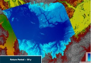
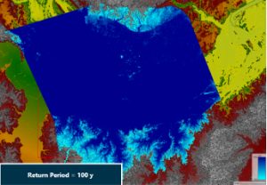
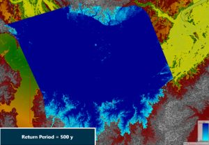
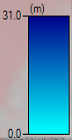
– Figure 1: Flood Extent and Depth for the Three Selected Return Periods of 50, 100 and 500 Years
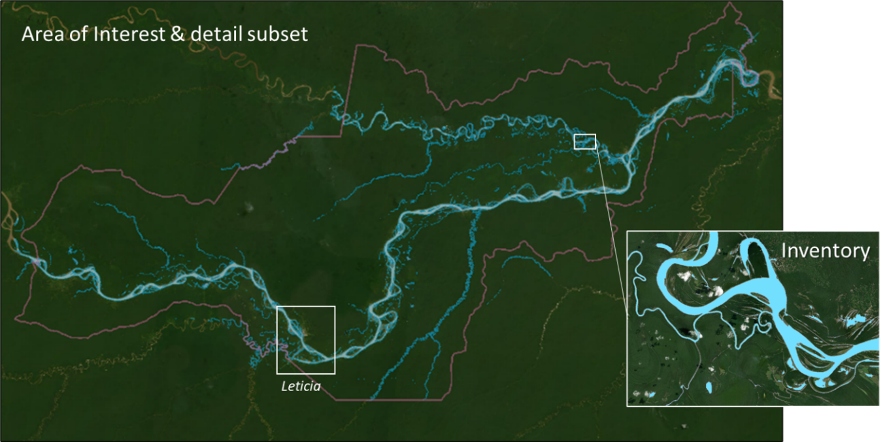
- Hydrographic inventory: A comprehensive inventory of the Amazon’s river network was created using optical Sentinel-2 satellite imagery collected during the dry season (July–November 2024). Sentinel-1 radar data was used optional and as a back-up to supplement heavily clouded areas. Various indicators taking advantage of the broad spectrum of S 2’s spectral bands were used to classify river networks and assess navigability. Incorporating advanced AI technologies will further enhance the accuracy and detail of this inventory, particularly for smaller and narrower waterways.
- Seasonal and long-term waterway changes: Changes in watercourses were analysed using EO data by comparing high-resolution optical imagery from Sentinel-2 across multiple years. Sentinel-1 radar data was used optional and as a back-up to supplement heavly clouded areas. Seasonal variations were captured by comparing imagery from dry and wet seasons, while long-term changes in riverbeds were assessed using the Global Surface Water Layer dataset (1984–2021). These insights help understand the geomorphological variations and sedimentation affecting navigability.

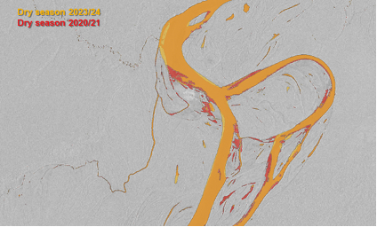
– Figure 3: Change in Water Extent During Dry and Wet Season Between 2020/21 and 2023/24
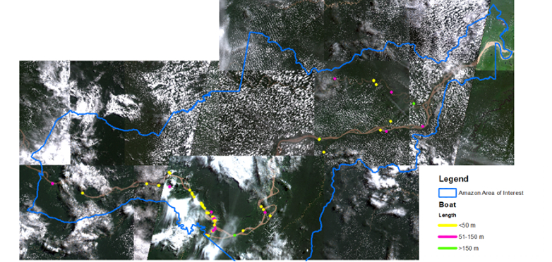
- Boat detection: Satellite-based boat detection using Sentinel-1 radar as well as Sentinel-2 optical imagery of the year 2024 offers valuable insights into the usage of waterways for transportation. An analysis of the Letícia area identified varying levels of boat traffic over different dates. Higher-resolution imagery is recommended to improve monitoring accuracy and is planned to be examined in the second development cycle.
Ultimately, each of the WB’s three key activities aligns with and benefits from the EO-driven insights provided by ESA. For example, addressing infrastructure bottlenecks directly connects with ESA’s flood modelling and hydrographic inventory, enabling the identification of vulnerable areas and informing targeted interventions. Similarly, improving connectivity and access is bolstered by seasonal and long-term waterway analyses, which highlight navigability issues critical to supporting bioeconomic value chains. Lastly, designing a green infrastructure roadmap benefits from the integration of EO-based data into the planning of sustainable transport and energy solutions, such as optimising waterway utilisation and monitoring human activity like boat traffic. By combining these efforts, the collaboration ensures a cohesive approach to reducing deforestation while fostering a thriving bioeconomy.
Pioneering a zero-deforestation future
The World Bank’s collaboration with the ESA GDA T&I team exemplifies how EO can bridge critical gaps in infrastructure development, particularly in remote and ecologically sensitive regions like the Amazon. By addressing the World Bank’s goal of increasing productivity through infrastructure development while preserving standing rainforest, EO-derived products such as flood modelling, watercourse change analysis, hydrographic inventory and boat detection directly support zero deforestation goals. These services help identify transport bottlenecks, prioritise sustainable waterway use and mitigate climate risks, ensuring that infrastructure planning minimises environmental disruption.
By using state-of-the-art EO data and engaging stakeholders and local communities, the GDA T&I activity takes a comprehensive approach to addressing infrastructure vulnerability and climate risk. It aims to scale up developments demonstrated in Leticia, Colombia—such as identifying key flood-prone areas and promoting sustainable land use—to other hotspot areas across the Amazon. These efforts will ensure that the bioeconomy thrives while maintaining the principles of zero deforestation, ultimately bringing higher incomes, better productivity and improved living standards to the people of the Amazon.
The World Bank team confirmed that the EO products would be included in a forthcoming flagship report on Amazon infrastructure to be presented at the COP 2025. They noted that the EO work was a useful complement to traditional consultancy efforts, helping to inform both regional analysis and methodological guidance for future use. Given the team’s high level of engagement and clear strategic focus, there is strong potential for the continued use of EO products in the project.