










Digital systems are transforming how societies identify individuals, transfer money, and exchange information. Yet an equally important dimension is place. Without geospatial data, digital systems capture who and what but not always where, leaving some communities invisible within the data that guides policies and services.
This blog post explores why geospatial data, and particularly satellite Earth Observation (EO), should be recognised as a foundation of Digital Public Infrastructure (DPI), instead of as an external system. It argues that integrating EO within DPI fills a critical spatial gap in policy making and strengthens each of DPI’s core components: digital identity, payments, and data exchange.
The shift towards digital public infrastructure
Over the past decade, international development institutions have placed Digital Public Infrastructure (DPI) at the centre of their digital development agendas.
The 2025 World Bank (WB) report Digital Public Infrastructure and Development: A World Bank Group Approach describes DPI as a foundation for inclusion, resilience, and economic opportunity, calling for integrated investments in interoperable digital systems that operate as public goods.
The Asian Development Bank (ADB) takes a similar approach, positioning DPI at the heart of digital transformation and estimates that effective DPI can reduce administrative costs by up to 50 percent and expand financial inclusion by up to 60 percent, making governance both more efficient and more equitable.
The agenda extends beyond the multilateral development banks. The Global Digital Compact, adopted by 193 member states in September 2024, recognises DPI as a route to inclusive digital transformation and to the Sustainable Development Goals (SDGs), and the UN Office for Digital and Emerging Technologies (ODET) and the United Nations Development Programme (UNDP) have since released the Universal DPI Safeguards Framework to guide safe and inclusive implementation. Philanthropic funders are moving in the same direction: the Gates Foundation has committed US$200 million to expand DPI globally, covering interoperable payment systems, digital identity, data sharing, and civil registries.
These institutions converge on a shared view: DPI is not a single technology but a set of shared foundations, a layer of interoperable digital systems built around three core components: digital identity, which creates and authenticates unique identities; digital payments, which let governments, businesses, and individuals send and receive money; and data exchange, which lets organisations securely share information. Each of these components becomes more powerful when it is geo-enabled: when base registries of people, businesses, and land carry standardised location attributes, location becomes the common reference key linking people, land, assets, and services across otherwise siloed systems.
Together these make public services more transparent, accessible, and responsive. Yet, for all their reach, these systems often lack a complete picture of where people live, where assets are, or which areas are most at risk, the spatial gap that satellite EO can fill.
How EO strengthens DPI
Satellite EO is the use of satellites to gather information about the land, water, and infrastructure below. EO gives objective coverage across both space and time: the same sensor collects comparable data everywhere, and because the satellites stay in orbit for years they show gradual change rather than a single snapshot. For governments this means a consistent and up-to-date picture of an entire territory, including places that are difficult or costly to survey on the ground.
EO already functions as a Digital Public Good; an openly accessible, interoperable resource that supports inclusion, innovation, and transparency. Open missions such as Copernicus, with a €5.42 billion budget, provide full, free and open imagery and analysis tools to governments worldwide, and the ESA GDA programme takes this further by embedding EO services within real development operations.
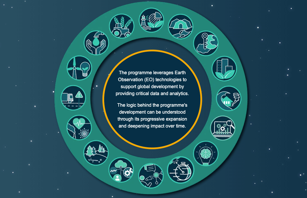
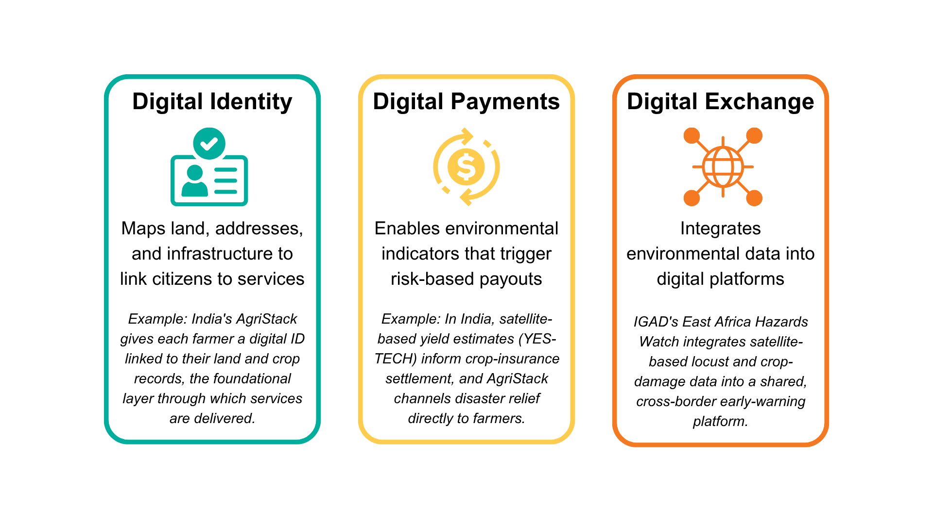
EO becomes part of DPI through three practical mechanisms, each already visible in countries doing it: by aligning around shared standards so geospatial data interoperates across agencies and borders; by consolidating it into a shared national resource base that other sectors can build on rather than letting institutions duplicate it; and by treating it as a foundational data layer for service delivery rather than a sectoral add-on. Together, these mechanisms embed geospatial capabilities across every layer of the DPI and services stack — from geo-enabled base registries, through standards-based data sharing, to location-aware service delivery — shifting governments from siloed registries towards data-driven, integrated service delivery, and AI for services. The diagram below shows how, in turn, this strengthens DPI’s three core components.
1. Shared standards and interoperability
Integrating EO into DPI does not require starting from scratch. Many countries already have a National Spatial Data Infrastructure (NSDI), a national system designed to manage, share, and govern geospatial data across institutions, and NSDI is increasingly recognised as part of the broader DPI family. The common scaffolding for this is the UN’s Integrated Geospatial Information Framework (IGIF), which gives agencies and countries a shared basis for standards and governance so that their data can actually interoperate. In practice, this means reconceptualising the NSDI not as a standalone technical initiative but as an integral component and building block for DPI and integrated service delivery, and adopting open standards and APIs — such as those of the Open Geospatial Consortium (OGC) and Open Earth Observations (OpenEO) — so that data produced by one agency can readily be used by others and location can serve as a common join key even where identifiers differ.
In East Africa, the Intergovernmental Authority on Development (IGAD) shows what this looks like at a regional scale. Through the ESA GDA Agriculture activity and developed by VITO, IGAD integrated EO-based locust monitoring and cropland damage assessments into its East Africa Hazards Watch platform, a publicly accessible early warning system used by governments, international organisations, and risk managers. As a shared regional platform, it gives several countries a shared view of emerging agricultural threats across borders, so that national agencies work from the same continuously updated spatial evidence base rather than separate ones.

2. A shared national resource base
The second mechanism is consolidating geospatial data into a shared national resource base, exposed through open APIs, rather than letting each institution procure and hold its own. The point is not a single portal but one authoritative set of geospatial layers that other sectors, schemes, and service providers can integrate into their own systems. Rwanda’s GeoHub, developed by the Rwanda Space Agency with support from the Agence Française de Développement (AFD), is a strong example. It functions as a centralised, interoperable platform that aggregates satellite imagery, government datasets, and analytical tools into a shared national system, organised into thematic layers covering land use, crop distribution, and environmental conditions, with access for institutional users including government bodies and, increasingly, financial institutions. By turning EO into usable insight such as crop-type mapping and pre-harvest yield prediction, it supports evidence-based public services while ending the costly duplication of institutions separately procuring satellite imagery. In late 2025 it became, in the government’s words, the first national near-real-time geospatial platform for agriculture in Africa to be operationalised. This is the multiplier effect of using geospatial infrastructure to enable advancements in digital service delivery: a single investment can simultaneously power flood forecasting, urban planning, agricultural advisories, and disaster risk management.
3. A foundational layer for public and private services
The third mechanism is treating geospatial intelligence as a foundational layer in national digital systems rather than a sectoral add-on, so that the tools used to plan and deliver services, whether run by government or by regulated private providers, carry spatial evidence by default. Service logic often depends on where: eligibility and delivery can hinge on distance to a facility or presence in a risk zone, so services designed on spatial evidence reach people faster and more fairly. The same layer serves private delivery where access is opened to it: in Rwanda, GeoHub users now include financial institutions alongside government bodies, and in India satellite-based yield estimates feed a national crop insurance scheme operated with private insurers.
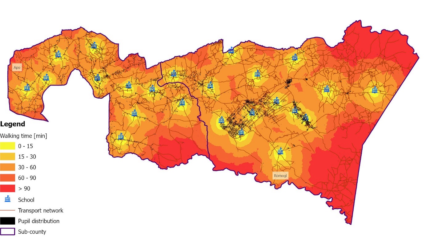
In Uganda, the ESA GDA Transport & Infrastructure activity supports the WB’s Uganda Secondary Education Expansion Project, which aims to expand access to lower secondary education. IABG and DLR combined satellite-derived settlement and population layers (built from Sentinel-2 imagery and census data) with transport networks, land cover, and terrain to estimate how long it takes pupils to reach the nearest school. In a country where about half of all journeys are made by non-motorised transport and secondary pupils are expected to walk up to 5 km, roughly an hour each way, this reveals which communities sit beyond a reasonable distance from any school, and pinpoints where new schools or alternatives such as school transport would help most. These spatial insights feed directly into the national education planning system the government uses to target investment, so the planning tools that decide where schools are built now carry spatial evidence about where pupils actually are.
India shows the same mechanism at national scale. EO is being integrated into the DPI underpinning the Digital Agriculture Mission, through the national farmer and land-parcel registries (AgriStack) and the Krishi Decision Support System (KDSS). The KDSS draws on satellite imagery, weather, soil and crop data to generate digital crop maps, yield estimates, and drought and flood monitoring, while AgriStack gives each farmer a digital identity linked to their land and crop records; the identity layer on which services are delivered. Satellite-based yield estimation feeds the national crop insurance scheme directly: under YES-TECH, remote-sensing and AI analytics produce yield estimates that carry at least 30% weight in insurance settlement, speeding up claims. The same digital infrastructure accelerates relief: during the 2025 monsoon-season (Kharif) crop losses, Maharashtra used AgriStack to transfer over 140 billion rupees (about US $1.5 billion) to 8.9 million farmers. India is now formalising this approach: its National Geospatial Policy explicitly positions location data as part of the country’s digital public infrastructure, with liberalised data access and a unified interface for publicly funded geospatial data.
From parallel systems to spatially aware digital infrastructure
Digital and geospatial systems have evolved along parallel paths, despite sharing the same design values: openness, interoperability, trust, and inclusion. Bringing them together unlocks the greatest value. Across the cases above, the route is consistent: align around shared standards, geo-enable the core registries of people, businesses, and land, consolidate data into shared platforms, and treat the spatial layer as foundational rather than optional. Countries can follow this route progressively, whatever their starting point: beginning with foundational access to open EO data, moving to geo-enabled registries and standards-based data exchange, and advancing towards AI-ready data repositories and digital twins for simulation, planning, and crisis response. The World Bank’s emerging approach to geospatial for integrated service delivery follows the same logic, combining a progressive maturity model with financing and partnerships that connect governments with space agencies such as ESA. The ESA GDA programme already demonstrates this in practice, embedding EO within real development operations to show that spatial data is not an add-on but a foundation for more inclusive and evidence-based development.
Who builds and governs this layer matters as much as the data in it. The geospatial layer is typically run by a national mapping or space agency, as GeoHub is by the Rwanda Space Agency, under the standards and institutional arrangements set out in the IGIF, with development partners such as ESA and AFD supporting the build rather than owning it. The governing principles are the ones the Universal DPI Safeguards Framework applies to the rest of DPI: openness, interoperability, accountability, and inclusion by design. Value then compounds where access is opened through APIs, so that ministries, researchers, and private providers can build their own services on the shared layer instead of waiting for one agency to meet every need.
As digital transformation accelerates, integrating EO within DPI offers a path toward spatially aware digital infrastructure: systems that connect data with geography, inclusion with visibility, and technology with the realities of people and place.