The ESA Global Development Assistance (GDA) Transport & Infrastructure (T&I) activity is contributing to the World Bank-led Angola Urban Sustainable Mobility Project, which aims to enhance transport infrastructure in Angola’s secondary cities. Launched in April 2024, the collaboration harnesses open-access Earth Observation (EO) data to bridge critical information gaps in road networks, monitor urban expansion, and assess transport accessibility.
This story highlights the latest developments of the collaboration. The first development cycle has provided key insights, and the team is now refining and expanding the analysis. By improving connectivity, reducing infrastructure gaps and improving data-driven planning, ESA GDA’s T&I EO services are helping to build more efficient and resilient urban mobility in Angola.
Angola’s urban growth is overloading the country’s transport infrastructure
Angola has experienced rapid urbanisation, with nearly 70% of the population now living in cities, often in an informal and unplanned manner. This has led to significant transport and mobility problems, particularly in secondary cities such as Lubango, where informal road networks have developed organically rather than being systematically planned. Poor connectivity within and between neighbourhoods means that residents, especially those on the urban periphery, struggle to reliably access essential services such as markets, schools, and health facilities.
A major obstacle to improving transport planning in Angola is the lack of detailed data on the country’s 76,000 km road network. Almost half of this network remains poorly mapped or characterised, preventing effective prioritisation and targeted infrastructure investment.
To address these transport and mobility challenges, the World Bank, in partnership with the Angolan Ministry of Transport, is preparing a comprehensive urban mobility project for secondary and tertiary cities. A key objective of the current identification phase of the project is to improve the understanding of existing transport infrastructure, urban growth patterns, and accessibility constraints.
Mapping roads and growth with EO satellite data
To support World Bank efforts, the ESA GDA T&I consortium, in collaboration with CLS and IGN-FI, is monitoring and analysing Lubango’s urban and transport landscape using satellite EO data. This work started in April 2024, following an initial requirement meeting with the World Bank team in February. Currently, the consortium is refining its analyses following the first round of results and preparing to deliver final results in the ongoing agile ESA GDA cycle.
Using high-resolution ESA Sentinel-2 imagery, the consortium has delivered EO-driven analyses focusing on:
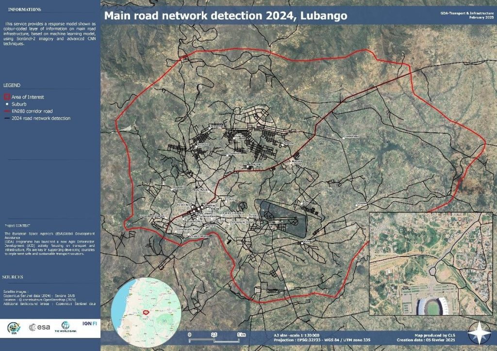
- Road network inventory (2024): Sentinel-2 imagery was used to produce an updated map of main and secondary roads. The analysis was based on existing OSM data, complemented by AI algorithms for road detection, filling critical data gaps in rural and peri-urban areas.

- Travel time estimation: Based on the road network inventory, this analysis estimated travel times (by car and on foot) from key locations such as marketplaces and schools to surrounding (peri-urban areas. It estimated speed to highlight potential accessibility gaps for the local population to these basic infrastructure elements. Crossing travel time data with urban characterisation (described below) give more precise information about the estimated travel time between point of interest to residential area.


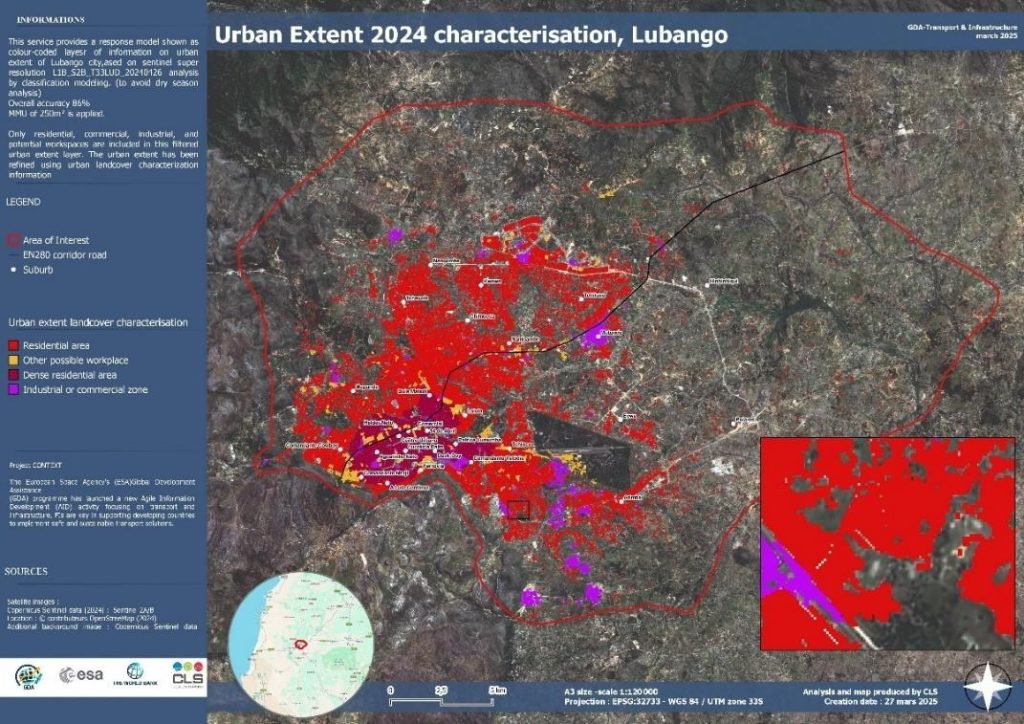
- Urban extent and growth mapping (2016-2024): Sentinel-2 data tracked Lubango’s urban growth over eight years, mapping unplanned urban expansion patterns. This enables planners to anticipate future infrastructure needs in newly created urban conglomerates.

- Urban characterisation: The urban extent has been categorised into four main classes to identify residential areas, commercial and industrial distributions, and major workplaces. This data refines the information regarding the distribution of workplaces and residential zones. Combining this data with other layers such as travel time allows to refine the information on areas of interest and allow a better understanding of accessibility or mobility patterns
- Road network change detection (2016-2024): This comparison of road networks over eight years revealed infrastructure expansion or stagnation. By combining the network analysis with the analysis of urban extent and growth, it provides key information data for strategic investment decisions to improve and balance urban connectivity in line with urban growth.
The results were shared through the consortium’s interactive data visualisation platform provided by IABG, enabling users to explore selected data layers, customise visualisation scales, and navigate intuitively across the mapped area, greatly facilitating interpretation and engagement with the data

Securing EO knowledge to guide infrastructure investments and sustainable planning
The World Bank’s experience in Lubango has clearly demonstrated the value of satellite-derived EO insights in addressing Angola’s urban mobility challenges, particularly in areas where traditional mapping methods are insufficient. The EO products developed by the ESA GDA consortium, including a detailed road network inventory, precise travel-time estimations, comprehensive urban growth mapping, and road network change detection, provide essential data to help planners anticipate infrastructure needs, identify connectivity gaps, and strategically guide future investments.
In the coming months, the ESA GDA T&I consortium will complete these analyses, refining road network data through integration with urban extent maps, finalising travel-time calculations, confirming critical locations such as schools, and further developing urban growth and road-change insights. Ensuring the sustainable use of these analyses will be critical; thus, next steps involve working closely with the World Bank team and Angolan authorities to maintain continuous access to EO data, integrate these resources into an accessible visualisation platform, and explore ways to build local capacities. This capacity building may include technical training, providing GIS software and necessary licences, and documenting methodologies clearly to enable replication across other Angolan cities, aligning with the shared interests of the World Bank and the Angolan government in fostering a connected, resilient, and sustainable urban future.