









Satellite data helps monitor damage and reconstruction of health facilities where access on the ground is difficult
Explore the GDA Health impact stories now on the Impact Sphere.
Armed conflict leaves lasting scars on communities, often destroying the hospitals and health facilities that people depend on most. Yet once the fighting stops, governments and development partners face a difficult question: where should reconstruction begin, and how can progress be monitored over time?
In fragile and conflict-affected environments, field assessments can be slow, costly, or impossible due to security constraints. This limits the availability of reliable information needed to prioritize investments and restore essential health services.
Through the European Space Agency’s Global Development Assistance (GDA) programme, the Public Health thematic activity is demonstrating how Earth observation (EO) can provide objective, timely and scalable evidence to support post-conflict reconstruction.
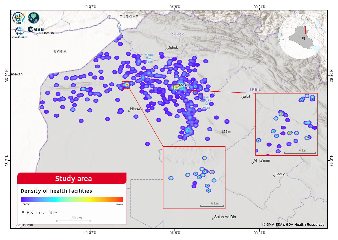
Working with the World Bank Group, the project has developed and tested satellite-based methods to assess conflict-related damage and monitor the long-term reconstruction of health infrastructure in Mosul, Iraq.
Seeing the impact of conflict from space
Mosul experienced some of the most severe destruction during the 2014–2017 conflict with the Islamic State. Hospitals and healthcare facilities suffered extensive damage, severely disrupting access to essential services precisely when communities needed them most.
Traditional damage assessments rely heavily on field surveys and manual interpretation of very high-resolution imagery. While these approaches provide valuable information, they are often resource-intensive and difficult to repeat regularly across large areas.
The GDA project explored how Sentinel-1 radar satellite data can complement these methods by providing regular, repeat observations regardless of cloud cover, weather conditions or daylight. Using nearly a decade of satellite observations, from 2015 to 2025, the project generated objective indicators of both structural damage and subsequent reconstruction.
Mapping damage across an entire city
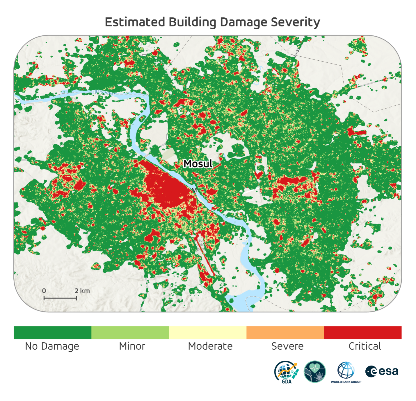
The first EO service developed within the project focuses on city-scale building damage assessment.
Using a statistical change-detection technique applied to Sentinel-1 Synthetic Aperture Radar (SAR) imagery, the service automatically identifies locations where statistically significant changes in the radar signal are associated with potential structural or land-surface changes between pre-conflict and post-conflict periods. The results indicate areas that may have experienced change but do not, by themselves, provide a detailed assessment of the damage affecting individual buildings.
The resulting damage maps clearly highlight the concentration of destruction across Mosul. The highest levels of damage are consistently identified in the city’s historic Old City and surrounding western neighbourhoods, while eastern districts show comparatively limited impacts.
The satellite-derived results show broad spatial agreement with independently produced UNOSAT damage assessments based on very high-resolution imagery, providing an encouraging indication that radar-based approaches can complement more detailed manual damage mapping and support repeatable monitoring over larger areas.
Rather than replacing existing damage assessments, EO offers an operational capability that can rapidly identify priority areas for reconstruction while reducing the need for extensive manual mapping.
Looking beyond damage to reconstruction
Understanding where buildings were destroyed is only part of the picture.
Equally important is understanding how reconstruction unfolds over time.
To address this challenge, the project developed an innovative and exploratory methodology to monitor the reconstruction of individual health facilities using long-term Sentinel-1 time series.
Instead of producing a single damage map, satellite observations were analysed continuously over ten years to detect changes in the radar signal associated with structural collapse, debris removal and rebuilding activities.
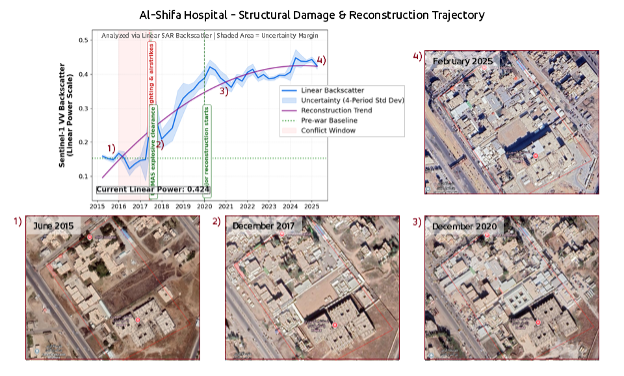
The approach generated long-term radar trajectories for several key hospitals in Mosul, allowing analysts to explore patterns of structural change associated with both destruction and reconstruction.
At several facilities, including Al-Shifa Hospital, Ibn-e-Sina, Al-Salaam Hospital and Ibn-el- Atheer, changes in the Sentinel-1 radar signal over the post-conflict period are broadly consistent with structural reconstruction and development observed in independent imagery. This exercise showed the potential of long-term satellite observations to track physical changes at health facility sites and provide complementary information on how reconstruction evolves over time.
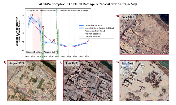
The same approach can also capture trajectories dominated by destruction and clearance. At the Al-Shifa Complex, a pronounced decrease in the radar signal is broadly consistent with the extensive destruction and subsequent removal of damaged structures visible in independent imagery. The signal remains substantially below its pre-conflict level throughout the following years, in line with the limited rebuilding observed across much of the original complex by 2025. This emphasizes the potential of EO to track not only reconstruction, but also persistent structural loss where reconstruction remains limited.
The methodology remains exploratory, as changes in radar backscatter cannot always be directly attributed to damage or reconstruction and require supporting information for interpretation. Nevertheless, the results demonstrate the possibilities of long-term satellite observations to complement conventional reconstruction assessments where ground-based information is limited.
Supporting better reconstruction decisions
For organisations involved in rebuilding critical infrastructure, having access to consistent and up-to-date information is essential. Importantly, physical reconstruction should not be interpreted as equivalent to restoration of health services. A facility may be structurally intact but remain partially or fully non-operational because of constraints related to staffing, equipment, utilities, supplies or accessibility. EO therefore provides an infrastructure-level evidence layer that can be combined with health-sector and administrative data to assess broader service restoration.
The EO products developed through this GDA activity provide decision-makers with:
- spatial evidence on the location and relative intensity of conflict-related infrastructure damage;
- a basis for prioritising facilities and locations for detailed field assessment or rehabilitation planning;
- repeatable monitoring of physical reconstruction progress where ground-based verification is difficult; and
- an independent geospatial evidence layer that can complement administrative, health- sector and project monitoring data.
Because the methodology relies primarily on freely available Sentinel-1 data, it also offers a cost-effective solution that can be updated as new satellite acquisitions become available.
Building a foundation for future applications
While the Mosul case study served as a pilot, the methodology has been designed with broader applicability in mind.
The building damage workflow can be adapted to other conflict-affected cities or regions, provided that local calibration and validation data are available. Likewise, the health facility monitoring approach represents an important proof of concept for using satellite time series to understand long-term reconstruction of critical infrastructure.
The project also highlights areas for future improvement. Increasing the availability of independent validation data, integrating additional Earth Observation sources, and refining time-series analysis techniques will further strengthen the operational value of these services.
Earth observation for more resilient health systems
This GDA Public Health case study demonstrates that satellite data can support activities far beyond emergency response.
A longer-term opportunity is to develop a geospatial framework for monitoring health infrastructure in FCV settings. By combining EO-derived indicators with health-facility inventories, population and accessibility data, conflict information, and administrative health data, future applications could assess infrastructure damage, its impact on access to essential services, and where reconstruction or further assessment should be prioritised. The Mosul case study provides a foundation for adapting this approach in other FCV contexts.
By delivering objective, repeatable information on damage and reconstruction, EO can support more informed planning, transparent investment decisions, and resilient health systems—particularly where access is limited and reliable information is scarce.