The European Space Agency (ESA) Global Development Assistance (GDA) Climate Resilience Consortium has partnered with the Asian Development Bank’s (ADB) Improved Coastal Management and Coastal Protection team to support Georgia’s National Ministry for Regional Development and Infrastructure. Utilising EO data, the GDA consortium conducted a thorough vulnerability assessment of Georgia’s Black sea coast.When designing infrastructure, it is crucial to consider the impacts of climate change to ensure that infrastructure can withstand not only today’s extreme events but also the increasingly severe and frequent climate-related impacts that countries like Georgia will face in the future.
Georgia’s infrastructure is at significant risk of flooding from both inland sources such as rivers and heavy rainfall events, as well as from coastal flooding along the Black Sea coast. The ADB is working to enhance resilient infrastructure design in Georgia for all types of infrastructure, particularly urban areas, by assisting the Ministry of Regional Development and Infrastructure in establishing design codes that consider climate change. Assessing the vulnerability of existing infrastructure to flood risks is essential for effective resilience planning and for developing new design codes for future projects.
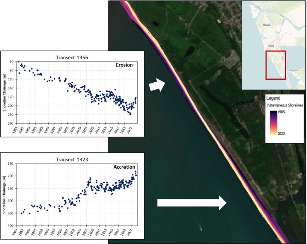
Inset plots illustrate changing rates of shoreline position through time at two different locations. This high temporal frequency analysis allows shifts in the rate of shoreline change to be better constrained (e.g. in the lower plot, transect 1323 shows an increasing rate of accretion up to 2008 where the shoreline appears to shift to a slight erosional trend before switching back to accretion ca 2015). Changes may correlate to storm events, construction of coastal infrastructure, changes in sediment supply or a range of processes. Where detailed analysis has been undertaken along the coast, high temporal frequency shoreline changes have been derived at ca. 50 m intervals.
In collaboration with the ADB, the consortium adapted CoastSat—an open-source coastal mapping tool—by integrating data from satellites (Landsat and Sentinel) to monitor shoreline changes over the past 40 years. This approach is invaluable as manual field surveys are often insufficient to understand the baseline conditions of coastal zones. Access to open data, including EO data, can significantly contribute to developing effective coastal zone management strategies.
The analysis provided vital information on the dynamic morphological conditions in the study area. Using this data, the vulnerability assessment identified hotspots susceptible to severe erosion, considering factors such as nearby coastal infrastructure and prevailing meteorological and oceanic conditions. This information has laid the foundation for the Georgian government’s coastal management planning, enabling the identification of areas best suited for various types of interventions.
JBA Consulting, a member of the GDA Climate Resilience thematic activity, has been awarded a follow-up project in Georgia by the ADB. This project aims to develop a modelling suite for the Ministry of Regional Development and Infrastructure of Georgia to fulfil its coastal management mandate. The JBA team has designed and will deliver a modelling tool to determine littoral transport rates and the resultant changes in shoreline position over time. This tool will be instrumental in developing shoreline protection concept designs, aiding Georgia in managing and protecting its coastal areas effectively.
Learn more about how ESA’s earth observation data has been used for flood risk and coastal change projects here.
Key Takeaways
- Georgia’s Black Sea Coast faces high vulnerability to climate change. Urgent actions are necessary for resilience and adaptability.
- Earth Observation data, integrated through CoastSat and satellite missions like Landsat and Sentinel, enables accurate shoreline tracking, which is vital for effective coastal management.
- The information provided by the consortium laid the groundwork for the Georgian government’s coastal management plan by providing insight into the climate risks the Back Sea coast faces.
ESA’s GDA Programme is a global partnership implemented with key International Financial Institutions (IFIs) – World Bank and Asian Development Bank – to mainstream the use of Earth Observation (EO) into development operations. For more information, please visit our website: https://gda.esa.int


