The ESA GDA Transport & Infrastructure (GDA T&I) activity is supporting the World Bank’s Enhancing Connectivity in Northern Guinea-Bissau Project to better understand mobility patterns, assess infrastructure vulnerability, and identify where and how investments in transport infrastructure can be most impactful. This collaboration focuses on the use of satellite-based Earth Observation (EO) to fill critical data gaps and inform strategic decision-making in a fragile, climate-vulnerable context.
This case study is part of the GDA T&I consortium’s broader work to support IFI teams with innovative, user-tailored EO services. In Guinea-Bissau, the focus is on building a clearer picture of road conditions, border and port activity, and climate-related transport risks.
Overcoming infrastructure and climate challenges in Guinea-Bissau
Guinea-Bissau’s transport system remains underdeveloped for national needs. Of the 2,700 km of classified roads, only 800 km are paved, and many are in poor condition. Maintenance efforts are hindered by a lack of data, limited financing, and institutional instability. With no existing inventory of feeder roads or bridges, the government struggles to prioritise investments.
Meanwhile, the country faces increasing climate threats, such as sea level rise, salinisation, and seasonal flooding, which further degrade already fragile transport routes. The World Bank team supporting the country has identified a pressing need to monitor these impacts and understand how infrastructure performance intersects with population density, trade flows, and resilience priorities.
The GDA T&I collaboration in Guinea-Bissau builds on these needs and aims to deliver EO-based insights to guide strategic planning.
The EO focus: monitoring transport activity and exposure to climate risks
The ESA GDA T&I Use Case team, led by SpaceKnow, with contributions from DLR and IABG, has deployed EO services to monitor port and border activity, characterise traffic presence along key corridors and map climate exposure.
SpaceKnow applied analytics to Sentinel-1 Synthetic Aperture Radar (SAR) data to detect metallic objects—such as trucks, cars, and containers—across the country’s key roads and ports. This approach enables consistent monitoring regardless of cloud cover and has revealed congestion hotspots and fluctuations in cargo activity. The analysis revealed:
- A peak of over 1,000 m² of vehicle presence at the São Domingos border in July 2024
- Moderate vessel activity at the port of Bissau, with up to three ships docked simultaneously
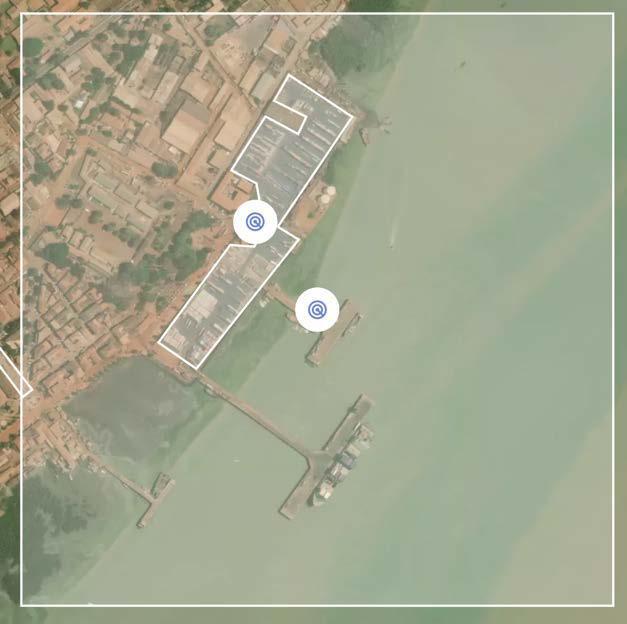
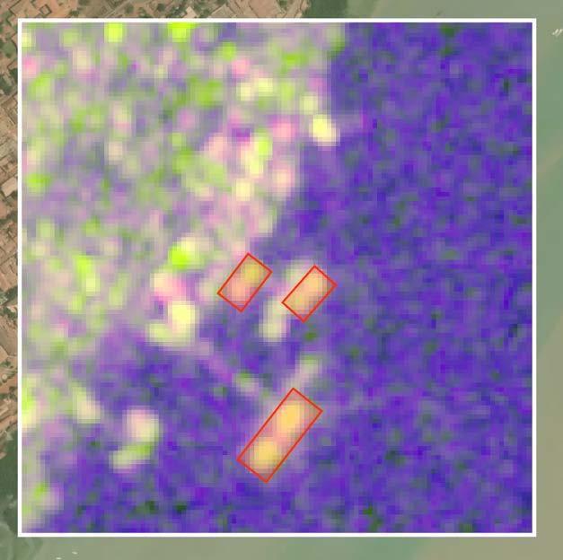
Figure 1: Detected Vessel Locations at the Port of Bissau (SpaceKnow, Sentinel-1, 21 August 2023)
- Consistent variation in container occupancy at the port, with time-series data capturing periods of high storage density
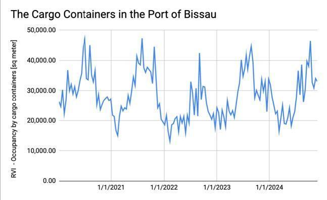
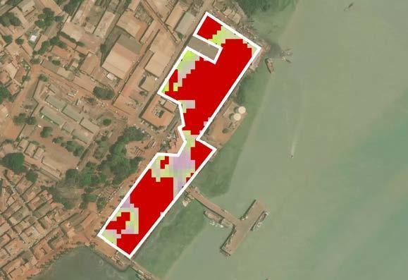
Figure 2: Time-Series of Detected Container Locations at the Port of Bissau (Radar Image: Spaceknow, Sentinel-1, 26 November 2024)
- Transport routes showing varying activity levels, suggesting possible seasonal or event-based shifts
The same workflow can be adapted to support similar World Bank infrastructure projects in other regions.
DLR contributed updated datasets on settlement patterns and population distribution to help target areas with growing demand for transport infrastructure.
Meanwhile, IABG applied regional flood hazard and flash flood modelling to identify sections of the road network highly exposed to seasonal or extreme flood events.

Figure 3: National flood hazard map with road network classified by exposure to floods. Background: OpenStreetMap (OSM) Basemap.

Figure 4: Flash flood hazard model for 100-year return period. Background: OpenStreetMap (OSM) Basemap.
This EO activity aligns closely with the World Bank’s infrastructure strategy in Guinea-Bissau. The analysis supports two ongoing road projects and informs the country’s nascent national transport and logistics strategy.
Paving the way for sustainable infrastructure investment
The EO-derived products are expected to inform strategic discussions under the World Bank’s Enhancing Connectivity in Northern Guinea-Bissau Project, and could support future technical assistance or investment planning The World Bank team indicated that the Client State is interested in using satellite data to assess road accessibility throughout the year, detect areas prone to water stagnation, and monitor long-term degradation trends—key inputs for climate-resilient infrastructure planning.
While traffic tracking remains limited due to resolution constraints, the initial insights on port activity, vehicle congestion, and flood vulnerability have already proved useful. There is also interest in using these results to train national actors in EO interpretation and decision-making, though institutional capacity remains limited.
Looking ahead, SpaceKnow is exploring the use of Sentinel-2 optical imagery alongside their analytics to monitor land development and infrastructure construction. This includes assessing the impact of transport investments on forested and non-urban areas. These potential developments remain exploratory and will depend on feedback from the World Bank team on the utility of the first data delivery.
This activity is still ongoing, and while initial EO results have been delivered, there are no confirmed updates yet on their uptake by the World Bank team. Uptake will be revisited and reported once the engagement progresses further.
Guinea-Bissau may be small, but the challenges it faces (limited connectivity, climate vulnerability, and constrained planning capacity) are emblematic of broader issues in fragile contexts. The ESA GDA T&I consortium is helping the World Bank and government partners better understand what infrastructure exists, where it’s vulnerable, and how EO can improve decision-making.