In regions heavily reliant on smallholder farming, access to timely climate information is essential for building resilient agricultural systems. Ghana, like many other countries, faces mounting challenges in food production due to increasing weather variability linked to climate change. Yet, much of the country still lacks a reliable agricultural land baseline and accessible, decision-ready climate data.
As part of ESA’s Global Development Assistance (GDA) programme, the Agriculture thematic activity is supporting the World Bank’s Food System Resilience Programme (FSRP) by delivering Earth Observation (EO)-based tools and data services aligned with the programme’s objectives. This use case demonstrates how EO can be embedded within IFI-supported national strategies, contributing to both immediate planning needs and long-term institutional integration.
EO and field data to support food system resilience
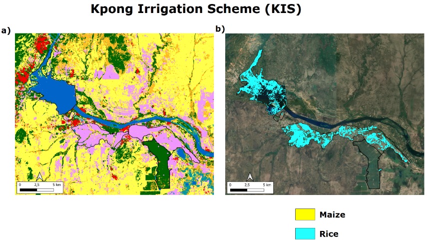
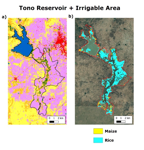
Annual crops such as maize and rice are central to Ghana’s domestic food supply, particularly in the regions covered by the FSRP. However, the lack of in-situ crop data and an incomplete overview of national land use have long posed challenges to evidence-based policy design.
To address this gap, a field survey was conducted by the FSRP in August–September 2023 across southern, central, and northern Ghana. Nearly 800 crop data points were collected and used by VITO to develop EO-based crop classifiers. These algorithms successfully mapped high-priority production zones, including large-scale rice cultivation areas around the Tono reservoir and the Kpong Irrigation Scheme.
To ensure continuity, VITO, under ESA’s GDA programme and with support from the World Bank, delivered a capacity-building training in Accra in March 2024. Officials from Ghana’s Ministry of Food and Agriculture were trained to use the Crop Observe mobile app for in-situ crop observations—empowering national actors to scale up data collection independently in future seasons.
Climate modelling tools to inform adaptation strategies
Despite the availability of various global climate tools, Ghana previously lacked an integrated digital advisory service that combines EO data with historical and projected climate impacts, seasonal forecasts, and crop suitability analysis.
To fill this gap, VITO adapted its CLIMTAG platform (Climate Information Tool for Agriculture)—already in use in 23 African countries—into a Ghana-specific dashboard. Co-designed through stakeholder consultations led by the African Centre of Meteorological Applications for Development (ACMAD), the platform includes inputs from ministries, researchers, meteorological services, and NGOs.
The Ghana CLIMTAG dashboard provides district-level access to agro-climatic indicators for historical, current, and future periods (1981–2100), under RCP 2.6, 4.5, and 8.5 climate scenarios. It integrates EO-derived land cover maps, soil moisture, evapotranspiration, and precipitation data with climate projections and crop suitability indices for maize, soybeans, groundnuts, and tobacco.
The suitability index illustrates how optimal growing conditions shift over time under climate change. For example, under RCP 8.5, an increasing precipitation deficit is projected during the early rainy season, with direct implications for planting schedules and irrigation planning.


Operational use for seasonal forecasting and planning
In the short term, seasonal forecasts help farmers make informed decisions by anticipating droughts or excessive rainfall. The Ghana CLIMTAG dashboard includes ten-daily forecasts and three- to six-month precipitation outlooks, enabling users to adjust field operations in near-real time. A recent forecast for April–June 2024 showed varying expectations across four sample districts—from very likely wetter-than-usual conditions in the South to likely drier conditions in the North.
These EO-enabled insights directly support the digital advisory services component of the World Bank’s FSRP, reinforcing its mission to build more resilient food systems through data-driven planning and timely interventions.
Advancing IFI uptake of EO for agricultural resilience

This use case exemplifies how ESA’s GDA programme is facilitating the mainstreaming of EO within International Financial Institutions (IFIs) such as the World Bank. Through technical services, tool co-development, and targeted capacity-building, ESA’s GDA helps IFIs design, implement, and scale EO-based solutions that meet both institutional goals and local development needs.
Positive feedback from Ghanaian stakeholders highlights the operational value of the dashboard. By integrating climate data, EO products, and field-collected inputs into a unified interface, national institutions—including the Ministry of Food and Agriculture, the Ghana Meteorological Agency, and FSRP teams—can now assess agricultural risks more effectively across both seasonal timescales and long-term climate scenarios.Looking ahead, Ghana plans to operationalise the new Ghana Agriculture Agribusiness Platform (GhAAP). Building on the positive reception and early institutional uptake of EO-based tools like CLIMTAG by national agencies and FSRP teams, integrating the dashboard into GhAAP could further expand access and usability. This would enable a wider range of stakeholders—especially farmers—to directly benefit from the EO insights and services developed under this ESA GDA-supported initiative.