Niger, a Sub-Saharan African country, is highly vulnerable to the impacts of climate change and extreme weather events. The country’s geography and socio-economic conditions make it susceptible to various climate-related challenges, including flooding and droughts. Severe heat waves linked to global warming exacerbate the aforementioned risks on people’s lives but also on the artificial environment, including energy supply infrastructure. Each time single factors reach higher extrema more often, subsequently the frequency of such events increases, the environmental vulnerability amplifies, and people & assets are prone to being harmed in a growing number.
This story will emphasise on sketching Earth Observation (EO) solutions linked to severe flooding, happening to Niger on a regular basis. During the last severe event in 2022, 168 people died in the city of Niamey, where the water of heavy rainfalls converted the river Niger into a destructive stream sweeping away everything in its way.
Niger – An almost empty map when it comes to documented disasters
As the political situation is in a fragile equilibrium in Niger, access to reliable and independent data is challenging. Severe flooding events are hardly documented, neither in national nor global data sets, whereas the hazard is known.
Projects granting loans for the planning, construction, and maintenance of infrastructure aim to gear sustainable engineering. This includes smart decisions on suitable locations, technical alignment, and dimensioning in order to withstand the intensity and frequency of such hazards. An objective understanding of the region is important to plan sustainable and targeted investments to upgrade existing or construct new energy network infrastructure. Whereas in humid regions open information layers provide valuable input for first vulnerability categorisation, within the Sahel Zone performing flash flood modelling is the sufficient choice.
The energy transmission grid is mainly located in the south of Niger, where the environmental circumstances allow a living for most of the country’s population. Living often depends on pasture farming and agriculture, and people live in rather small cities. The capital Niamey located at the river Niger being an exception with almost 1 million inhabitants. Here, population and state projects are competing for less exposed terrain.
Two different thematics need to be addressed:
- Planning and construction of critical infrastructure in less exposed terrain and/ or dimensioning the latter to withstand hazardous events, and
- Better understanding the exposure of current distribution infrastructure, specifically in the city of Niamey
EO solutions leading the way
The GDA Clean Energy thematic activity and national representatives of World Bank (WB) did emphasise on elaborating preliminary needs which were linked in understanding the water volume and discharge in case of severe rainfall considering the exposure of present and planned assets. Archives, containing open and national data, turn out to not reflect the flood events sufficiently.
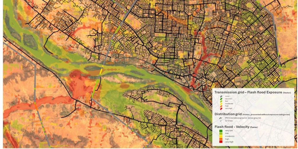
Flash flood modelling of regional scale was generated for the Western Grid, considering environmental aspects beyond terrain, all influencing water absorption capacity and drainage, a hundred-year event was simulated (HQ100) and linked to the transmission and distribution assets.
The analysis allows the WB team for the first time to estimate the vulnerability of energy assets based on exposure classes. An increased knowledge of potential impacts of severe events builds the baseline for damage and impact estimation.
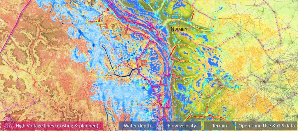
Knowledge of flood exposure in combination with environmental indicators, e. g. multi-annual vegetation behaviour, heat maps or average annual solar radiation, allows to tailor the design and network optimization down to reinforcing single assets.
The classification of power towers, of transmission and distribution line segments with known construction details like age and material, allow a sustainable and thus prudent financial management of infrastructure. It further supports the targeted expansion of transmission lines and energy grids.
Understanding hazards and extrema – the key for strategic & efficient asset management
With this ESA GDA Use Case development, the WB team has a tool at hand, allowing to dimension and adjust actions & financial loans related to individual project regions.
The tool contributes to the Electricity Access Expansion Project (NElAcEP) to increase access to electricity in the country and the Niger Accelerating Electricity Access Project (Haské) focusing on expansion of transmission infrastructure.
By linking exposure categories to existing single assets or planned corridors, individual sets of assets can be selected, and the assigned information serves the needs of multiple user groups. The thematic focus of these user groups varies in its content and depth. Therefore,different questions need to be raised and answered when it comes to planning, technical implementation or maintenance work. The sensibility of topics can hereby range from e.g. stability of the surface, exposure to flood, effects due to human expansion, triggering factors.
For Niger, the implementation of most recent EO solutions derived within GDA Clean Energy into WB projects is new and complements the effort already taken on ground. Combining open layers and the modelling based on the latter creates a generic geospatial picture that did not exist before. It makes the services attractive to the WB teams, adds value to their in-house available data and thus increases its usability. The WB team expressed its interest in enriching their decisions when supporting national programs to local development, allowing to tailor loan related investments.


