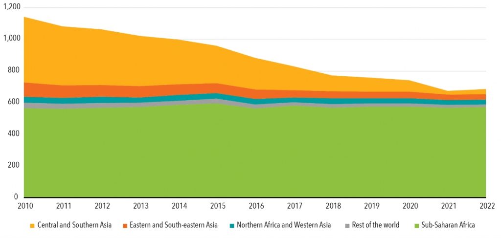
Energy access is a fundamental driver of sustainable development, enabling economic growth, healthcare improvements, and education. Without reliable energy, progress stalls, leaving many development goals unattainable. This is starkly illustrated by Sustainable Development Goal 7 (SDG-7), which aims to provide affordable, reliable, and sustainable energy for all by 2030. Yet despite global efforts, an estimated 685 million people still lacked access to electricity in 2022, with 80% of this population residing in Sub-Saharan Africa. In rural areas, the challenge is even greater as access to electricity has declined over the past decade.

Achieving universal energy access in remote regions requires a shift toward decentralised, renewable-powered solutions such as mini-grids and solar home systems. However, extending national grids to rural, often isolated, communities is prohibitively expensive. The first critical step in addressing this issue is identifying these communities and gaining a clear understanding of their energy needs. This is where Earth Observation (EO) technologies prove invaluable, offering a faster, more cost-effective approach to mapping underserved communities, eliminating the need for time-intensive and costly ground surveys.
Closing Data Gaps in Energy Planning with Satellite Technology
Satellites provide an unprecedented level of data on a global scale, which can be leveraged to map and analyse the needs of remote communities in real time. By utilising satellite imagery and advanced geospatial analytics, governments and organisations can quickly identify underserved populations, map their locations, and assess the energy solutions best suited to meet their needs. This aligns closely with the goals highlighted in the World Bank’s Global Electrification Scorecard, which measures progress and gaps in achieving universal electricity access. The Scorecard underscores the critical need for targeted interventions in underserved areas and highlights the potential of satellite technology in bridging these gaps.
Importantly, thanks to the Copernicus programme, this data is often freely available, reducing barriers to its adoption in energy planning. This approach not only supports the development of renewable energy infrastructure, such as solar, wind, and mini-grid systems, but also contributes to achieving broader energy access goals as outlined in the World Bank’s activities in the energy sector. By integrating satellite data with such global initiatives, countries can better prioritise investments, monitor progress, and ensure that no community is left behind in the transition to sustainable energy solutions.
The World Bank’s Global Electrification Platform, under its Energy Sector Management Assistance Program (ESMAP), has already demonstrated the value of satellite-derived data in identifying electrification scenarios for low-access countries. This platform combines data such as building footprints, population density, and energy consumption to create investment scenarios. However, it largely overlooks energy demands for agricultural, commercial, and industrial activities—referred to as “productive uses of energy“—which are critical in rural regions, particularly in Sub-Saharan Africa.
In these rural areas, agriculture remains the backbone of local economies, providing livelihoods and subsistence for millions. Access to electricity has the potential to significantly enhance agricultural productivity by enabling modern irrigation systems, reducing dependence on manual labor, and supporting the use of machinery for processing and storage. Moreover, electrification facilitates value-added activities such as transforming raw agricultural products into higher-value goods like milled grain or processed oils. This, in turn, helps to stabilise energy demand and ensures the long-term viability of electrification projects. To address these gaps, the ESA’s Global Development Assistance (GDA) programme is working to integrate productive uses of energy into electrification models, leveraging Earth Observation data to better assess and plan for the energy needs of agriculture and other key sectors.
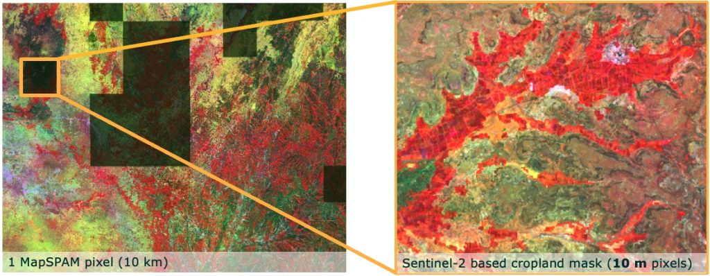
Data for mapping agricultural land and its associated energy needs has historically been limited, with existing datasets, such as MapSPAM, relying on outdated surveys and providing only broad, regional insights on a coarse spatial resolution. While global land cover maps, like ESA’s WorldCover, offer spatial resolutions as fine as 10 metres, they on the contrary fall short in differentiating complex agricultural landscapes in detail, particularly smallholder farms, where timely and detailed data is essential. ESA’s GDA programme is now closing this gap through advanced EO technologies, delivering high-resolution (spatial and thematic) cropland and irrigation maps that enable more precise assessments of energy demand for productive uses.
Madagascar: A Case Study in Satellite-Driven Electrification
Madagascar, where two-thirds of the population—around 18 million people—still lack access to electricity, has become a focal point for testing these advanced satellite-driven approaches. Working alongside the World Bank, which has pledged $400 million for its Digital and Energy Connectivity for Inclusion in Madagascar Project (DECIM), ESA’s GDA Clean Energy thematic activity has developed pilot projects using Sentinel satellite data to map cropland and irrigation systems in rural areas.
Using high-resolution Sentinel-2 satellite imagery, the GDA programme produced detailed cropland maps that identify even smallholder farms. This data is critical for understanding local energy demands tied to agricultural productivity. By integrating data from Sentinel-1 satellites, which are sensitive to soil moisture and ideal for mapping irrigation, the project has created precise irrigation maps—key to identifying areas where electricity-powered agricultural technologies could have the greatest impact.
Turning Data Into Action: ESA’s GDA Clean Energy Platform
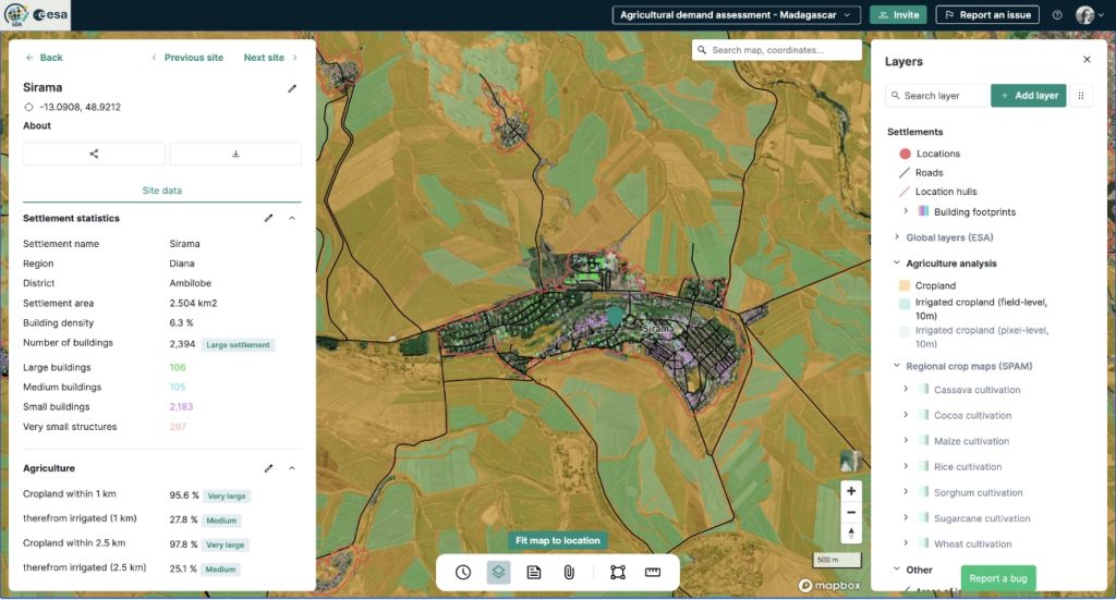
Crucially, the data generated through this initiative is not just accessible to experts. The GDA Clean Energy Platform, developed in collaboration with VIDA, offers a user-friendly interface that displays all relevant data layers, including settlement profiles, cropland distribution, and irrigation potential. Decision-makers can use the platform to filter settlements by size or agricultural activity, enabling more efficient electrification planning that takes productive energy uses into account.This data-driven approach, powered by ESA’s freely available Sentinel satellite imagery, provides a scalable model for electrification planning. With regularly updated crop maps and potential thematic extensions such as crop type analysis, this methodology offers the precision and adaptability needed to support large-scale electrification efforts in rural regions globally. The resulting maps are equally detailed and accurate, offering valuable insights into local cultivation practices, and thereby complementing global products like ESA’s World Cereal maps.
Scaling Impact Through Partnerships
The partnership between ESA’s GDA programme and the World Bank has demonstrated the potential for multilateral collaboration to address critical data gaps, equipping governments and development organisations with innovative tools to advance sustainable energy access. By leveraging ESA’s satellite data expertise and aligning it with the World Bank’s operational and financial frameworks, energy planning for underserved regions, such as rural areas in Madagascar, can be enhanced. This integration holds promise for supporting economic growth and agricultural productivity by considering agricultural needs from the initial stages of electrification projects.
The developed prototypes serve as a proof of concept, showcasing how geospatial analytics can complement development financing. These efforts lay a strong foundation for future integration into WB and other IFI work practices, offering a compelling vision of how data-driven solutions can catalyse transformative change and help bridge the energy access gap for the 685 million people still living without electricity.


