Story
Bangladesh is one of the most vulnerable countries related to climate change, as it is prone to experience various extreme events such as flooding, cyclones, and droughts. The Global Climate Risk Index (CRI) ranked Bangladesh seventh on the list of countries most affected by climate devastation over the last two decades (CRI, Germanwatch e.V.). This precondition is a key factor in the decision-making and design of financing projects, including those that seek to advance and support the electrification effort in the country.
World Bank (WB) dedicated over $500 million to support Bangladesh by launching the Electricity Distribution Modernization Program (EDMP). As part of the Program-for-Results Operation, this is initiated to support sustainable development and aims to improve the distribution, reliability, and efficiency of electricity supply and to strengthen the institutional capacity and readiness for its sustainable transformation (see World Bank’s press release, 2022). The represented use case example provides valuable geospatial information capable of supporting this process, by preparing information for the two implementing organisations responsible to advance this process: The Bangladesh Rural Electrification Board (BREB) and Power Cell, the technical division of the Ministry of Power, Energy and Mineral Resources (MPEMR).

The ESA GDA Clean Energy Activity aims to support in categorising climate risks for the Bangladesh power system at multiple scales and will participate in the implementation of an indicator and funding disbursement. The latter relates to Bangladesh’s development and adoption of policies to address climate risk, extreme weather, and disaster risk to the country’s electricity network. An extended use case addresses the assessment of the energy infrastructure vulnerability by estimating the relevant climate and disaster risks accordingly, applications are developed and showcased. On the side of WB, the teams establish their own platforms and standardised data pools on a global level, monitoring and reporting national specifications (see World Bank’s Climate Knowledge Portal). The services of the GDA Clean Energy Consortium happily consider these analyses whenever possible and suitable. The developments of the GDA Clean Energy Thematic Activity prepare extended solutions with regard to a larger scale considering the most recent freely available global and national data sets. It further provides answers supporting the exposure assessment of energy-related assets to the natural hazards and extreme events Bangladesh is facing. The analyses consider the information shared by the teams at WB, focus on their specific challenges, most recent developments and needs in providing national to local solutions.

Flood – the most prominent hazard
Flooding is a highly pressing issue in Bangladesh, caused by heavy rain falls and the resulting swelling rivers that flood large parts of the country during the annual monsoon season. Within the GDA Clean Energy Activity, the consortium focuses on the exposure and vulnerability of energy assets to these events to prepare the ground for a tailored monitoring on national, regional, and local level.
General analyses conducted by WB or other institutions often focus on and link to the vulnerability of the affected people, mostly related to administrative units or to a coarse homogeneous raster. Even though focusing on energy assets, this coarse regionalisation is often a first step to identify regions where energy infrastructure faces a significant threat in regard to natural disastrous events.
A general understanding and regionalisation of the country is achieved by considering global sources, describing topography, land use and land cover, and other surface elements, drawing a general picture of the environment and potentially related threats.
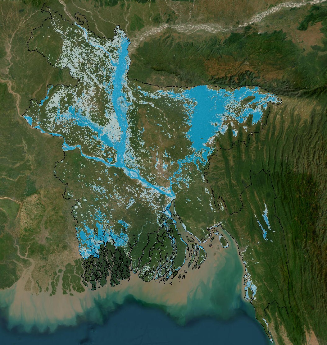
Figure 3a: Flooding events of the recent years (starting 2007)
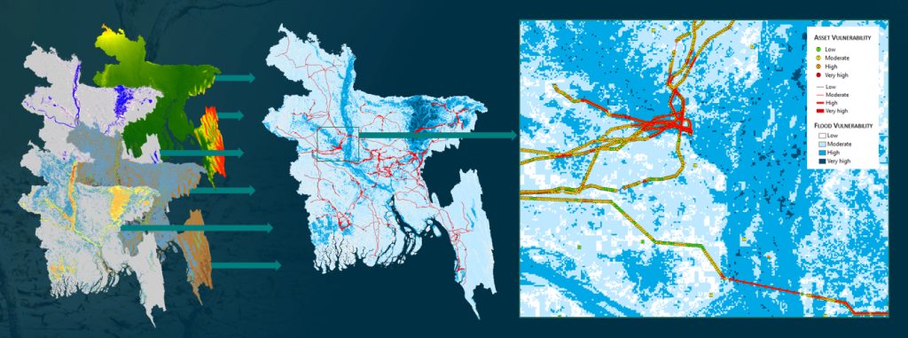
When it comes to the modelling of potential and severe flooding, the analyses benefit from globally available climate and weather data, their range, and recent extrema. The value of these sources increases every year, as shared data is now able to sketch the previous decades. Copernicus and other satellites acquire a dense net of data, suitable to provide the baseline for national and regional analysis. The latter is a prerequisite for modelling exposure of energy infrastructure to seasonal but irregular periodic events alike.
Figure 4 shows the flood exposure classification of energy distribution assets in Bangladesh on a national level. It highlights transmission line segments severely prone to flooding and allows the identification of regions where maintenance and monitoring of the assets require higher attention and targeted intervention on pylon level is highly efficient.
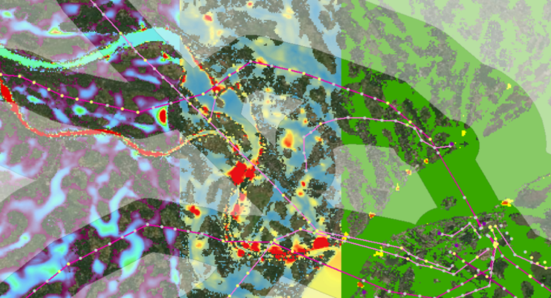
More detailed hydro-modelling is sufficient to be applied on smaller extents respectively local level, previously identified as potential hot-spots or areas of specific interest. Here, the water extent in case of a heavy rainfall event is modelled, the runoff velocities are calculated and translated into exposure classes. For both – national regionalisation and the local level – the information extracted is assigned to the energy infrastructure network and single constructions.
Inter-annual floods of considerable duration led to a softening of the soil. In combination with the flow of water, rivers create an increased risk of soil erosion. In humid countries like Bangladesh, this can lead to annual changes of river courses of up to several hundred metres (see Figure 6).
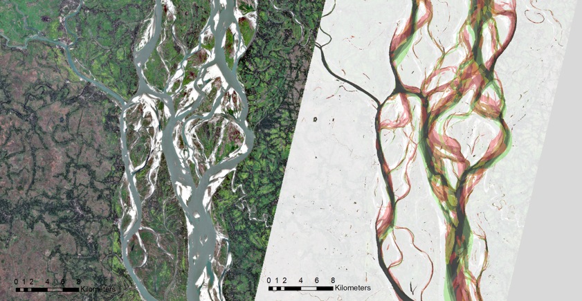
Thus, the infrastructure is exposed to changing threats: potential weakening of the assets foundations due to change in terrain, corrosion due to ranging exposure to water (height and duration of flooding), as well as damage due to floating objects.
The GDA Clean Energy consortium provides monitoring solutions for such changes within short- and long-term perspective and thus provides the ground for on-demand monitoring and asset maintenance, for quantifying construction related efforts on medium- and long-term, as well as raising awareness of recovery measures likely to happen based on knowledge on exposure on asset-level to the multiple criteria.
Landslide – challenging the South-East
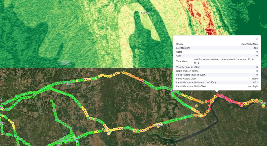
Severe rainfall events also often cause landslides, especially in the Chattogram region, at the southeast of Bangladesh. Figure 7 shows the result of the landslide susceptibility analysis performed in this region, also considering multiple parameter data sets relevant for surface stability besides the relief itself, such as geology and land cover information. The figure provides an example on the landslide susceptibility classification and the derived attributes attached to the assets of the most recent inventory.
Extreme winds – the invisible threat
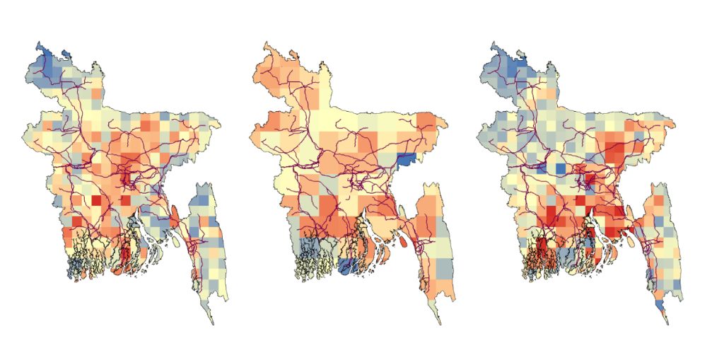
Bangladesh, being one of the highly disaster-prone countries, is not only exposed to floods and landslides but also to extreme winds. The country frequently experiences storms, from which the population and the infrastructure, including energy assets, are severely impacted. A high resolution modelled climate data for a specific return level and considering various RCP (Representative Concentration Pathways) scenarios leads to a better vision of the energy assets exposure to extreme winds. The following figure presents the wind modelling results for 50 years return level and considering three scenarios: RCP26, RCP45 and RCP85.
One map fits all – developing distinct action plans
Our collaboration with the WB team resulted in conducting a comprehensive set of hazard analyses and providing these tailored to the project needs of the International Financial Institutions (IFIs). Our geospatial analytics became a centrepiece of the national client engagement of ESMAP, being the baseline for the national workshop held in Bangladesh late summer last year discussing solutions with the national stakeholders on ministry level (BREB, MPEMR, other). The presentation of the GDA work helped demonstrate the value proposition of GIS systems and supported building the case for including GIS as an individual component in the upcoming transmission lending operation.
Opportunities are discussed to scale up this model within the energy sector, particularly for transmission and distribution system operators to other countries through ESMAP and GDA collaboration. Understanding the spatial distribution of hazards is a key factor to develop tailored and hazard-specific management plans. The jointly elaborated analyses feed into IFI strategies on providing energy access, clean energy transition, resilience and adaptation to climate change, ensuring professional and cost-efficient maintenance, considering the severity of potential threats beforehand.
The nationwide knowledge of exposed infrastructure, aggregated to one collaborative map is a new and valuable tool for decision making. Due to the geographic situation of Bangladesh, the study is foremost focusing on flooding, landslides, extreme winds and land cover/ land cover change.
Impact – generating real uptake for IFI’s core project cycles
The consortium’s solutions shown within the GDA Clean Energy Thematic Activity carry a high potential of transferability to other countries and regions with similar challenges, already proven within GDA. Depending on location, climate and landscape characteristics, the focus relates to a varying combination of natural or human-made hazards. The central strategy lies hereby in implementing standardised procedures, fitting to the regional needs as well as the requirements of the project teams at WB. In doing so, comparable solutions ready to be implemented in IFI activities and projects are created. The approach was already transferred to Niger, where flash floods and droughts were in focus. A third investigation in Uganda added earthquakes on the list, with again being landslides and flooding the two most prominent hazards.
Climate resilience analytics in energy has thus far not leveraged EO much on the IFI side. The projects for Bangladesh, Niger and Uganda have demonstrated their relevance, options for replication and their scalability. Within GDA, the adaptability and innovation in applying the framework for risk estimation and categorisation, particularly adjusting to data gaps and the lower resolution of data, were demonstrated. This approach has opened new avenues for climate resilience planning in energy infrastructure as it will be shown with the forthcoming release of the Uganda Country Climate Development Report (CCDR), where GDA analysis results are directly fed into.
Moving forward, the WB team sees the opportunity to further integrate these EO services into their core project cycles and towards introducing it into the WB’s best practices. The potential for expanding the approach to other regions and infrastructure types has started (Niger, Uganda) and is highly valuable in advancing climate risk assessment capabilities, providing a solid foundation for future projects in this domain.


