The ESA Global Development Assistance (GDA) Transport & Infrastructure (T&I) activity supports a variety of World Bank transport and disaster-risk projects in Pakistan, including the Khyber Pass Economic Corridor Project, the Khyber Pakhtunkhwa Rural Accessibility Project (KPRAP), the Integrated Flood Resilience And Adaptation Project (IFRAP), and the Sindh Flood Emergency Rehabilitation Project (SFERP). Across these initiatives, the collaboration explores how satellite Earth Observation (EO) can improve understanding of infrastructure performance, highlight vulnerable sections of the road network, and strengthen planning and maintenance decisions for safer, more resilient connectivity throughout the country.
Overcoming infrastructure vulnerabilities in a challenging environment
Pakistan’s transport network faces significant environmental pressures, particularly in regions prone to landslides, seismic activity and seasonal flooding. The Khyber Pass is a mountainous area where road stability is a constant concern, while the Indus plain and eastern parts of the corridor regularly experience major flood events. EO can help address these challenges by providing objective, scalable insights into where roads may be vulnerable, enabling better maintenance, planning and risk reduction.
During the engagement phase, the WB team emphasised the need for comprehensive geospatial analytics to support road planning in climate-affected regions and the creation of sustainable, locally operable systems for ongoing monitoring. The team specifically highlighted technologies that help monitor road conditions, analyse disaster risk, and assess environmental impacts.
CLS and TRE ALTAMIRA, leading companies of this specific case study, outlined EO-based solutions tailored to these needs, drawing on capabilities in land cover mapping, emergency response, radar-based ground motion analysis and infrastructure stability monitoring.
Determining where infrastructure is most at risk
To support the KPEC team, the consortium developed three complementary EO services. These services target two distinct geographical contexts: the steep and mountainous, landslide-prone Khyber Pass, and the more flood-exposed Indus and Kabul river plains.
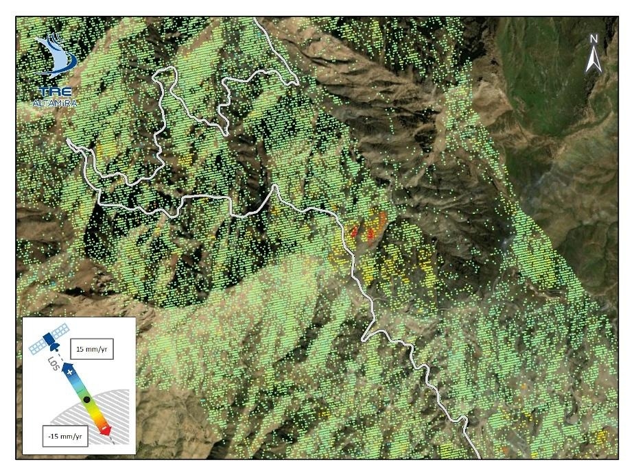
- Ground displacement monitoring (InSAR): TRE ALTAMIRA used interferometric satellite radar data from Sentinel-1 to detect very small movements of the ground along the Khyber Pass corridor and high-interest connecting roads. By analysing an image timeline over 8 years, the team identified where the ground is shifting upwards, downwards or sideways. These movements do not necessarily indicate a damaged road. Instead, it helps engineers pinpoint parts along the corridor that may be less stable and could benefit from closer and regular inspections.
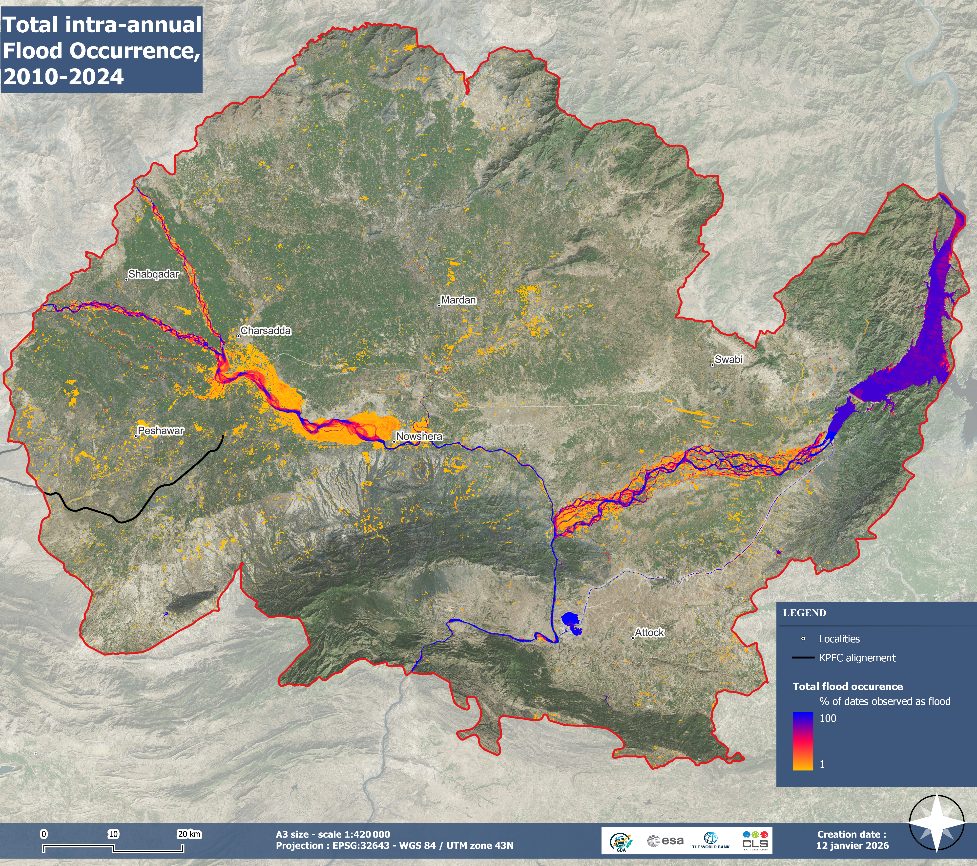
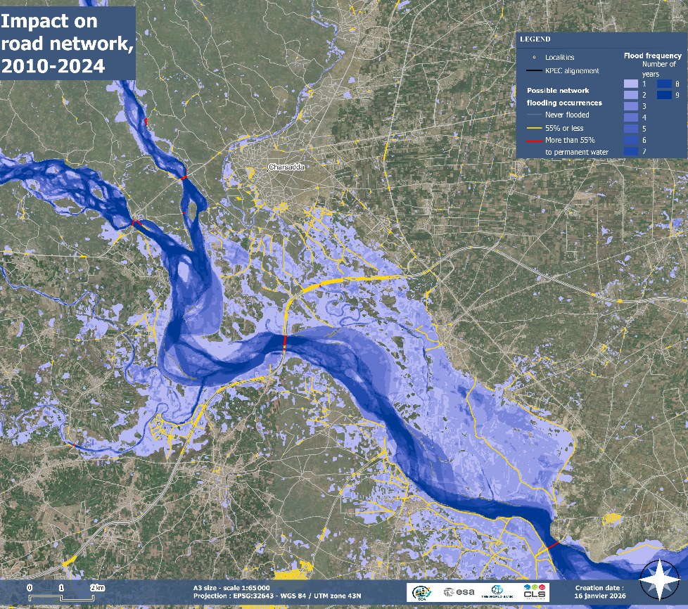
- Historical flood exposure mapping: CLS analysed radar (Sentinel-1) and optical (Sentinel-2; Landsat-5,7,8) satellite images from 2010 to 2024 to understand the frequency of flooding of different parts of the Indus and Kabul river plains. The analysis revealed where water has consistently reappeared during major and seasonal floods, as well as shifts in river channels over time. By comparing these patterns with road and bridge locations, the team identified transport assets most exposed to flooding in the past.
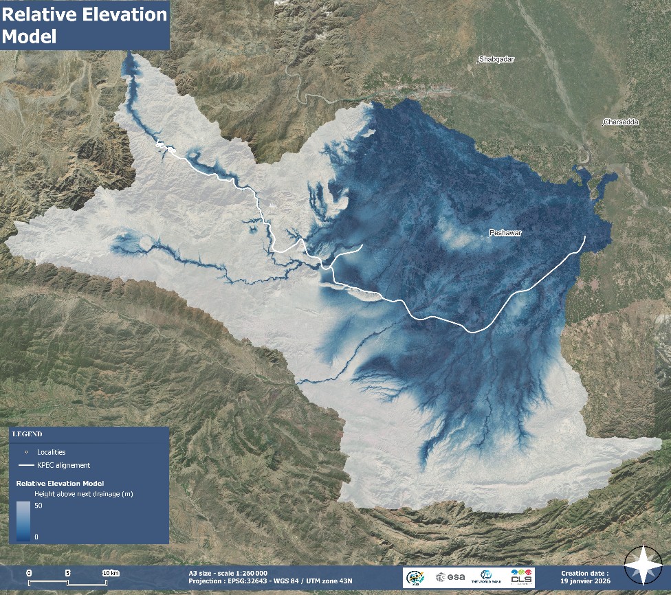
- Flash-flood susceptibility analysis: As flash floods in the Khyber Pass area are often too rapid to be captured by satellites, the team used Copernicus GLO30 elevation data to map natural pathways where water is likely to rush during heavy rainfall. By comparing these terrain-based flood-prone areas with the expressway and southern link, they identified sections of the road that could quickly be affected by sudden runoff. This offers an early indication of where protective measures may be needed, and where the road design should be adapted to withstand potential flooding.
This EO-based approach enables targeted investments that reduce repair costs, avoid flood-related damage, and strengthen the safety and resilience of Pakistan’s road network.
Leveraging EO data for evidence-based and climate-resilient planning in Pakistan
Through this collaboration, EO tools are being used to create a clearer, more granular understanding of transport vulnerability in one of Pakistan’s most strategically important corridors. The combined use of radar interferometry, flood-extent mapping, and elevation-based flash-flood analysis provides a multi-layered risk assessment that would be difficult and costly to achieve through field surveys alone.
These insights can support:
- Safer, more resilient road engineering
- Improved prioritisation of maintenance
- Climate-informed design for new road segments
- More robust investment decisions
The activity is ongoing, and as the GDA T&I work continues, the services will be refined based on user feedback and extended to new areas as required.
By integrating EO into the KPEC project, Pakistan and the World Bank can better anticipate risks along this key economic corridor, strengthening connectivity, protecting infrastructure investments and supporting long-term development across the region.
Beyond Pakistan, this approach can be replicated across other climate-vulnerable transport corridors, supporting more resilient infrastructure planning in flood-prone regions worldwide.