The European Space Agency’s GDA AID Urban Sustainability has been supporting the World Bank (WB) Second Rwanda Urban Development Project (RUDPII). The consortium is using Earth Observation (EO) to develop an Urban Wetland and Restoration Monitoring System that provides national and city authorities with visualisation tools that facilitate evidence-based urban planning.
Weathering the Storm: Empowering City Authorities to Tackle Flood Events
Kigali periodically experiences significant property destruction, displacement and loss of life due to flash flood events. In late December 2019, for example, flash floods killed at least four people and destroyed dozens of homes. Recognising the importance of wetlands in mitigating flood events such as these as well as pollution, the Government of Rwanda has been gradually restoring these crucial ecosystems for years.
Most recently, the World Bank’s Second Rwanda Urban Development Project (RUDPII) is seeking to advance these initiatives by improving access to basic services, enhance resilience and strengthen urban planning and management in Kigali and six secondary cities of Rwanda. GDA Urban Sustainability is supporting one of the project’s components piloting an integrated approach to sustainable wetland management and developing tools for evidence-based, integrated urban planning while providing institutional capacity development and support to national line agencies and the City of Kigali authority (CoK).
GDA Urban Sustainability is working alongside World Bank staff and their counterparts in Rwanda, namely the Rwanda Environmental Management Authority (REMA), the Rwanda Water Board and the CoK. The aim of GDA Urban’s involvement is to provide tools that can give authorities a clearer view of the presence of water at certain locations as well as changes to the wetland habitats in the city over a given period of time. These tools would not only improve hazard preparedness but also help authorities to gauge the success of wetland restoration efforts objectively. Using EO information, agencies will be able to better understand any potential implications for development control, agriculture, water resources and biodiversity.
Monitoring changes to urban wetland areas
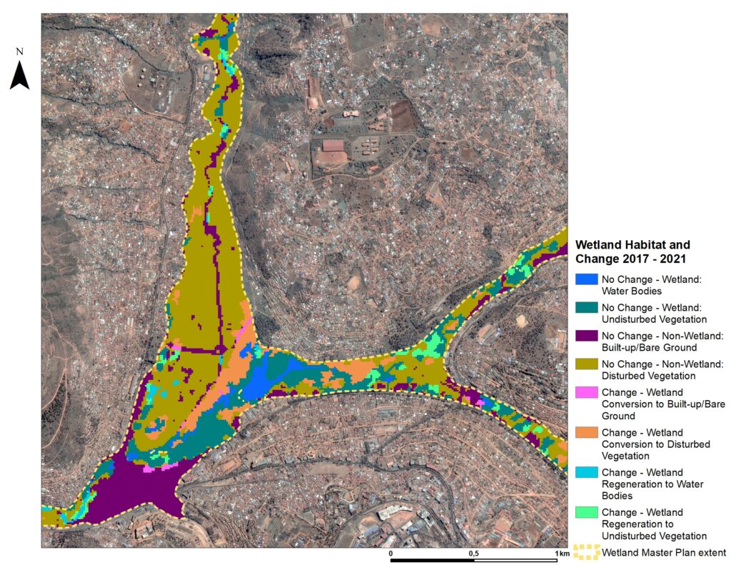
The Urban Wetland and Restoration Monitoring System consists of two baseline EO products 1) wetland habitat extent and change, and 2) water extent and frequency. Based on a deep learning model, the first allows agencies to monitor the extent and class of ‘natural’ vs human-impacted land cover types over a multi-year period. Using the Kigali Wetlands Master Plan as a key reference point, the product classifies parts of the urban wetlands based on whether any changes have been detected and whether those changes relate to ‘wetland regeneration’ or ‘wetland conversion’ to a human-impacted land cover type.
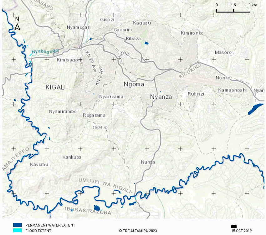
The second input product looks at the frequency and extent of surface water. Here, each pixel of a series of images is classified as either ‘water’ or ‘no water’. Viewed either as individual snapshots or across a timeseries, this can provide insights on permanent water extent, flood extent, maximum flood areas and water frequency.
GDA Urban is outlining a roadmap to support local stakeholders to consider how these baseline products could be integrated into a system which would offer regular status updates and functionalities not currently available on the open market. This would give cities an opportunity to monitor and assess the qualitative and quantitative changes of wetland areas in urban and peri-urban areas over time in a semi-automated way. Cities would therefore be able to assess if resources for wetland restoration and conservation activities are efficiently spent and whether any progress can be seen. An additional benefit of these tools is that they rely on free and open High Resolution imagery from the Copernicus Sentinel missions, which allows for regular updates of the datasets for longer-term monitoring free from high imagery acquisition costs and/or licensing restrictions.
The vital role of wetlands: shielding cities from flood risks
Urban wetland areas, such as those in Kigali, can mitigate the effects of flooding by absorbing storm water and reducing the likelihood and severity of flooding events. As Kigali, like many cities on the African continent, sees increasing trends of urbanisation, it is critical to understand what the effects of that trend could be on disaster events such as floods as urban wetland areas are lost and replaced by built-up areas, infrastructure and agriculture. Monitoring changes in urban wetland areas can help authorities to protect these areas and to take corrective action when needed.
As Rwanda seeks to integrate the use of geospatial data into more areas of its policy making by establishing a central Geospatial Data Hub, the roll-out of these tools at a national level could support even more cities to understand changes to land use and their possible impacts on flood events and other hazards. Local stakeholders, the GDA Urban consortium, and the World Bank are exploring whether the system could be delivered as part of such a national geospatial initiative and extended to new areas of interest.