In an age dominated by data, the fusion of big data technologies and Earth observation (EO) products has ushered in a new era of insights and understanding. One innovative example of this synergy is the integration of diverse datasets into a CGI big data analytics solution called Insula (previously named EOPaaS). In a prototype initiative, this integrated platform has been offered to the Asian Development Bank (ADB) to identify patterns of people movements in Afghanistan along the boundaries between Afghanistan and Tajikistan following the power takeover by the Taliban in August 2021. This activity was carried out as part of the ESA GDA Fragility, Conflict, and Security (FCS) thematic activity, which aims to address and overcome major hurdles in combating extreme poverty in low- and middle-income nations.
Understanding and responding to critical events
Let’s explore how the integration of data sources is contributing to a more informed and proactive approach to understanding and responding to critical events:
German Aerospace Centre (DLR): DLR’s settlement extent data serves as a foundational layer offering insights into the geographical spread of human settlements. This information acts as a crucial reference point for understanding population distribution, urbanisation trends, and potential areas of interest along the Tajikistan-Afghanistan border.
e-geos: High-resolution monitoring services at key checkpoints, offer observations of changes on the ground. These services, capable of capturing Very High-Resolution (VHR) imagery, offer a dynamic perspective on the evolving landscape. By integrating this data, Insula enhances its ability to detect and analyse changes such as population movement, infrastructure developments, and potential anomalies.
Janes: A renowned source for military and security open-source intelligence (OSINT), Janes contributes data specifically focused on monitoring conflicts, terrorism, and insurgency events. This valuable information enriches the analytical depth of Insula, providing insights into security dynamics and local insurgency developments that can impact population movement in the region.
HENSOLDT Analytics: Brings a unique dimension to the integrated dataset by providing OSINT and social media Open-Source Intelligence (SOSINT) data. This includes the identification of geolocated tweets and media posts mentioning locations associated with conflict, food security, disasters, and government activities.


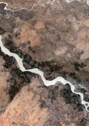
Afghanistan parking area under analysis in the vehicles / containers count

Real-time understanding of a crisis
Insula acts as the central nervous system, integrating several datasets at a time into a cohesive and actionable framework during crisis situations. It employs innovative technologies, including scalable processing, data harmonisation, and advanced analytics. This integration can transform raw data into a comprehensive, real-time understanding of the situation of people movement in Afghanistan close to the Tajikistan-Afghanistan border.
The ADB stakeholders and consortium have adopted an agile approach to access these assets. In this process, ADB, serving as the product owner, has continuously refined the outputs at each iteration by requesting additional features, new datasets, and enhanced functionalities. For example, after analysing OSINT data, an agile sprint was dedicated to monitor activities in a frequently mentioned crossing point with very high-resolution EO data. This integrated platform, using the power of big data technologies, can be replicated and used in humanitarian emergency crises due to conflict or natural hazards to support focused interventions.
The proactive approach allowed informed decision-making, enabling ADB to respond swiftly to emerging needs and focus resources to support its developing member countries accordingly. This use case has effectively demonstrated the comprehensive potential of a multidimensional approach in gathering contextual information, assessing risks, and accessing remote or conflict-affected areas.
Impact and looking forward
The integration of EO products and diverse data sources into Insula marks a significant step in leveraging big data to ultimately benefit citizens. As we witness the convergence of technology and data-driven insights, it becomes increasingly clear that such initiatives hold the key to a more resilient and responsive world, where timely actions are guided by a deeper understanding of complex situations.
The prototype initiative to monitor the Tajikistan-Afghanistan border illustrates the critical role that the use of geospatial information and data analytics plays in assessing global, regional or national challenges and supporting decision-making for better and more targeted use of resources. The project outputs were incredibly useful for ADB in supporting its clients in defining adapted policies and better-scope project outcomes. . Indeed, the data played a key role in informing and updating the situational awareness of the area and adapting the project’s intended purpose. This innovative approach and the use of the platform have demonstrated how strategically deployed multidimensional data can guide policy decisions and increase projects’ effectiveness and development impact also in politically and socially complex scenarios.