The European Space Agency (ESA) Global Development Assistance (GDA) Agile Earth Observation (EO) Information Development (AID) Climate Resilience Consortium collaborated with the Asian Development Bank’s (ADB) Fragile and Conflict-Affected Situations (FCAS) team to develop geospatial products and a new platform for assessing flood and drought risks in Afghanistan at the local, regional, and national levels.
ADB’s FCAS team supports fragile and conflict-affected areas to enhance resilience and promote sustainable development in vulnerable environments. This activity contributes to the team’s project, ‘Enhancing Differentiated Approaches for Fragile and Conflict-Affected Situations in ADB Operations,’ and allows the FCAS team and other authorized users to access all generated data to check the status of local infrastructure, assess flood and drought risks, and optimize on-site interventions.
In Afghanistan, flooding in spring and summer causes severe hardship as its population is concentrated along its main rivers. In 2022, around 110,000 people were impacted by flooding, with the most affected areas concentrated in the eastern part of the country.
In addition to flooding, Afghanistan also faces water scarcity. The country remains in the grip of one of the worst droughts and food shortage crisis in decades, which has the potential to lead to a humanitarian catastrophe, as food reserves will not be replenished before the cold winter months.
Using Earth observation data to assess such risks is particularly important for the FCAS team, as accessing remote and occasionally dangerous areas of the country is often hindered by physical, political and security constraints.
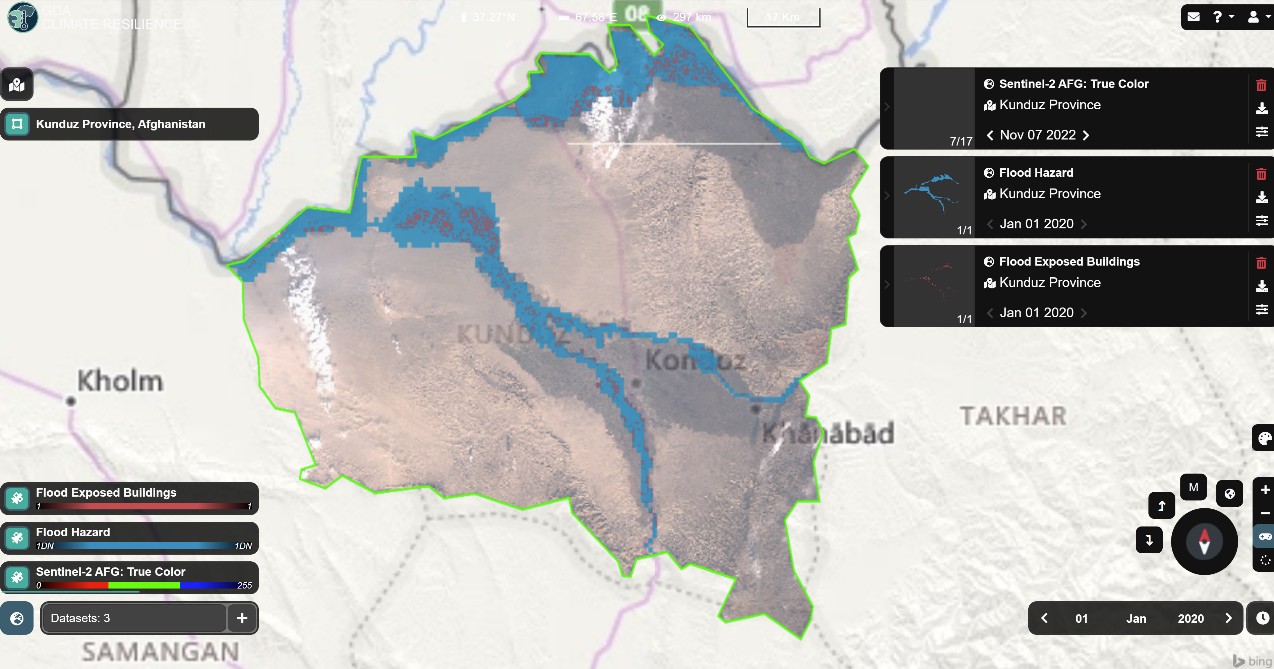
Image: A snapshot of the platform providing data for the Kunduz area. The Sentinel-2 image of Nov. 7, 2022, is provided as a background layer. The Flood hazard layer and the flood exposed buildings (50-year return level) are provided as blue and red coloured layers respectively.
The platform provides the FCAS team with the ability to access recent satellite imagery and analyse potential flood or drought risks in specific areas or regions. By integrating satellite-based datasets on precipitation, soil moisture, flood risk maps, and drought indicators, the platform offers decision-makers easy access to historical and future-oriented intelligence on flood and drought risks.
The availability of flood and drought risk information enables early warnings and preparedness, guides decisions related to agriculture and crop management, supports water resource management, facilitates insurance and financial assistance, and aids in infrastructure planning and development.
Using this platform, ADB’s FCAS team can continue to play a crucial role in supporting evidence-based decision-making and promoting effective measures to address the complex challenges posed by hydrological extremes in Afghanistan.
Learn more about how ESA’s earth observation data has been used to create tools for climate risk decision-making here.
Key Takeaways
- A new platform uses satellite imagery and climate datasets to assess flood and drought risk in Afghanistan. Floods and drought affect crop productivity and have severe impacts on food security and livelihoods.
- Satellite data provide valuable information for users in situations where it is unsafe to go into the field due to physical, political and security limitations.
- Flood and drought risk intelligence ensures the effective implementation of climate resilience and adaptation strategies, mitigating the impact of extreme weather events and promoting sustainable development in vulnerable regions.
- Satellite-based methods enable client countries to report to land-use climate funds more promptly and ultimately enable local communities to receive payments quicker.
ESA’s GDA Programme is a global partnership implemented with key International Financial Institutions (IFIs) – World Bank and Asian Development Bank – to mainstream the use of Earth Observation (EO) into development operations. For more information, please visit our website: https://gda.esa.int