Following the devastating floods which occurred in Pakistan starting from June 2022, several European specialised Earth Observation providers took part in disaster assessment efforts to assist the Asian Development Bank (ADB) with the support of ESA. Earth Observation (EO) can indeed provide key information in the event of natural disasters such as floods. While ESA and the European EO sector bring their expertise to develop such EO products, teaming up with ADB allows to leverage and mainstream the use of EO in Pakistan.
An extreme weather event influenced by Climate Change
Every year, Pakistan experiences monsoon, a tropical and subtropical seasonal phenomenon often characterised by heavy rainfalls. However, this year, the monsoon rains led to floods recorded as the deadliest in Pakistan history.
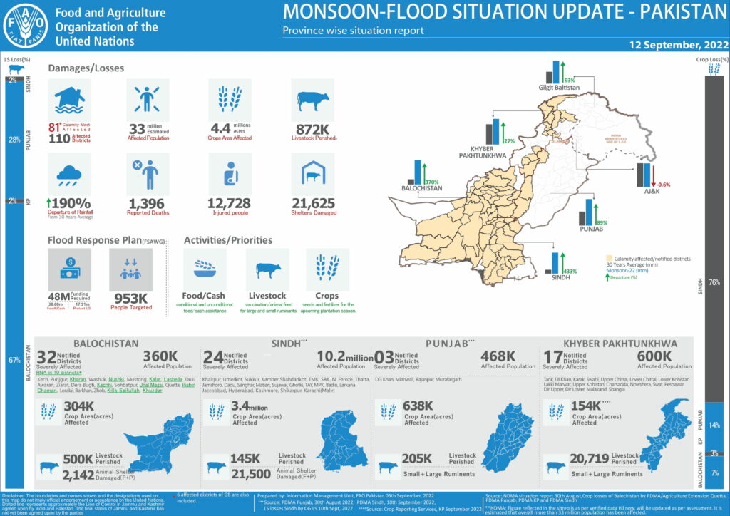
The floods started on 14 June 2022 and a state of emergency was declared on 25 August 2022 when it became clear that that the situation was more serious than the ones experienced in the past. Indeed, the precipitations were ten times heavier than usual and were following a severe heat wave which had triggered melting glaciers. The impacts are huge: About 10% of Pakistan was estimated to be flooded, more than 1,000 casualties were reported since 14 June 2022, and over 2.1 million people lost their home. The losses are estimated to reach US$40 billion with heavy damages on croplands and infrastructures.
Sherry Rehman, the Minister of climate change of Pakistan, attributed the severity of the event to climate change, calling the situation a “climate-induced humanitarian disaster of epic proportions”. Indeed, extreme weather events are likely to become more frequent and more intense with climate change.
Earth Observation: a crucial source of information for flood response
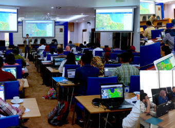
Many stakeholders including international organisations joined forces to help Pakistan respond to this crisis. The United Nations Institute for Training and Research (UNITAR), on behalf of the United Nations Office for the Coordination of Humanitarian Affairs (OCHA) submitted a request to the International Charter Space and Major Disasters for the provision of satellite based damage mapping. The activation started on 30 August 2022 and UNITAR was nominated project manager to organise the EO based response service.
Earth Observation soon appeared to be key to provide suitable and timely information which could help both rapid damage assessments and reconstructions efforts. In this context, the Asian Development Bank (ADB) commissioned CIMA Foundation who teamed up with the Luxembourg Institute of Science and Technology (LIST) to provide a detailed assessment of the hazard impact using a large collection of Sentinel data data across Pakistan.
CIMA and LIST are both members of the ESA’s Global Development Assistance (GDA) Disaster Resilience consortium, which aims at demonstrating and leveraging the use of Earth Observation in all phases of the Disaster Risk Management cycle. Since ADB is one of the main partners of the GDA programme they were able to quickly identify CIMA and LIST to provide support to the Pakistan resident mission of ADB. They delivered an in-depth hazard impact assessment based on the strong processing capacity that they acquired as a result of several years of scientific and technological investments supported by ESA through initiatives such as the FutureEO programme, the Earth Observation for Sustainable Development (EO4SD) and the on-going GDA programme which focuses on mainstreaming the use of EO within International Financial Institutions (IFIs) operations.
The monitoring service provided for Pakistan was first designed and implemented for Risk Transfer and Insurance. The same service is currently being enhanced for Disaster Risk Management as part of the GDA programme and has proven to be useful in providing stakeholders and decision-makers with valuable information:
- For disaster preparedness, as it can support the identification of Nature-Based Solutions that contribute to climate change adaption, as well as risk transfer measures,
- During the response, as the service can be used as a rapid mechanism to monitor the event,
- In post disaster contexts, as it can support the analysis of reconstruction options for affected areas.
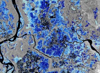
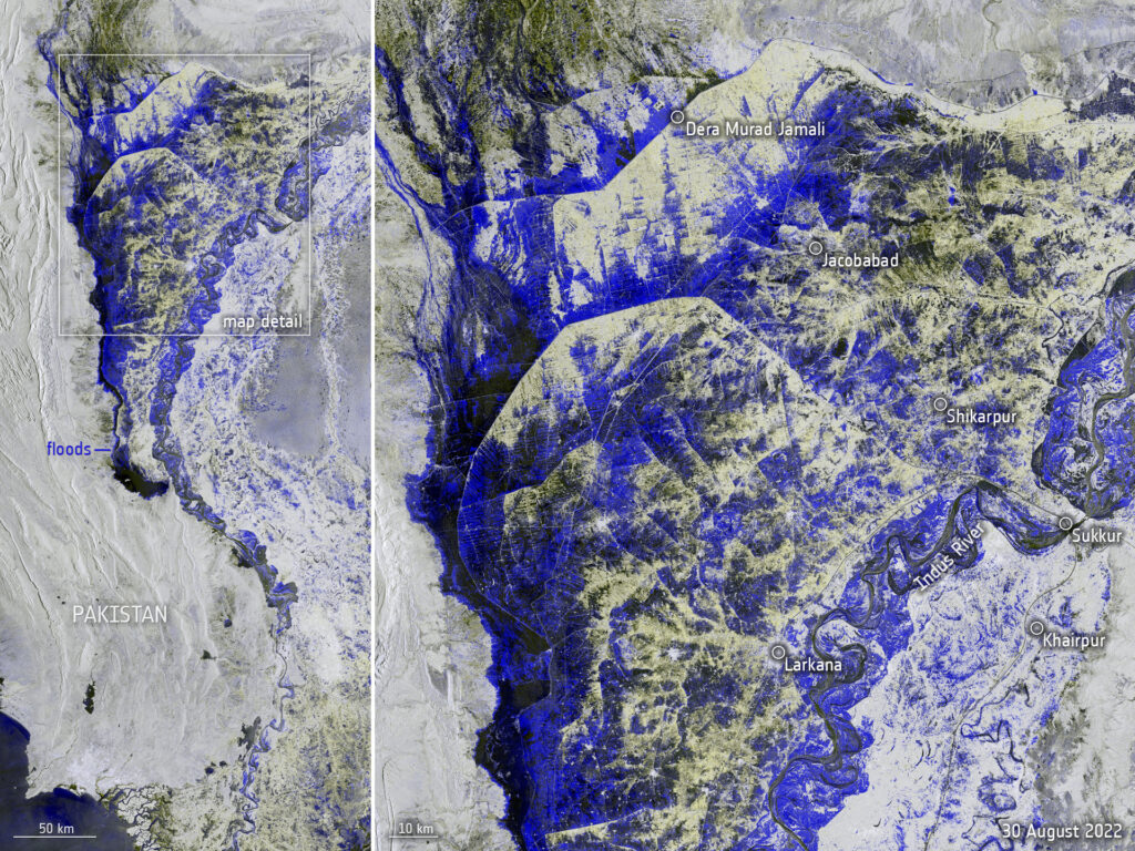
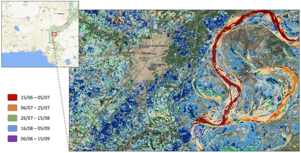
Concerning the Pakistan floods, the entire country was mapped by acquiring more than 1400 satellite images from Sentinel-1 and Sentinel-2, and by processing them using an advanced algorithm capable of detecting flooded areas using Synthetic Aperture Radar (SAR). Therefore, it was possible to identify the spatial extent of the floods and to monitor the progression of the inundations overtime. Combined with elevation information, these maps helped to estimate water depth, which is crucial for evaluating the impacts on the buildings and on the infrastructures. The products delivered include:
- The maximum spatial extent of flooded areas for the entire period,
- The flood progression overtime,
- Flood maps focusing on urban areas,
- Estimations of the maximum flood depth reached in specific areas.
The Asian Development Bank’s Pakistan resident mission reported that this type of mapping was “the most effective tool” to get valuable insight for damage assessments.
Beyond disaster response: EO for Post-Disaster Needs Assessments
Apart from contributing to the flood progression monitoring and to the preliminary damage assessments, the results were also used for Post Disaster Needs Assessment (PDNA) efforts.
PDNAs have the objective to assess the multi-sectorial damages, losses and recovery needs and to produce a comprehensive impact estimation in order to “pave the way for a consolidated recovery framework”.
In the context of the Pakistan floods, the PDNA team was given access to the products developed by CIMA Foundation and LIST through the WASDI platform, which was developed in cooperation with Fadeout software and CIMA research foundation. It enabled all stakeholders involved in the PDNA to easily access and visualise the data produced through a common on-line workspace.
Through the platform, users could access several products that help determining the multi-sector impacts of the floods in domains such as housing, transport and agriculture. Thanks to this platform, the PDNA team was able to timely identify the most severely affected villages and areas, and as a result to better plan recovery efforts.
“Flood risk authorities as well as professionals have praised the importance of using satellite imagery. These results made us realise that we need to mainstream the use of Earth Observation for future assessments including post-recovery, reconstruction and future planning.”
Asi Turangzai, on behalf of the PDNA Pakistan Team
For more information
- Sentinel Success Stories: “Space data to help Pakistan recover from its record floods”, posted on 15 November 2022
- ESA “Pakistan inundated”, posted on 1 September 2022
Acknowledgment
We would like to give special thanks to Paolo Campanella (WASDI), Marco Chini (LIST) and Ramona Pelich (LIST) for their technical contributions to this work.