The Austrian geophysical and weather service (ZAMG), member of the GDA AID Disaster Resilience consortium, has been awarded a contract with the Asian Development Bank (ADB) for the establishment of an Earth Observation-based early warning system in the Melamchi catchment (Nepal).
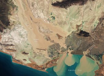
In Nepal, devastating floods in the periglacial and glacial areas of the Langtang Himal occur due to glacial lake outburst floods (GLOF), a phenomenon triggered by the sudden release of water coming from glacier melt. The risk is increased in the occurrence of meteorological events (such as heavy snow fall) as well as with seasonal snow melting, and is becoming higher with climate change. It is crucial to monitor it closely in mountain areas to ensure the safety of local population.
Thanks to Earth observation (EO), it is possible to monitor changes in periglacial areas and thus to support the early identification of GLOF risk. EO based geo-information products provide a valuable complement to in-situ monitoring stations, which are vital to generate warning information in a timely manner.
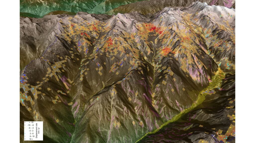
More specifically, ZAMG oversees the feasibility of an EO system for monitoring glacier lakes and snow dynamics characterising the Melamchi catchment area. Geo-information is extracted from Sentinel-1 data to assess the extent of glacier lakes and of areas covered by wet and dry snow, and for evaluating the snow melt timing. The information is available at a spatial resolution of 100 meters and is updated once or twice a week depending on the availability of Sentinel-1 data in the region. These activities are currently carried out in coordination with the ESA GDA Disaster Resilience consortium, in which Gisat also uses Sentinel-1 images to monitor terrain deformations which are taking place in slopes of the upper parts of the watershed, as well as detect changes of the hydrographic network along the river streams, and to monitor floodplains.
GEOTEST, a geo-information services provider from Switzerland was also mandated by ADB for the proof of concept of an early warning system (EWS) for the Melamchi basin. This EWS will use both in-situ sensor measurements and EO-based services based on the developments by ZAMG and the GDA AID DR consortium. Such a system is expected to help better manage risks and increase the resilience of the population as well as of the infrastructures in the upper Melamchi valley, and in a later stage, in the downstream villages.
This approach illustrates well the logic of the “Space in support of International Development Assistance” cooperation framework between ESA, the World Bank (WB) and ADB, within which ESA oversees the development of new EO products through the GDA programme, that are complemented by capacity and skills transfer activities financed by ADB and WB.