The European Space Agency (ESA) Global Development Assistance (GDA) Agile Earth Observation (EO) Information Development (AID) Climate Resilience Consortium has created a novel geospatial portal that employs earth observation data to assess climate risks in infrastructure investments. This initiative contributes to the World Bank’s Disruptive Technologies for Public Asset Governance (DT4PAG) project, which seeks to enhance the management of public infrastructure, property, and land assets through innovative digital transformations.
The DT4PAG project addresses the dual challenges of inefficiently managed public assets and rapid urbanisation in developing countries. The management processes of public assets and infrastructure are marked by inefficiency, stemming from excessive bureaucracy and paper-based systems. This becomes particularly problematic as cities undergo swift expansion, resulting in increased demand for new infrastructure.
Infrastructure and asset management processes often suffer from fragmentation, hindering collaboration within and between teams. Projects are often approved without a systematic identification and management of climate risks and opportunities. Acknowledging the need for a more integrated and systematic approach to incorporating climate considerations into investment decisions, the World Bank partnered with the GDA Climate Resilience consortium to develop a user-friendly web-interface platform.
Through this platform, Ministries of Finance and sector agencies at national and local levels can swiftly conduct, high-level climate risk assessments for potential infrastructure investment projects, such as roads, bridges, airports, and telecommunications.
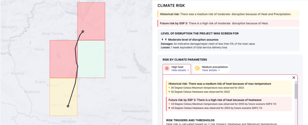
The portal enables decision-makers to gauge climate risk levels (low, medium, or high) for planned infrastructure investments, depicted through a ‘traffic light’ system of green, yellow, and red indicators. The portal’s outputs facilitate the identification of potential areas prone to climate risk exposure and pinpoint investments that may require more detailed climate risk assessments.
This portal combines climate data with satellite imagery to offer enhanced resolution of selected variables. It is pioneering in integrating downscaled global climate models with satellite data and treasury information. Future plans by the World Bank involve incorporating additional data layers into the platform, including snowfall, land-use and air-quality data.
Infrastructure must be designed, constructed and operated with consideration of the impending climate change over their lifetimes. Neglecting these risks could render infrastructure more vulnerable and prone to damage, leading to expensive repairs or even complete failure. The new portal is anticipated to enhance comprehension of climate risks and foster the development of more resilient infrastructure.
For more insights into how ESA’s earth observation data has been harnessed to create tools for climate risk decision-making, visit this link.
Key Takeaways
- A novel geospatial portal offers a high-level assessment of climate risks related to planned infrastructure investments covering essential climate variables.
- This portal is the pioneer in integrating downscaled global climate models with satellite data and treasury information.
- EO data empowers the portal to provide more precise climate risk assessments in regions with limited climate data availability.
- The portal empowers users to recognise potential climate risks to infrastructure assets, thereby facilitating discussions on risk management strategies and identifying the need for comprehensive risk assessments.
ESA’s GDA Programme is a worldwide partnership executed with key International Financial Institutions (IFIs) – World Bank and Asian Development Bank – aimed at mainstreaming the utilisation of Earth Observation (EO) in development operations. For more information, please visit our website: https://gda.esa.int