GDA AID Urban Sustainability has been supporting the World Bank (WB) “Nigeria West Africa Coastal Areas (WACA) Multi-Sector Resilience Plan” project in Warri City, Nigeria. By tapping into the expertise of the GDA AID Urban Sustainability consortium, this project has leveraged the power of satellite Earth Observation (EO) to improve risk assessment and enhance the resilience of urban areas.
Flooding dangers for coastal communities in West Africa
For years, coastal communities in West Africa have relied on the abundant natural resources of their region to sustain their livelihoods. From the fertile land to the bountiful sea, these communities have thrived on the fruits of their environment. But times are changing. With climate change causing rising sea levels and more frequent extreme weather events such as record rainfall causing flooding, these communities are facing a new reality – one that threatens their safety, well-being, and economic development.
This is a major problem, not just for the people who live in West Africa’s coastal areas, but for the entire region. After all, these coastal zones account for a huge 56% of West Africa’s gross domestic product (GDP). Without effective measures to mitigate and adapt to the effects of climate change, the hard-won development gains of the region will be severely compromised and hopes for continued growth and poverty reduction will be dashed.
In addition to flooding, these coastal areas are also facing ground deformation, which occurs when the ground sinks due to factors such as soil subsidence and erosion. This, coupled with increasing population density and rapid urbanisation, is putting even more pressure on the already vulnerable coastal zones.
How the tide is being turned
Taking action to address the pressing challenges facing West Africa’s coastal areas, the WB’s “West Africa Coastal Areas Management (WACA) Program” has been implemented in six countries, with plans for three more to join in the next phase. However, Nigeria’s unique coastal obstacles, including high levels of ground deformation and rapidly growing population density in urban areas as well as in not well consolidated terrain areas, which require a different approach, leading to the development of a Multi-Sectoral Resilience Plan (MSRP). This comprehensive plan integrates a critical asset inventory with hazard information and socio-economic measures to address the root causes of coastal degradation.
To support the MSRP work on Delta State, including Warri City and its coastal environments, GDA Urban Sustainability is providing satellite EO-based inputs, conceptual support, and visualisation tools.
Assessing risks in urban areas made easy with an interactive application
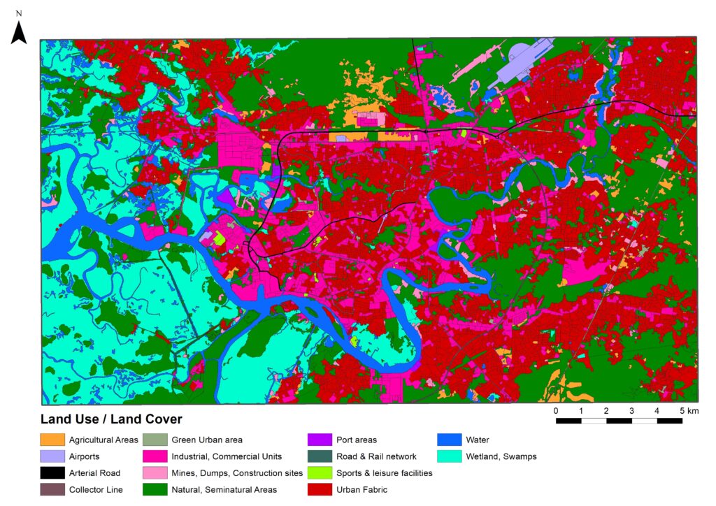
One of the components developed by the consortium is a comprehensive Land Use / Land Cover map of Warri, which provides essential information for assessing and managing risks in urban areas. This baseline information on land cover types and land uses enables decision-makers to understand what economic assets may potentially be at risk.
Moreover, the consortium is currently developing a new application that will help the local authorities to assess those risks in urban areas. The application combines a range of different types of information coming from satellite imagery and shows which areas are most likely to be affected by hazards such as flooding or ground displacement.
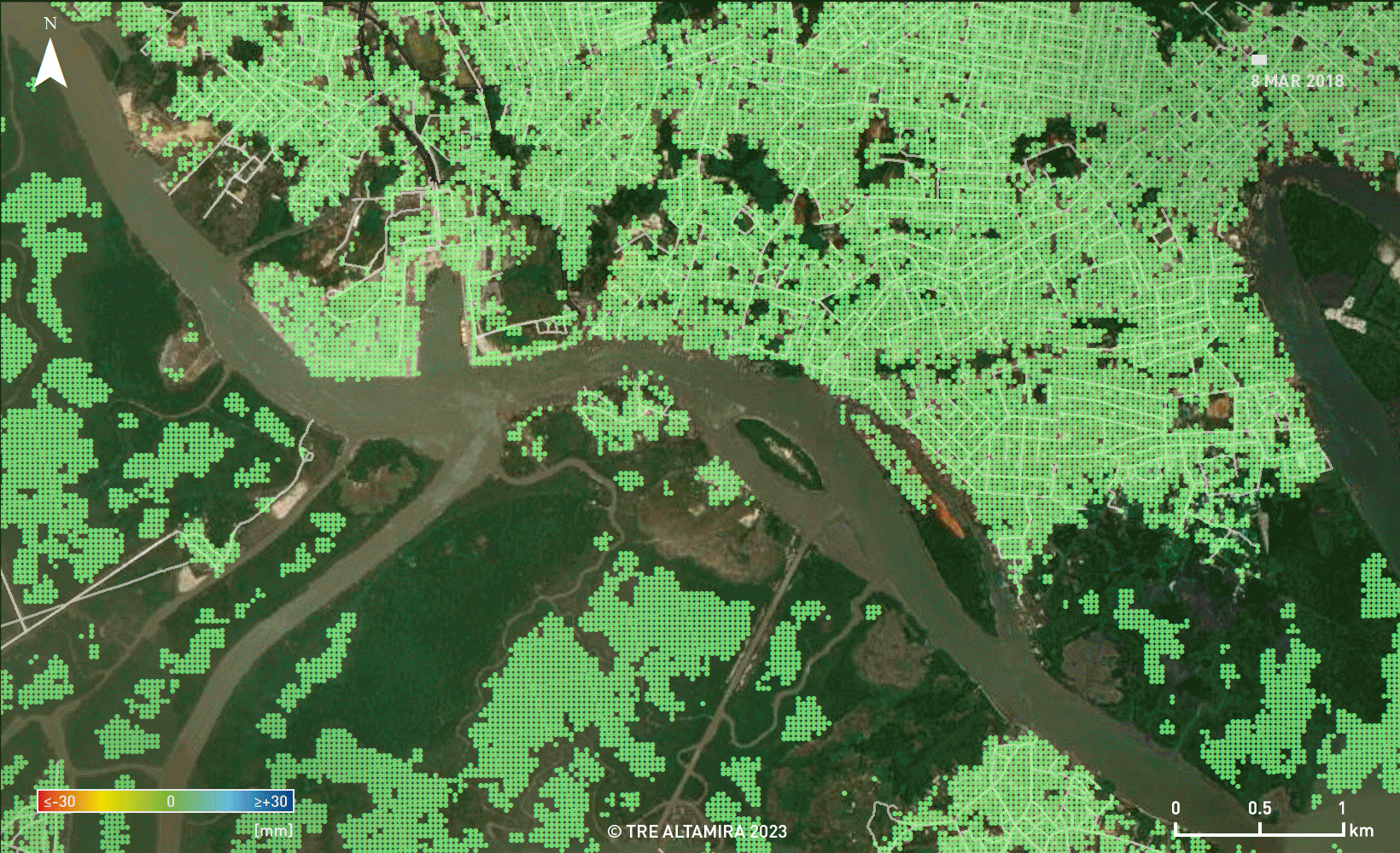
One of the key features of the application is its interactivity. Unlike other risk assessment tools that rely on fixed weightings, not allowing users to explore the data in detail, this application allows users to change the way the information is displayed and to see how this modifies the overall risk profile of different areas.
A penny spent on prevention is worth a pound spent on cure
Risk assessment is a critical component of urban planning and development, particularly in the face of increasing natural disasters and climate-related events. As such, it is essential to understand the risks that different urban assets face and take proactive steps to mitigate them.
This is where the GDA Urban Sustainability consortium’s tool comes in handy. Its benefits are particularly significant for the Nigerian authorities in Warri City, who can use the tool to make more informed decisions about where to allocate resources and how to prioritise investments to build resilience in urban areas. By providing a more detailed understanding of the risks faced by different assets, this tool has the potential to transform the way cities approach risk assessment and urban planning.
Being able to obtain the requisite data layers and integrate them in an actionable way, however, requires capacity building and some IT infrastructure to be in place. The GDA Urban consortium and the World Bank Nigeria office are currently preparing for these resources to be made available to stakeholders at the local, state and federal level by leveraging on-going and future Bank activities in the country.