Ecosystems are intricate environments that face increasing pressures, primarily driven by human interference and climate change, with their impact being the most notable factor contributing to performance degradation. The success of adaptation and restoration strategies hinges on having reliable, transparent, and consistent information about the ecosystem’s condition (ecosystem assessment). Continuous monitoring is essential to assess the impact and effectiveness of adaptation and restoration measures. Earth Observation (EO)-based services play a pivotal role by providing objective benchmarks and serving as a crucial component of environmental monitoring systems. It’s important to note that EO services offer insights over extensive geographic areas, adding unique capabilities to manual and airborne/drone-based survey methods. Furthermore, EO services enable a deeper understanding of the nature of spatial relationships between ecosystems and the human environment. This understanding is indispensable in addressing the ongoing challenges of sustainable growth.
World Bank MENA BLUE Program in Collaboration with ESA GDA Marine & Blue Economy activity: Elevating Ocean Economy Sustainability
In a strategic move to foster a more sustainable ocean economy across the Middle East and North Africa (MENA) region, the World Bank (WB) has initiated the MENA BLUE Program. The primary objective of this program is to bolster the participating countries’ capabilities in cultivating growth opportunities within the blue economy, while ensuring resilience to climate-related coastal investments, both at the national and regional levels. In a collaborative effort with the World Bank, the European Space Agency (ESA), through its GDA AID Marine Environment and Blue Economy activity, is leveraging Earth Observation (EO)-derived products furnished by an expert consortium led by Planetek Italia. The Consortium’s involvement in Tunisia is specifically geared towards supporting the assessment of marine ecosystem services, particularly in relation to the evaluation of blue carbon.
Assessment of EO-Based Services for Coastal and Marine Ecosystems: Insights and Challenges
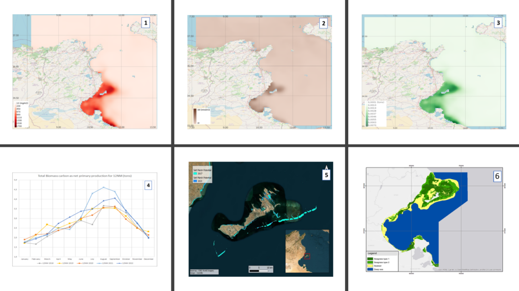
The Earth Observation (EO) services implemented in support of this WB programme pertain to three components of coastal and marine ecosystems: phytoplankton, salt marshes, and seagrass. Despite variations in constraints and accuracy, the EO services demonstrated the capacity to evaluate the extent of these components over varying timeframes and, in certain instances, the quantity of carbon sequestration. In this context, the WB-facilitated contribution of local expertise and the availability of in situ measurements are of paramount importance for validating the methodology, ensuring adaptability to changes, and reducing uncertainty in the modelling process. Based on this support, the EO data products elaborated by the ESA consortium were then integrated in a wider econometric analysis funded by the WB to assess the value of blue carbon in Tunisia.
What Impact Do These Services Have on Policy and Decision-Makers?
These services offer valuable support to policy and decision-makers in several ways:
- Providing Essential Baseline Information for Planning: National-level inventory of seagrass and salt marshes can be generated, offering baseline data for specific years (e.g., 2022). This data includes information on critical areas, proximity to anthropogenic activities, surface coverage, and, with additional in-situ or local expertise, blue carbon stock estimates. This information can inform marine spatial planning for coastal areas.
- Detecting Changes and Identifying Trends Over Time: Regular updates of ecosystem inventories, typically on an annual basis, allow the creation of change maps and updates for the data mentioned in the previous point. These change maps help in assessing trends over time.
- Evaluating Changes and Impact on Ecosystems: the capability to evaluatechanges and trends by applying Earth Observation techniques, provides key information to support the development of models to assess the impact of climate change (e.g., rising sea temperatures, sea-level rise) and economic activities (e.g., urban expansion, coastal infrastructure, pollution at sea), enabling the creation of relevant impact scenarios for marine spatial planning to protect ecosystems and their carbon stocks.
- Identifying High-Risk Areas Requiring Protection: The availability of inventories, change maps, trend assessments, and impact scenarios aids in identifying areas that are, or will likely be, more exposed to degradation risks. Specific protective measures and policies can be developed to safeguard their health and carbon stocks, or to regenerate them if degradation has already occurred.
- Enabling Ongoing Monitoring of Policy Implementation Effects: Earth Observation missions, both current and planned, provide the means to monitor ecosystems over the coming decades and assess the effects of implemented policies and regulations. This data can be used to update impact scenarios and fine-tune marine spatial planning implementation.
- Regularly Updating the Evaluation of Blue Carbon Values: In addition to the benefits mentioned above, these services enable the regular updating of blue carbon values for various ecosystems. This information is particularly relevant in terms of carbon credit assessments.
The potential applications and impacts of EO-based services for coastal ecosystems and blue carbon assessment are adaptable. They can potentially be implemented in any coastal region at the national level. However, it’s essential to emphasise that the EO-based services used must be tailored and fine-tuned for the specific coastal area(s). This fine-tuning involves incorporating local measurements, especially for blue carbon assessment, and demands close collaboration with local stakeholders such as environmental agencies, research institutes, and experts.
What is the way forward?
Since blue carbon has been historically understudied in the region, this work will help the client countries of the WB to better understand opportunities related to this sector. In Tunisia, the results and recommendations were reflected in the blue economy roadmap that was prepared by the national government with the support of World Bank. This roadmap will guide future interventions and investments in this sector for the next decade.
The World Bank is also currently expanding its analytics activities with a focus on natural ecosystems including seagrass and mangroves in the Red Sea and Gulf of Aden region. In this context, the replication and scale up of the methodology developed through this engagement is currently being assessed for Yemen and other countries of the region.
Blue carbon is a term used in the climate change mitigation context that refers to “biologically driven carbon fluxes and storage in marine systems that are amenable to management (Blue carbon – Wikipedia)