Satellite Earth Observation (EO) supports International Financial Institutions (IFIs), such as the World Bank (WB), Asian Development Bank (ADB), and African Development Bank (AfDB), with their urban sustainability programmes.
International Financial Institutions are a major source of funding for urban sustainability
International Financial Institutions contribute US$30 billion of lending directly to developing world urban projects each year. These are major investments affecting the urban experience of millions of people. These sums have steadily increased – as has the institutional and policy focus on urban sustainability from IFIs.
The WB alone has an active urban portfolio of 231 projects amounting to US$33.9 billion with four priorities:
- Enhance Planning System and Local Capacity for Cities
- Strengthen Fiscal and Financing Systems
- Promote Territorial and Spatial Development
- Build Climate Smart and Urban Resilience
An exemplar WB programme is SURGE – which supports projects in developing countries focused on green, resilient, and inclusive urban and regional development.
Equally the ADB, in Operational Priority 4: Making Cities More Liveable, of its Strategy 2030, outlines three priorities:
- Improve coverage, quality efficiency, and reliability of services in urban areas
- Strengthen urban planning and financial sustainability of cities
- Improve urban environment, climate resilience and disaster management of cities
To achieve this, ADB has outlined a total of 30 operational approaches including “build capacities and strengthen institutions” and “support infrastructure and services in urban areas”, and established or improved 210 urban infrastructure assets in 2021 alone.
Another IFI that stands out for its focus on tackling the global urban challenge is the AfDB which provides financing of over €2 billion for infrastructure projects each year. Through its new Urban Development Division, AfDB supports African cities to address environmental challenges and improve service delivery via technical assistance and policy support, as well as financing for infrastructure development. The AfDB has recently launched the Urban and Municipal Development Fund (UMDF), whose strategic priorities are:
- Sustainable urban action planning
- Project preparation and financing
- Secure private investment for urban infrastructure and develop new financial tools
As highlighted above, urban sustainability is a key priority for IFIs with hundreds of programmes and billions of dollars of development finance. What do many of these urban projects and programmes have in common? In many cases, it’s the challenge of making investment decisions and providing sound policy advice in inherently data poor environments.
This is why the European Space Agency’s (ESA) Global Development Assistance (GDA) Programme launched the Urban Sustainability (GDA Urban) activity in February 2022.
One common problem is the lack of urban data – which can be addressed by eyes in the sky
Urban planners require a variety of data to develop, enforce and improve, sustainable urban development plans. But what data are we talking about exactly?
Here’s a short sample to give you an idea: Where do people live? What socio-economic characteristics do they have? How are land uses and land cover types distributed across my planning area and how have they changed historically? Do I have an exact picture of infrastructure assets for transportation, energy, water, drainage, as well as the natural hazards they may be exposed to?
Unfortunately, often these questions cannot be easily answered in many parts of the world, particularly in developing countries where resources to regularly collect and update these datasets are scarce, relying to no small degree on time consuming and expensive in-situ surveys.
EO Information helps address these data gaps by being affordable, global, frequent, fast, continuous, impartial, and anonymous.
Interviews conducted by the consortium previously in Understanding the Impact of Earth Observation for Sustainable Urban Development, highlight a clear value for IFIs in EO addressing urban data gaps.
“Data on land use is scarce in many World Bank client countries…The EO4SD Urban products are considered as extremely helpful for any rapid urban planning/spatial planning analysis providing solution where a lack of decent city planning data or even back in time information is needed”
– Representative from World Bank Urban Spaces for City Transformation programme
“The datasets were very helpful in demonstrating urban expansion for the city in space and time at level of details and at the same time for the whole city, something what is hardly achievable in other means”
– Representative from World Bank Urban Development in Phnom Penh
GDA Urban will therefore seek to address the urban data gap by providing satellite EO Information that supports decision-making – by combining satellite EO imagery, with non-EO data, and value-adding algorithms.
Where we are now with GDA Urban
Since the project kick-off in February 2022, the GDA Urban consortium (led by GAF AG), have hosted more than 40 meetings to conduct an extensive consultation process with 17 different teams from the WB, ADB, and AfDB. This is with the aim of identifying suitable IFI projects to collaborate with.
The priority of this IFI engagement process was to ensure the EO Information produced by the consortium fit the IFI requirements, satisfied a clear demand from either the IFI and/or developing country teams, and at the same time advanced technical innovation – nothing we produce will be “off-the-shelf” or readily available on the open market today. In addition, there is a priority to have complementary activities led by the IFIs, for example capacity building, to enhance adoption of the EO Information. Consequently, eight supported IFI projects where short-listed.
| IFI Project Name | IFI | Country | City |
| Nigeria WACA Multi-Sector Resilience Plan | WB | Nigeria | Warri |
| Urban Resilience and Solid Waste Management Project | WB | Cote d’Ivoire | Abidjan |
| West Africa WAEMU Affordable Housing Finance Project | WB | Cote d’Ivoire | Multiple |
| Jordan Sustainable Cities ASA | WB | Jordan | Amman |
| Second Rwanda Urban Development Project | WB | Rwanda | Kigali |
| Kenya Integrated Urban Data Platform | AfDB | Kenya | Multiple |
| Green Transformation Action Plan / Punjab Liveable Cities Investment Project | ADB | Pakistan | Sargodha |
| Updating the Revised Strategic Transport Plan for Dhaka | ADB | Bangladesh | Dhaka |
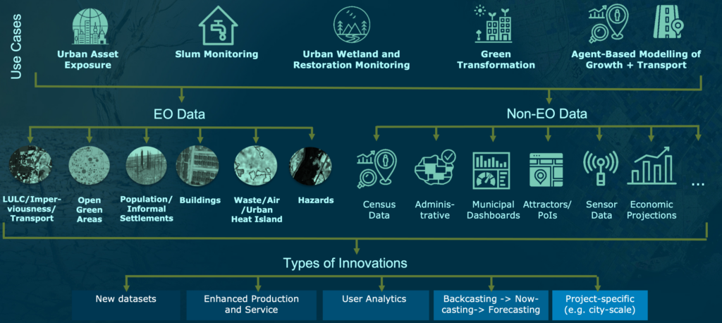
For those eight projects, the consortium is currently developing six EO Information products that will address a range of use cases including urban asset exposure, slum monitoring based on machine-learning, deep learning-based urban wetland monitoring, agent-based modelling of urban development scenarios as well as transport networks, and green transformation. All these EO Information products combine EO data from satellites with non-EO data such as from census data, administrative data, municipal dashboards, ground sensors, or economic forecasts.
GDA Urban will continue to expand support to IFIs through 2022 and into 2023
Initially, all users will be presented with “prototypes” of each of these EO Information products based on the initial user requirements gathered. Following multiple rounds of user feedback, GDA Urban will then fine-tune, expand, and innovate on these prototypes throughout the remainder of 2022 and into 2023. Following on from this blog will be a series of blogs detailing these IFI programme engagements, the urban use cases, and the specific EO Information provided.
Further information is available on the GDA Urban website and via this summary video.
Please contact the GAF AG team via gda-urban@gaf.de with any questions.