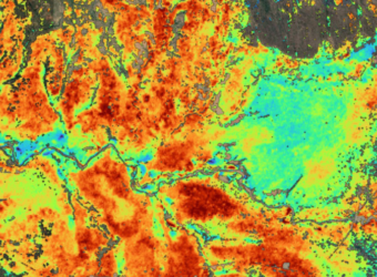
The GDA AID Climate Resilience consortium has completed the first prototype of an information product that estimates aboveground biomass in Mozambique forests to support the calculation and monitoring of greenhouse gas (GHG) emissions.
Agriculture, Forestry and Other Land use (AFOLU) is the second biggest source of GHG emissions globally (behind fossil fuels) and the largest source for many developing countries. Therefore, it is crucial to monitor forests and their emissions in countries like Mozambique.
New technologies and the unprecedented availability of satellite data are improving how emissions can be monitored in forestry. Thanks to newly available satellite data, cloud computing technology and artificial intelligence, carbon stocks can now be estimated across large areas. These new technologies enable the digitalisation of the Measurement, Reporting and Verification (MRV), a multi-step process to measure the amount of GHG emissions reduced by a specific mitigation activity.
Powered by earth observation data, the next generation of MRV systems, often called MRV 2.0, are a significant improvement than those that came before. Although some initiatives already pursue the implementation of digital MRV in the forest sector, few are exploring the use of satellite data to estimate carbon stock dynamics due to methodology issues. Demonstrating a successful prototype is crucial for the international community to consider such methods in the context of carbon markets or country reporting. In this context, the World Bank requested the GDA Climate Consortium to develop a prototype for the Measurement component of the MRV 2.0 system.
The prototype is a milestone for the World Bank’s Zambezia – Integrated Landscape Management Program (ZILMP) focused on the protection and the sustainable management of natural resources in Mozambique. It is one of two jurisdictional programmes established under the REDD+ framework which benefited from a US$ 8.6 million grant from the World Bank’s Forest Carbon Partnership Facility (FCPF). The REDD+ framework includes several activities aiming at reducing deforestation and degradation while ensuring the conservation and sustainable management of forests and the enhancement of carbon stocks.
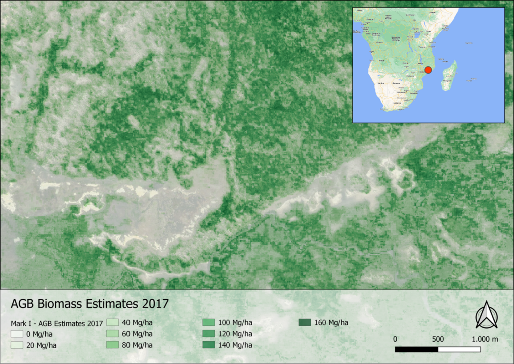
Implemented by GeoVille with the support of the CMCC Foundation, the prototype originated from a study led by GMV that assessed the readiness of various innovative technologies to identify how these can be combined and leveraged to foster a next-generation MRV. The findings from this study concluded that a next-generation MRV could perform better by using modern technology, such as incorporating higher confidence estimates from satellite-based methods.
The first prototype of the measurement component of the MRV 2.0 system was submitted In October 2022. The Word Bank and GDA Climate consortium jointly evaluated and discussed future product improvements. It was agreed that the first version reflects the limited accuracy that can be achieved without detailed ground-truth data and that the second version will be based on precise ground-truthing using LIDAR technology. The production of the second version is currently scheduled for early next year.
Upon successful demonstration, the objective of the World Bank is to scale up support and investments in remote-sensing-based digital MRV systems with the aim of increasing efficiency of MRV for land-use emissions reduction programs. Indeed, the integration of those new methods will enable client countries to report to World Bank land use climate funds more promptly and ultimately enable local communities to receive payments quicker. World Bank will integrate the biomass product into their next generation MRV prototype and use it as a baseline to monitor future changes in biomass, and through conversion, in carbon stocks, which in turn assess the performance of carbon reduction efforts in the target area.