GDA AID Urban Sustainability has been supporting the Asian Development Bank’s (ADB) “Integrated and Innovative Solutions for More Liveable Cities” project in Sargodha, Pakistan. This and an upcoming investment project have benefited from the expertise of the GDA AID Urban Sustainability consortium as Earth Observation (EO) can assist the green transformation of cities.
Offices and roads, but also, parks and forests
When we think of “urban infrastructure,” we often picture offices, railways, and roads. However, green urban infrastructure, such as parks and urban forests, is just as important, particularly for enhancing the liveability and resilience of cities and towns. Urban green transformation involves integrating green infrastructure and nature-based solutions into urban planning and development. The ADB “Integrated and Innovative Solutions for More Liveable Cities ” project is supporting several cities in Pakistan to accelerate this process. Sargodha, one of the cities benefiting from this, is home to 660,000 people, making it Pakistan’s 12th largest city and one of its fastest-growing urban areas.
A breath of fresh air
The GDA Urban Sustainability activity is currently supporting ADB, the Government of Punjab and the Municipal Corporation of Sargodha. A key aspect to green transformation is knowing the location, accessibility, and evolution of the city’s green spaces and how close these are to the citizens. This information allows investments in new green infrastructure such as new parks to be highly targeted to areas of greatest benefit, for example, for the citizens well-being or minimisation of flood risk.
GDA Urban Sustainability used satellite EO to provide an inventory of Sargodha’s green areas, and how these have been gained or lost over 2018-2021.

In the heat of the day
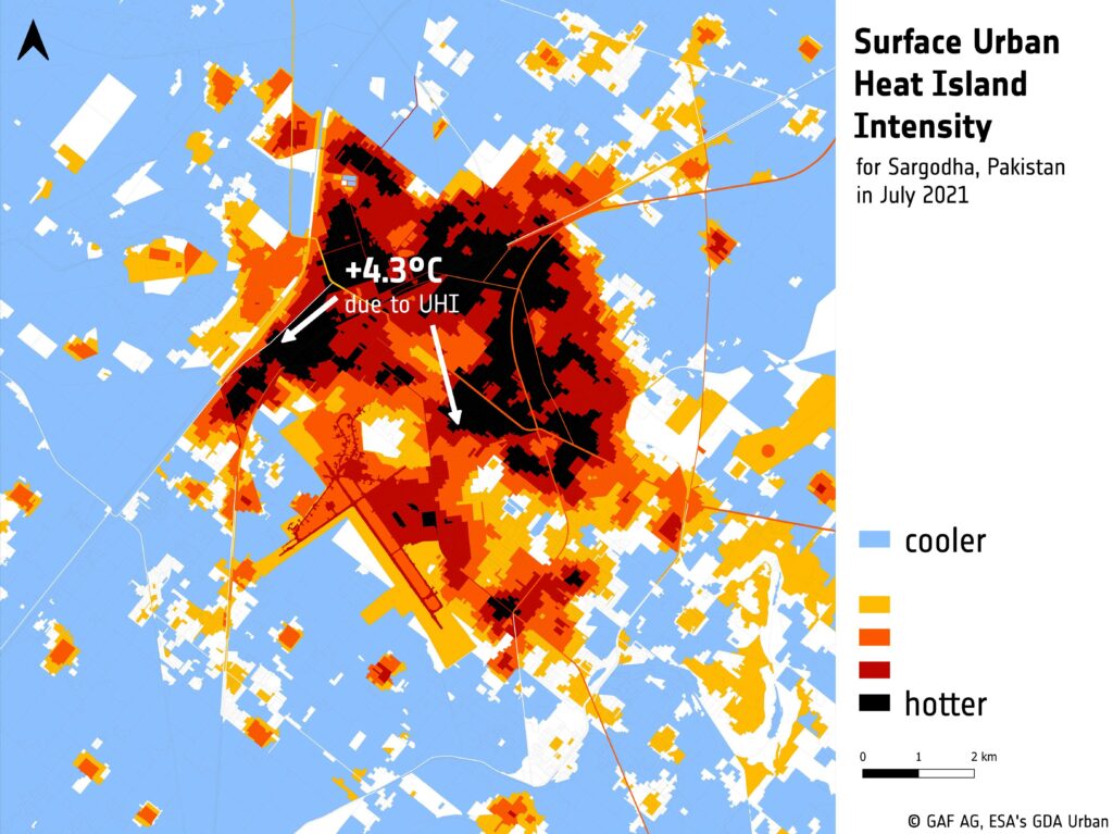
Urban Heat Islands are a critical factor that impacts both citizen well-being and energy consumption for cooling in cities. This phenomenon occurs when urban areas experience significantly higher surface temperatures, up to 3-5°C more than surrounding rural areas, due to human activities and the emission of heat by surfaces like buildings and roads. Understanding the location and intensity of Surface Urban Heat Islands (SUHI) is essential for making investment decisions related to green infrastructure. Such information helps to identify the areas where the implementation of sustainable urban development solutions, such as green roofs, cool pavements, and urban green spaces, could be most effective in mitigating the heat island effect and promoting a healthy and liveable environment for urban residents.
GDA Urban Sustainability conducted a cutting-edge analysis using satellite EO data to measure the relative intensity of the SUHI effect in Sargodha as indicated by land surface temperatures. The results of the analysis clearly illustrate significant temperature variations throughout the city, making this data an essential baseline for developing models that evaluate the impact of green spaces on different urban areas. In the case of Sargodha, a future ADB investment project called “Developing Resilient Environments and Municipal Services (DREAMS)” is set to make use of these insights.
Prioritising green investments for any city
The ADB and the Municipal Corporation of Sargodha have teamed up with GDA Urban Sustainability to leverage satellite-derived information and prioritise investments in green infrastructure. As a first step, these new insights were directly incorporated into the city’s Green Transformation Action Plan (GTAP) which proposes 16 Priority Actions to be implemented over a 10-year period. This strategic approach ensures that resources and funding are directed towards the areas of the city that will have the greatest positive impact on citizen well-being and resilience. At a national level, the GTAP also recommends the establishment of an Innovation Resource Hub as a central data warehouse providing decision-makers with the data-driven, satellite-supported geospatial information to adapt to and mitigate climate change in Pakistan.
Cities around the world, including those in Pakistan and Asia, face similar challenges when it comes to sustainable urban development. By using satellite EO data, city planners and policymakers can make informed decisions and take effective action towards creating sustainable urban environments. This valuable information helps them identify areas for improvement and implement solutions that promote cleaner, healthier, and more liveable cities for all residents.