Lake Victoria is Africa’s largest freshwater lake by area and delivers valuable ecosystem services to local communities including domestic use, industrial and agricultural water provision, waste disposal, and hydropower generation. It plays a prominent role for the landscape and can influence local meteorological and climate conditions. Lake Victoria is noted for a high diversity of fishes that are of economic, ecological, and scientific value. Nevertheless, the lake has already experienced deterioration due to unchecked or unregulated exploitation, invasive species, habitat degradation, pollution, and eutrophication. Predicted increases in climate variability and changes pose an additional threat that requires special attention.
Water Quality Assessment through Remote Sensing
Water quality assessment can be used as a tool for safeguarding human health, ecosystem resilience, and sustainable water resource utilisation. Assessing and maintaining clean water availability for drinking, agriculture, and industry are crucial for supporting life and economic activities around the lake.
In this context, the Lake Victoria Basin Commission, which is mandated to coordinate sustainable development and management of the Lake Victoria Basin in the 5 East African Community (EAC) Partner States, is working with the World Bank on the elaboration of the Lake-wide Inclusive Sanitation (LWIS) Investment Strategy in order to address those challenges. Under the European Space Agency’s (ESA) Global Development Assistance (GDA) Water Resources thematic area, Brockmann Consulting is supporting the definition of this strategy by delivering Earth Observation-based services on water quality monitoring, the assessment of dynamic changes and the analysis of the main factors driving pollution.
“Implementing water quality remote sensing is very helpful in addressing freshwater pollution at Lake Victoria. It marks the initial steps in identifying the drivers behind pollution and water quality changes, crucial for ecosystem functions like fisheries and human health.”
Jorrit Scholze, Water Remote Sensing Specialist at Brockmann Consult.
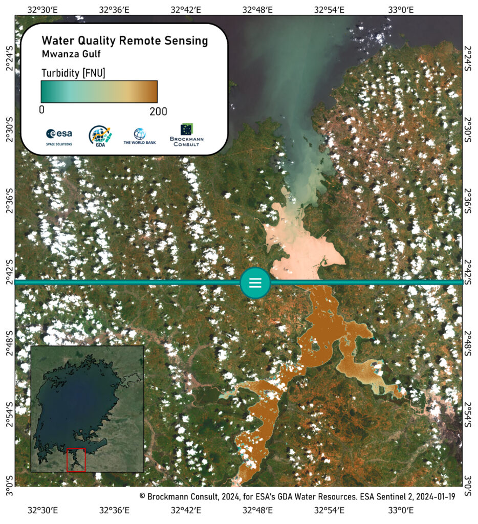
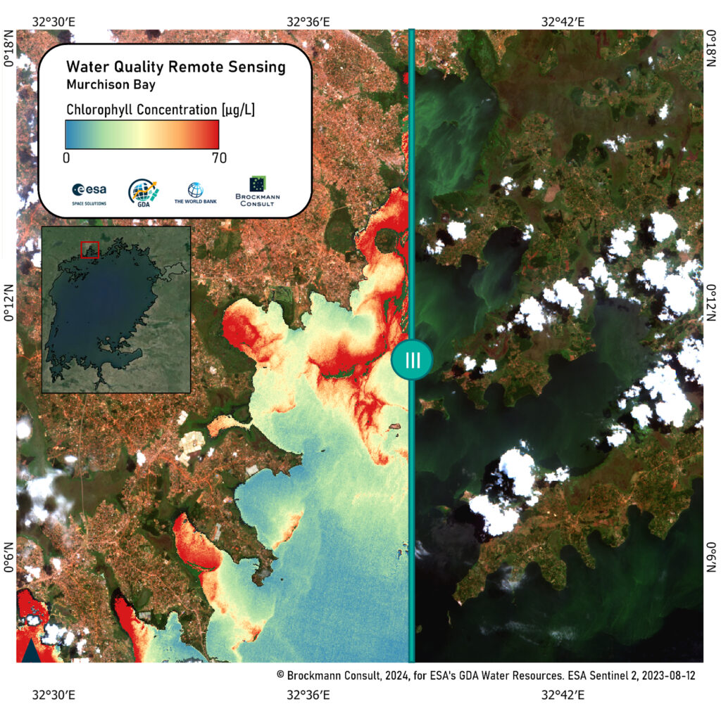
Remote sensing technology plays a crucial role in monitoring water quality and identifying its change drivers. Scaling up the use of remote sensing enables monitoring of water quality parameters like turbidity, chlorophyll-a, and harmful algae blooms and is used to better understand the drivers for water quality changes and to monitor the impact of water management infrastructure projects. These drivers, including climatic and anthropogenic factors such as precipitation and land cover/land use changes, interact in complex ways, influencing the lake’s ecosystem health and water quality and directly impact the livelihoods and well-being of the communities reliant on the lake’s resources. Remote sensing technologies consider all of these drivers to assess water quality changes, measure their impact on the lake’s ecosystem health, and identify hotspots of low water quality. This supports effective and localised water management strategies and ultimately enhances the lake’s water quality.
Long-term Impact for Effective Water Strategies and Local Water Management
The ESA’s GDA use case findings not only inform investment decisions on water management strategies but also support the goal of developing a regional water management program for the Lake Victoria Basin.
In 2024, the project will continue its assessment of water quality change drivers, ensuring an understanding of the dynamics affecting water quality in Lake Victoria. The analysis performed through ESA’s GDA Water Resources activity is currently being discussed with stakeholders, both in terms of its use and impact, as well as technical considerations for integrating the results into existing water management strategies at LVBC. In addition, some stakeholders have shown interest in additional analytical work on different topics such as water hyacinth monitoring. Ultimately, the goal is to enhance the resilience of the Lake Victoria Basin by implementing effective and localised water management strategies supported by the insights derived from the data and analysis of ESA’s GDA Water Resources use case with the ambition of replicating this approach across different geographies.
“Remote Sensing data and technologies have increasingly become an essential and an integral part of monitoring the health of transboundary water bodies like Lake Victoria amidst in-situ data collection challenges for such huge water bodies. Application of such data and technologies in the Lake Victoria basin will inform the identification of pollution control interventions.”
Benjamin Ssekamuli, Water Resources Modeler at the Lake Victoria Basin Commission
“ESA GDA’s technical support on monitoring Lake Victoria’s water quality through remote sensing complements the support that the World Bank’s Water Global Practice has been providing to the LVBC and LVB Partner States in addressing the lake’s pollution through Lakewide Inclusive Sanitation. Earth Observation and Remote Sensing tools are critical for both decision-making and monitoring of the impact of sanitation interventions.”
Pascaline Wanjiku Ndungu, Water and Sanitation Specialist at World Bank