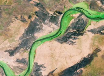
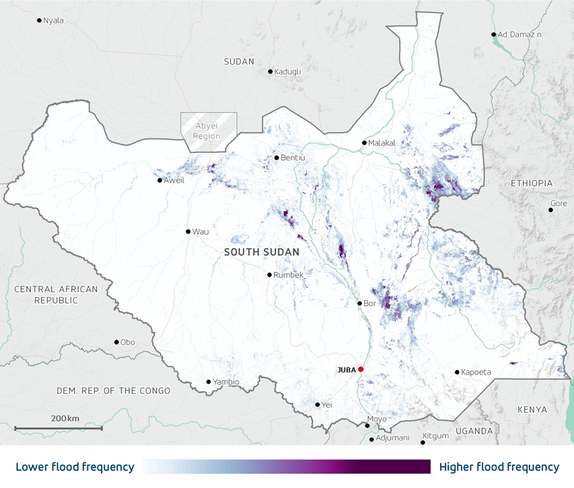
Earth observation (EO) data has been used to map flooding and precipitation trends in South Sudan, a country prone to flood risk and hydrological variability. In a strategic partnership with the World Bank, the European Space Agency (ESA) Global Development Assistance (GDA) Agile EO Information Development (AID) Climate Resilience Consortium leveraged Sentinel-1 high-resolution radar imagery to accurately track the extent, frequency, and duration of flooding in the country and create a comprehensive map of flood hazards.
The work contributes to Government of South Sudan’s objective of enhancing climate-resilient water resources management and bolstering resilience against floods in specific river basins. Through the Regional Climate Resilience Programme for Eastern and Southern Africa, the World Bank is supporting the Government in this vision to address flood risk in the country.
South Sudan is a global hotspot of flood risk, ranking 7th for the share of its population exposed to river floods. However, due to ongoing social and economic fragility, the population is unprepared to respond to flooding and deal with its consequences. This is in part due to a weak hydro-meteorological monitoring network and a lack of strategic flood hydrology models that can support long-term flood risk management.
Decision makers have insufficient information to develop effective flood management strategies and target their limited resources. Using EO data, the GDA Climate Resilience Consortium contributed to developing an understanding of the temporal and spatial patterns of flood hazard in the country. In turn, this can help the government take a proactive approach to mitigate the impacts of floods and foster climate resilience.
Long-term rainfall data from satellite and ground-based observations were analysed to identify regional precipitation anomalies and investigate links between precipitation and flooding. Using EO data to map flood hazards, precipitation trends, and anomalies at a regional scale is a novel approach and highly valuable for flood preparedness in the country.
Detailed flood hazard information can be used to raise awareness of flood risk among local institutions and communities. The results of the project have also contributed to better pinpoint the links between rainfall over Lake Victoria and flooding in South Sudan. This information has proved useful in ongoing discussion between the Government of South Sudan and the Lake Victoria Basin Commission, an intergovernmental organisation that promotes sustainable development and management of the natural resources within the Upper White Nile Basin.
Ministries have also used the data to develop an investment roadmap to enhance the country’s water information management system. For example, the EO analysis helped the Ministry of Water Resources and Irrigation to obtain a flood hazard map for the entire country and profile the flooding patterns in the sub-basins targeted under the World Bank-financed project. This information provides useful background for the entities that will be responsible for designing and constructing the infrastructure to be financed under the project.
Key Takeaways
- Earth observation data was used in South Sudan to map flooding and precipitation trends across the country, and transboundary basins.
- Sentinel-1 high-resolution radar imagery from ESA was used to monitor the extent of flooding and generate detailed flood hazard maps. Long-term rainfall data from satellite data and ground-based observations was analysed to map precipitation trends.
- The approach of using regional-scale EO data to map flood hazards and precipitation trends was new to the country.
- Improving ground-based observations in South Sudan through capacity building is essential for enhancing the accuracy and reliability of flood analysis based on Earth observation data.
ESA’s GDA Programme is a global partnership implemented with key International Financial Institutions (IFIs) – World Bank and Asian Development Bank – to mainstream the use of Earth Observation (EO) into development operations. For more information, please visit our website: https://gda.esa.int