










Natural hazards such as earthquakes and floods can pose significant, potentially compounding risks to population health, infrastructure, and the continuity of essential services across Jordan. However, information on the location, characteristics, and value of exposed assets remains incomplete and dispersed across institutions, limiting the Government’s ability to assess potential financing needs and identify priority assets and communities for resilience investments. The Earth observation (EO) tool helps address this gap by providing an initial, spatially consistent evidence base that can be progressively refined as additional national data become available. The tool was developed and tested as part of the World Bank-supported Jordan Disaster Risk Finance Diagnostic.
Building an integrated picture of earthquake and flood exposure
At the foundation of this work is the development of an integrated dataset capturing the spatial distribution of population, buildings, and healthcare infrastructure across Jordan. Drawing on globally available open data sources, including the Global Human Settlement Layer, WorldPop, the Microsoft Global Building Map, and healthsites.io, high-resolution population grids were disaggregated to the building level and classified by structural use, distinguishing residential and non-residential assets based on the Global Human Settlement Layer. Asset inventories covering health facilities were compiled alongside, providing an initial baseline for exposure analysis.
Building on this integrated infrastructure and population dataset, two dedicated exposure assessments were carried out. For seismic hazards, Peak Ground Acceleration data from the Global Earthquake Model’s Global Seismic Hazard Map were overlaid with the population and building inventory to estimate the number of individuals and structures potentially affected by earthquake activity. Exposure was assessed for both 2023 and 2030, providing a near-term temporal perspective on evolving risk.
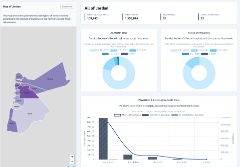
For flood hazards, flood extent data from the Fathom v3 dataset for 2030 were applied in an equivalent overlay analysis. By combining flood depth and extent information with the spatial distribution of buildings and population, the assessment yields estimates of the number of people and assets potentially exposed to flood events across the country.
Key Technical Feature: Exposure assessments for both earthquake and flood hazards combine globally available EO and geospatial datasets with building-level population and infrastructure inventories, enabling spatially explicit risk quantification at national scale.
Delivering actionable tools for risk finance
The results of the analysis were delivered not only as structured geospatial and tabular datasets, but also as interactive dashboards designed to make the findings accessible to non-EO experts. For practitioners requiring greater analytical flexibility, a Jupyter Notebook was provided to enable independent recalculation of exposure estimates as updated source data become available.
The exposure outputs are intended to serve as direct inputs, for example, to user-defined damage functions, linking physical asset exposure to potential economic losses and supporting the World Bank’s broader risk finance analytical activities in Jordan. They provide an indicative exposure baseline but should be interpreted noting that they estimate potential exposure to earthquake and flood hazards, not actual damage, economic losses, or fiscal liabilities.
A replicable framework for regional expansion
One of the strengths of the methodology developed in this case study is its transferability. Because the core input datasets covering population distribution, building footprints, seismic hazard, and flood extent are available at a global scale, the analytical framework can be replicated in other countries or regions with small adjustments. Hence, this methodical approach is equally extensible across hazard types, such as heatwaves, droughts, or landslides.
Expanding the scope to neighbouring countries, cross-border river basins, or additional urban centres would require modest adjustments to geographic boundaries and data inputs, while the underlying methodology and toolchain can remain largely unchanged. This scalability offers a practical pathway for building regional disaster risk intelligence in contexts where local data infrastructure may be limited.
Informing disaster risk finance and policy
The outputs of this case study are designed to bridge the gap between Earth observation science and financial risk management. By providing spatially explicit, asset-level exposure data, the products can benefit the World Bank and national partners with evidence-based approaches on disaster risk finance.
When integrated with damage functions and loss modelling, the EO-derived exposure datasets can support the design of financial protection instruments, guide infrastructure investment priorities, and strengthen the evidence base for climate adaptation planning in Jordan and the wider region.
Key takeaways
- Building-level exposure assessments for earthquake and flood hazards combine globally available EO data with population and infrastructure inventories for Jordan at the national scale.
- Interactive dashboards and a Jupyter Notebook deliver results in formats accessible to both non-technical users and analytical practitioners.
- The methodology can be adapted across geographies and, with additional hazard-specific methods, to other types of risk, providing a scalable framework for regional disaster risk assessment.